- Australia ▾
- Topographic
▾
- Australia AUSTopo 250k (2024)
- Australia 50k Geoscience maps
- Australia 100k Geoscience maps
- Australia 250k Geoscience maps
- Australia 1.1m Geoscience maps
- New Zealand 50k maps
- New Zealand 250k maps
- New South Wales 25k maps
- New South Wales 50k maps
- New South Wales 100k maps
- Queensland 10k maps
- Queensland 25k maps
- Queensland 50k maps
- Queensland 100k maps
- Compasses
- Software
- GPS Systems
- Orienteering
- International ▾
- Wall Maps
▾
- World
- Australia & New Zealand
- Countries, Continents & Regions
- Historical
- Vintage National Geographic
- Australian Capital Territory
- New South Wales
- Northern Territory
- Queensland
- South Australia
- Tasmania
- Victoria
- Western Australia
- Celestial
- Children's
- Mining & Resources
- Wine Maps
- Healthcare
- Postcode Maps
- Electoral Maps
- Nautical ▾
- Flags
▾
- Australian Flag Sets & Banners
- Flag Bunting
- Handwavers
- Australian National Flags
- Aboriginal Flags
- Torres Strait Islander Flags
- International Flags
- Flagpoles & Accessories
- Australian Capital Territory Flags
- New South Wales Flags
- Northern Territory Flags
- Queensland Flags
- South Australia Flags
- Tasmania Flags
- Victoria Flags
- Western Australia Flags
- Gifts ▾
- Globes ▾
Dear valued customer. Please note that our checkout is not supported by old browsers. Please use a recent browser to access all checkout capabilities


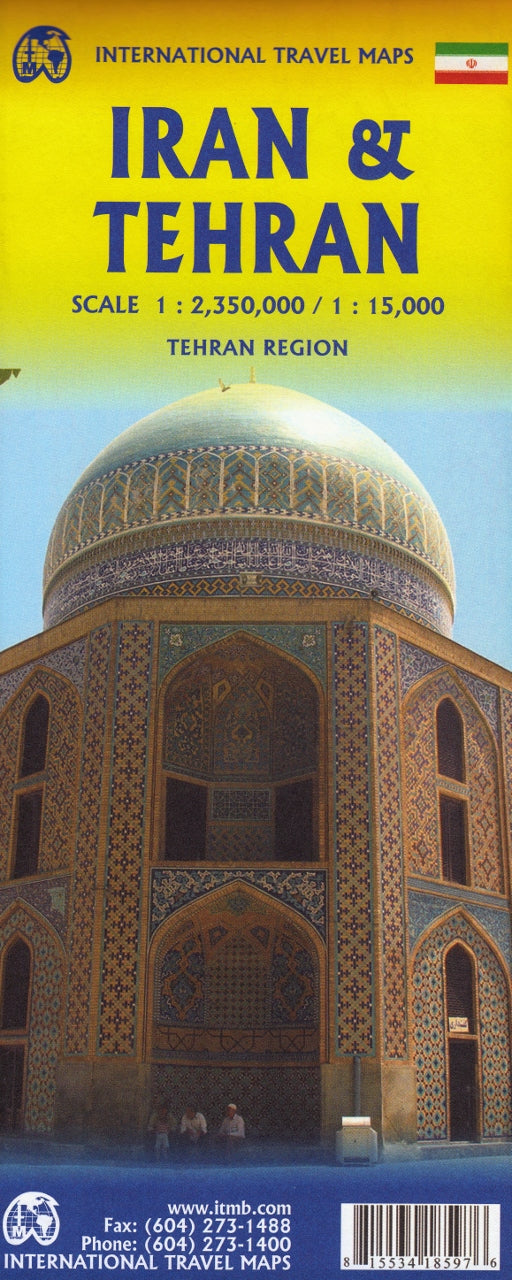
Iran & Tehran ITMB Map
$24.95
Afterpay is only available for orders between $50.00 and $1000.00 More info
Double-Sided | Tehran City Detail | Updated Edition
Scale: 1:1,800,000 (Country) / Larger Scale for Tehran
📐 Unfolded Size: 690 mm x 1000 mm
🇮🇷 Explore the Ancient Heart of Persia
From the sweeping deserts of Dasht-e Kavir to the snowcapped peaks of the Alborz Mountains, Iran is a land of dramatic contrasts and deep cultural resonance. With millennia of civilization etched into its soil, it is home to UNESCO World Heritage sites, legendary architecture, and some of the friendliest people on the planet. This beautifully designed double-sided map is your essential planning companion for discovering both Iran as a whole and the vibrant capital, Tehran.
Whether you're charting the ancient Silk Road, planning a tour of architectural marvels like Persepolis, or simply dreaming of the spice-scented bazaars of Shiraz, this map offers clarity, accuracy, and up-to-date cartography.
🌐 Key Features
| 🌟 Feature | 📌 Description |
|---|---|
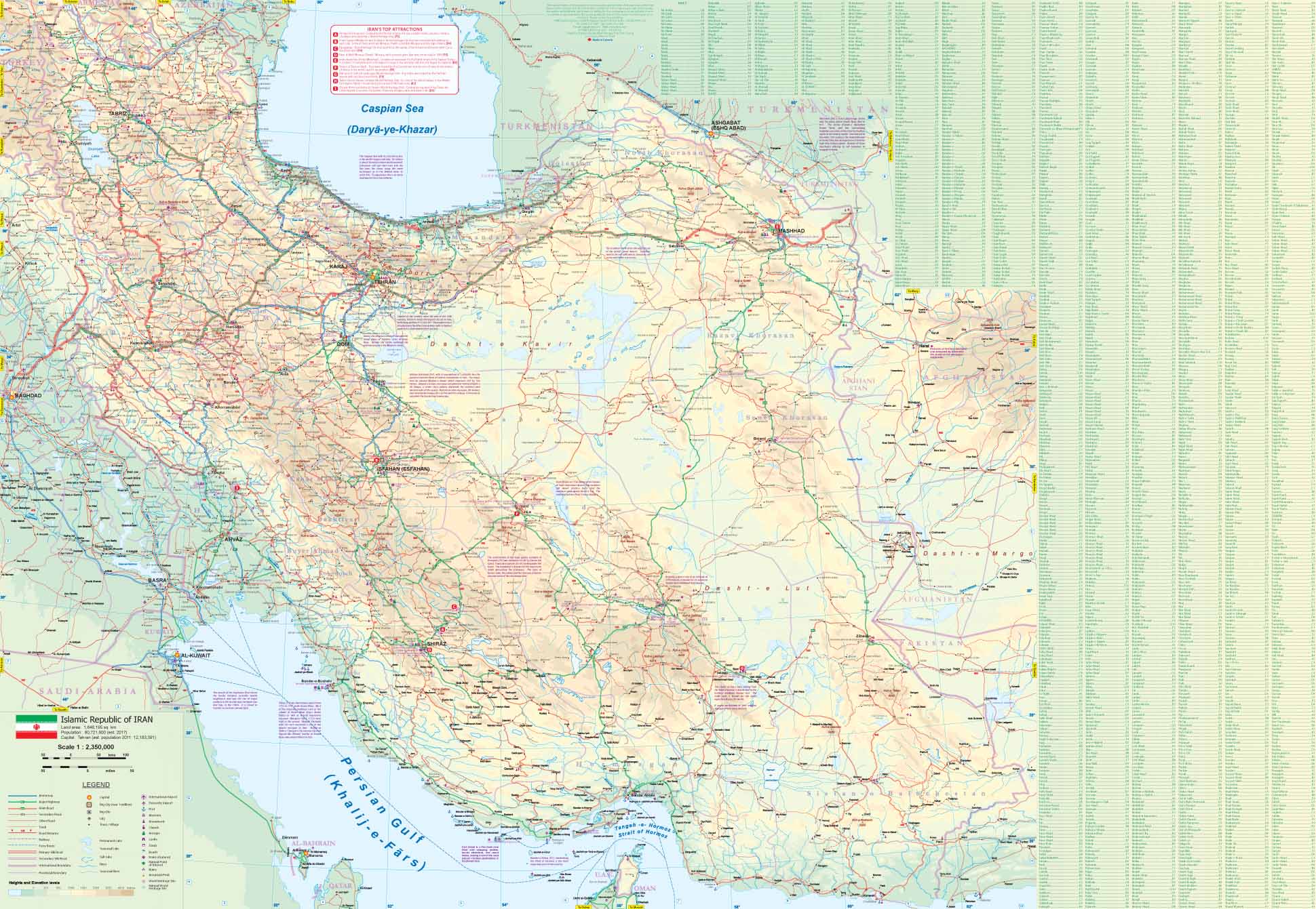
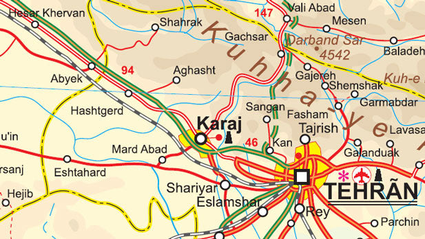
| Full Iran Country Map | Depicts the entirety of Iran including provincial borders, cities, towns, roads, rivers, and mountain ranges |
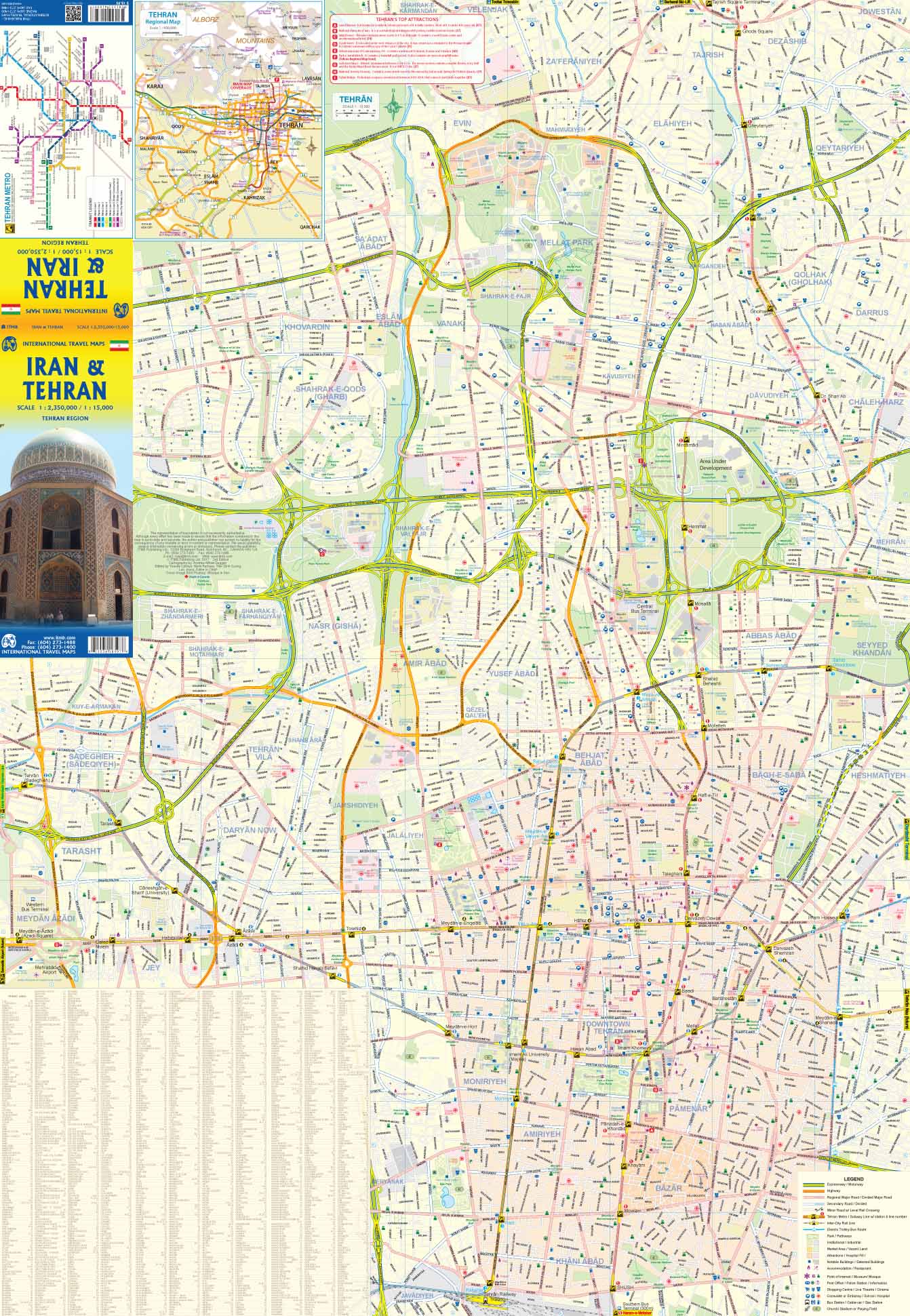
| Tehran City Inset | Includes a large-scale inset of the capital showing neighbourhoods, metro lines, major landmarks, and government buildings |
| Updated Motorway Network | Shows newly constructed and upgraded motorways and highways |
| International Borders | Clearly defined frontiers with Iraq, Turkey, Armenia, Azerbaijan, Turkmenistan, Afghanistan, and Pakistan |
| Topographic Relief | Gentle shaded relief shows elevation changes across Iran’s varied terrain |
| Cultural Highlights | Highlights mosques, caravanserais, archaeological ruins, natural wonders, and UNESCO World Heritage sites |
| Tourist Facilities | Includes airports, border crossings, and key transport hubs for logistics and overland travel |
| Strategic Road Connections | Shows all major road links to and from neighbouring countries, ideal for long-haul route planning |
| Dual Covers | Can be displayed on retail shelves or in a collection with either Iran or Tehran as the primary view |
📐 Map Specifications
| Specification | Detail |
|---|---|
| Map Type | Folded, double-sided |
| Publisher | International Travel Maps (ITMB) |
| Material | Paper (laminated option available) |
| Country Scale | 1:1,800,000 |
| City Inset Scale | Larger scale for central Tehran |
| Unfolded Size | 690 mm x 1000 mm |
| Folded Size | Compact for easy transport and storage |
🧭 Optional Lamination
Enhance your map with professional lamination, which:
-
✅ Makes the surface durable, waterproof, and tear-resistant
-
✅ Allows for use with whiteboard markers—perfect for trip planning or teaching
-
✅ Helps protect the map from wear, moisture, and accidental damage
🔧 Note: Laminated maps are created by flattening the folded sheet and encasing it in two sheets of 80-micron gloss laminate. Minor fold lines may still be visible.
👤 Who Is This Map For?
This versatile, high-quality map is ideal for:
-
🛫 Adventure travellers exploring lesser-known routes and historical regions
-
🧕 Cultural tourists visiting mosques, bazaars, and heritage sites
-
🎓 Students and educators seeking detailed cartographic resources
-
📚 Researchers and historians studying the region's geography and borders
-
📍 Overland explorers travelling across Iran or continuing into Central Asia
-
🗺️ Collectors and map lovers looking for a unique Middle Eastern map edition
🕌 Notable Destinations Highlighted
-
Tehran – capital city with bazaars, museums, and government districts
-
Isfahan – famed for its Islamic architecture and bridges
-
Shiraz – gateway to Persepolis, city of poets and gardens
-
Mashhad – site of the Blue Mosque and pilgrimage hub
-
Yazd – desert city with Zoroastrian fire temples and wind towers
-
Kerman, Tabriz, and Qom – key centres of commerce, religion, and history
-
Caspian Coast – forested northern shoreline with coastal resorts
-
Zagros Mountains – scenic western highlands ideal for trekkers
🛒 Why Choose This Map?
✔️ Up-to-date and accurate for reliable navigation
✔️ Double-sided format for comprehensive coverage
✔️ Premium paper or laminated upgrade
✔️ An indispensable tool for travel, study, or exploration
Embark on your journey across one of the world’s oldest civilizations with the Iran & Tehran Travel Map by ITMB.
From ancient Silk Road cities to modern highways and hidden desert paths, this map is your key to exploring Iran with confidence.


