- Australia ▾
- Topographic
▾
- Australia AUSTopo 250k (2025)
- Australia 50k Geoscience maps
- Australia 100k Geoscience maps
- Australia 250k Geoscience maps
- Australia 1:1m Geoscience maps
- New Zealand 50k maps
- New Zealand 250k maps
- New South Wales 25k maps
- New South Wales 50k maps
- New South Wales 100k maps
- Queensland 10k maps
- Queensland 25k maps
- Queensland 50k maps
- Queensland 100k maps
- Western Australia 25k maps
- Western Australia 50k maps
- Western Australia 100k maps
- Compasses
- Software
- GPS Systems
- International ▾
- Wall Maps
▾
- World
- Australia & New Zealand
- Countries, Continents & Regions
- Historical
- Vintage National Geographic
- Australian Capital Territory
- New South Wales
- Northern Territory
- Queensland
- South Australia
- Tasmania
- Victoria
- Western Australia
- Celestial
- Children's
- Mining & Resources
- Wine Maps
- Healthcare
- Postcode Maps
- Electoral Maps
- Nautical ▾
- Flags
▾
- Australian Flag Sets & Banners
- Flag Bunting
- Handwavers
- Australian National Flags
- Aboriginal Flags
- Torres Strait Islander Flags
- International Flags
- Flagpoles & Accessories
- Australian Capital Territory Flags
- New South Wales Flags
- Northern Territory Flags
- Queensland Flags
- South Australia Flags
- Tasmania Flags
- Victoria Flags
- Western Australia Flags
- Gifts ▾
- Globes ▾
Dear valued customer. Please note that our checkout is not supported by old browsers. Please use a recent browser to access all checkout capabilities


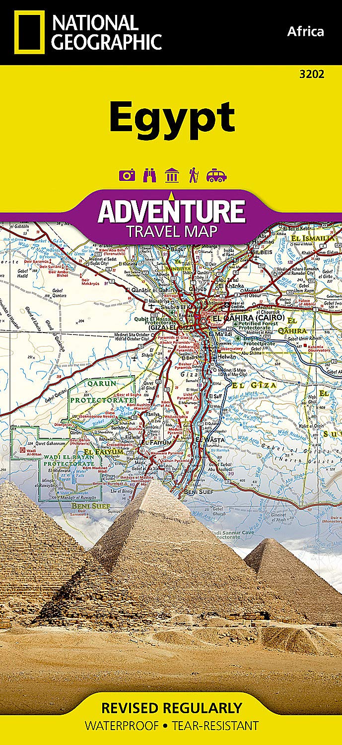
Egypt National Geographic Folded Map
$27.95
Afterpay is only available for orders between $50.00 and $1000.00 More info
🇪🇬 Egypt Adventure Map – National Geographic
Double-Sided | Waterproof & Tear-Resistant | Designed for Travel
Scale: 1:800,000 (approximate)
Flat Size: 965 mm x 660 mm (38" x 26")
Folded Size: 235 mm x 108 mm (9.25" x 4.25")
Material: Durable Synthetic Paper
Experience the timeless land of pharaohs, pyramids, and the Nile with the National Geographic Egypt Adventure Map. Designed specifically for adventurous travellers, this durable and detailed two-sided map offers an expert blend of geographic clarity and cultural insight, taking you from bustling urban centres to remote desert oases with confidence.
Perfect for planning, navigating, or exploring Egypt by road, river, or rail, this map highlights hundreds of points of interest and clearly marks cities, archaeological sites, protected areas, and natural landmarks.
🗺️ Map Coverage
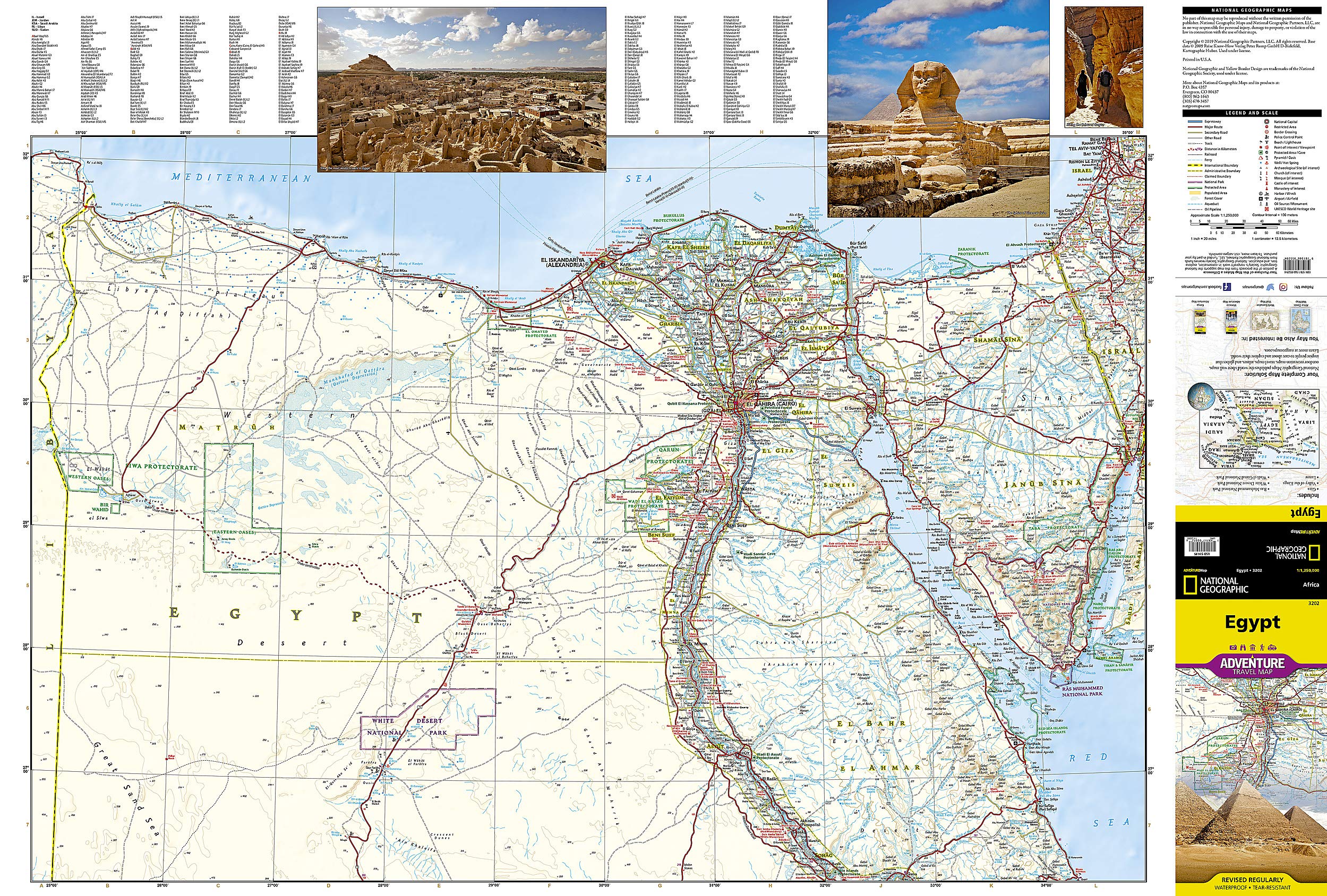
🧭 Side 1: Northern Egypt
-
Covers the region from the Mediterranean Sea south through:
-
Alexandria
-
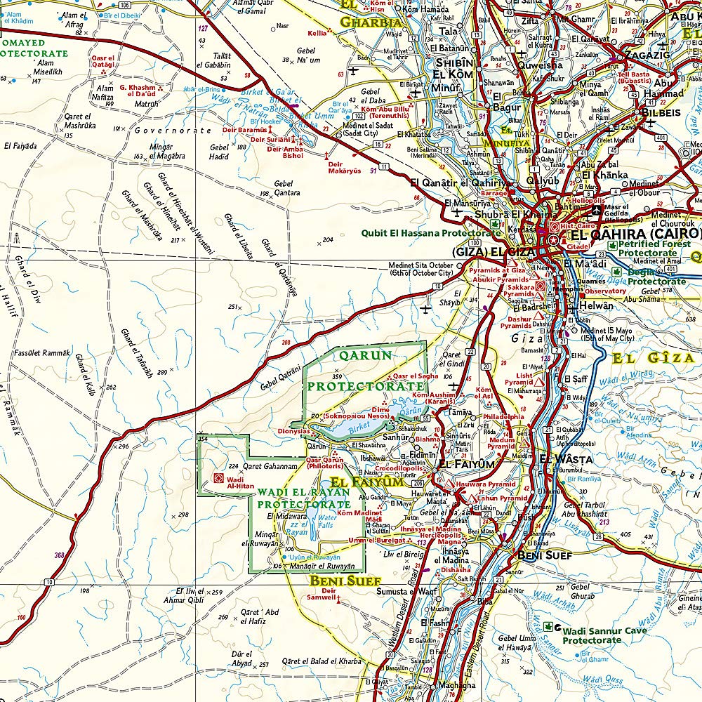
Cairo & Giza
-
Faiyum
-
Beni Suef
-
Minya
-
Asyut
-
Sohag
-
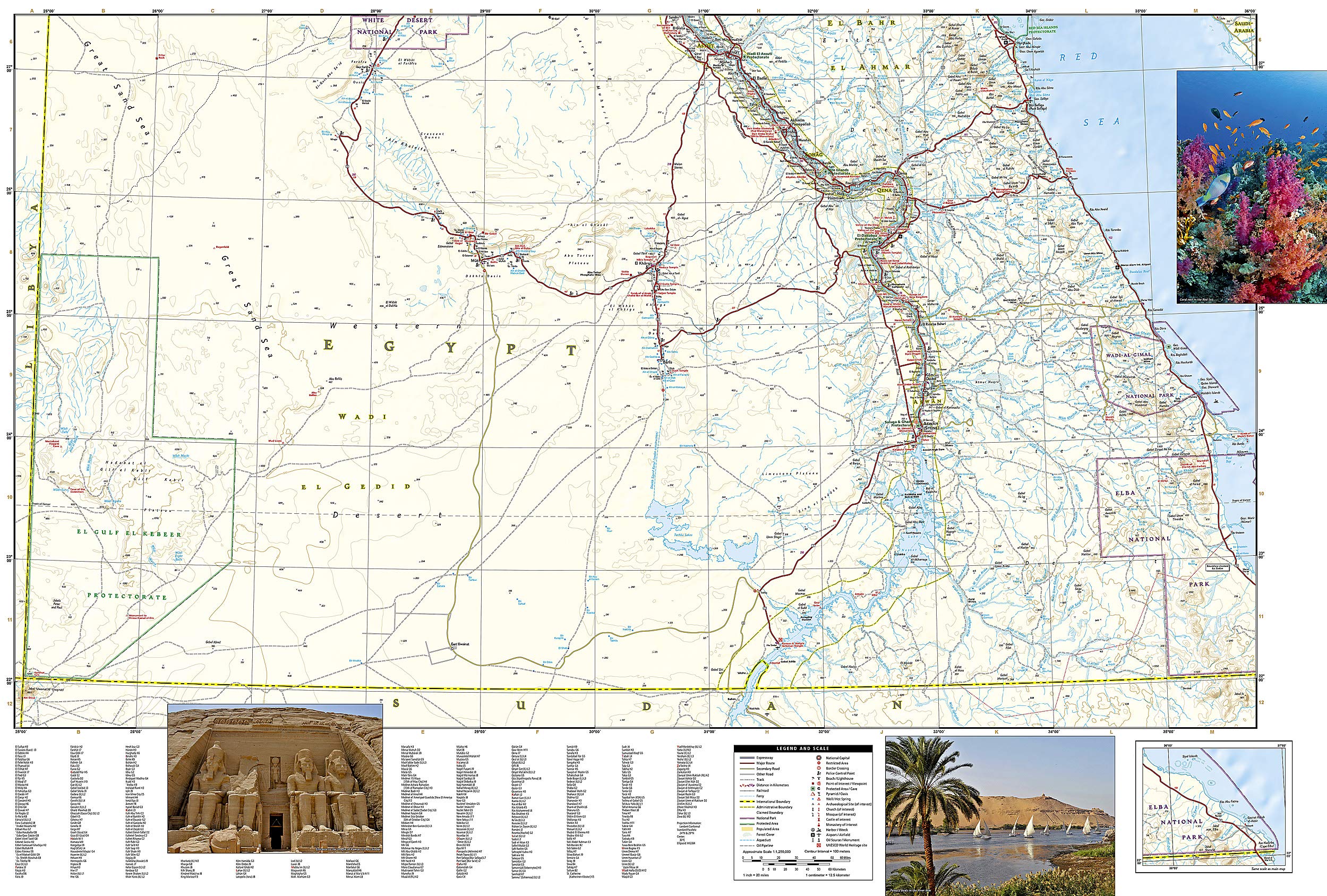
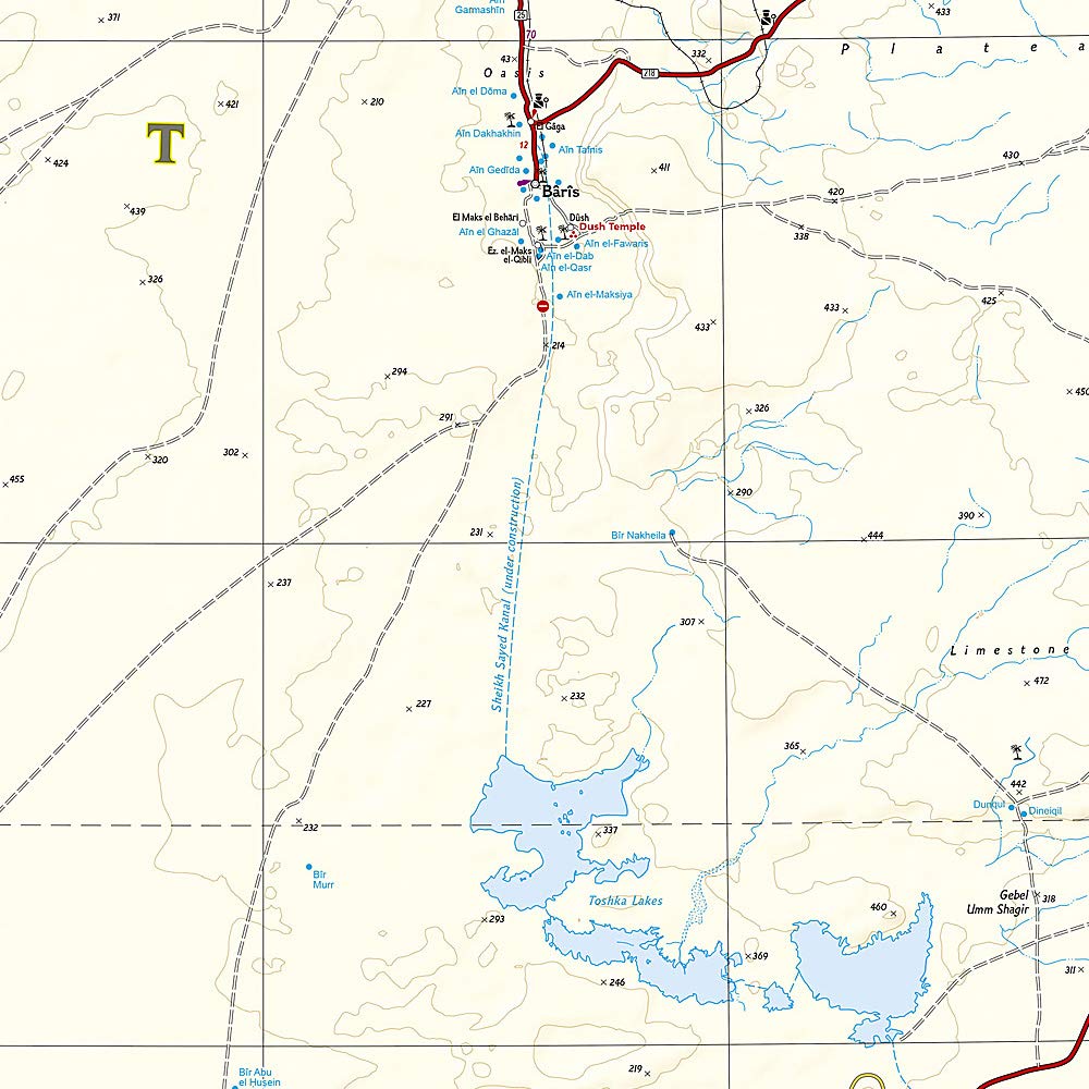
🏜️ Side 2: Southern Egypt
-
Focuses on Upper Egypt, featuring:
-
Luxor & Karnak
-
Aswan & Abu Simbel
-
Nag Hammadi, Qena, and Esna
-
The Western Desert oases of Kharga and Dakhla
-
🌟 Key Features
-
🗺️ Two-sided map offers complete national coverage
-
🏛️ Tourist highlights including ancient temples, pyramids, ruins, and museums
-
🚗 Clearly marked road network:
-
Highways, main roads, and secondary routes
-
Tracks and trails for off-the-beaten-path travel
-
Distances between major cities indicated
-
-
🌍 Protected areas and national parks marked
-
🧾 User-friendly place name index for easy navigation
-
🧭 Latitude and longitude grid for GPS reference
💧 Built for Adventure
Printed on waterproof, tear-resistant synthetic paper, this map is built to withstand the challenges of desert wind, boat decks, long road trips, and rugged backpacks. Whether you're navigating ancient ruins or cruising the Nile, it's made to last.
🧾 Map Specifications
| Feature | Details |
|---|---|
| Publisher | National Geographic |
| Map Type | Folded, double-sided |
| Material | Waterproof synthetic paper |
| Flat Size | 965 mm x 660 mm (38" x 26") |
| Folded Size | 235 mm x 108 mm (9.25" x 4.25") |
| Language | English |
| Edition | Most recent available |
🧳 Who Is This Map For?
Perfect for:
-
✈️ Adventure travellers planning to explore Egypt’s natural and cultural sites
-
🏛️ History buffs and archaeology fans visiting the Valley of the Kings, Luxor, or Karnak
-
🧭 Self-guided tourists travelling by car, bus, or boat
-
🗺️ Students and educators needing a rugged, reference-grade map
-
🧳 Tour guides and operators providing clients with a reliable planning tool
📍 Why Choose a National Geographic Adventure Map?
National Geographic Adventure Maps are trusted by explorers worldwide for their accuracy, rugged design, and user-friendly layout. This Egypt edition is no exception—balancing cultural landmarks with topographical detail and practical travel information, all in one highly portable format.
Frequently Asked Questions
What area does the Egypt National Geographic Folded Map cover?
The Egypt National Geographic Folded Map provides road coverage of the region named in the product title. The map covers major cities, highways, towns, and regional roads, with inset city maps for key urban centres where applicable.
Is the Egypt National Geographic Folded Map up to date?
Yes, this is the current edition. Mapworld stocks the most current editions from all major publishers, updated to reflect new roads and infrastructure.
What size is this map when unfolded?
Folded maps from Mapworld's range are compact and portable. Most standard folded road or travel maps open to between A1 (594 × 841mm) and A0 (841 × 1189mm) when fully unfolded, and fold down to approximately A4 or smaller for easy storage in a glove box, bag, or backpack.
Is the Egypt National Geographic Folded Map in stock at Mapworld?
Mapworld maintains extensive stock across its map range and aims for fast dispatch. Orders placed before 2pm AEST on business days are typically dispatched the same day, with standard and express Australia-wide delivery options available.
Does Mapworld ship the Egypt National Geographic Folded Map across Australia?
Yes, Mapworld ships Australia-wide. Standard shipping is a flat $7 rate, with free standard shipping on orders over $75. Express options are available at checkout. Most orders placed before 2pm AEST on weekdays are dispatched same day.
Related Items


© 2026 Mapworld. Website designed by Genie Media
X