- Australia ▾
- Topographic
▾
- Australia AUSTopo 250k (2025)
- Australia 50k Geoscience maps
- Australia 100k Geoscience maps
- Australia 250k Geoscience maps
- Australia 1:1m Geoscience maps
- New Zealand 50k maps
- New Zealand 250k maps
- New South Wales 25k maps
- New South Wales 50k maps
- New South Wales 100k maps
- Queensland 10k maps
- Queensland 25k maps
- Queensland 50k maps
- Queensland 100k maps
- Compasses
- Software
- GPS Systems
- Orienteering
- International ▾
- Wall Maps
▾
- World
- Australia & New Zealand
- Countries, Continents & Regions
- Historical
- Vintage National Geographic
- Australian Capital Territory
- New South Wales
- Northern Territory
- Queensland
- South Australia
- Tasmania
- Victoria
- Western Australia
- Celestial
- Children's
- Mining & Resources
- Wine Maps
- Healthcare
- Postcode Maps
- Electoral Maps
- Nautical ▾
- Flags
▾
- Australian Flag Sets & Banners
- Flag Bunting
- Handwavers
- Australian National Flags
- Aboriginal Flags
- Torres Strait Islander Flags
- International Flags
- Flagpoles & Accessories
- Australian Capital Territory Flags
- New South Wales Flags
- Northern Territory Flags
- Queensland Flags
- South Australia Flags
- Tasmania Flags
- Victoria Flags
- Western Australia Flags
- Gifts ▾
- Globes ▾
Dear valued customer. Please note that our checkout is not supported by old browsers. Please use a recent browser to access all checkout capabilities
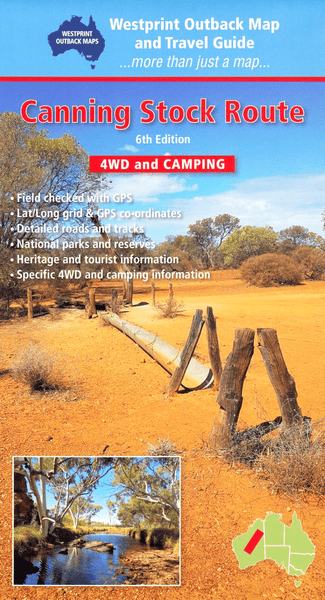
Canning Stock Route Map Westprint
$18.95 $19.95
Afterpay is only available for orders between $50.00 and $1000.00 More info
🐪 Canning Stock Route Map – Westprint
1:1,000,000 Scale | Comprehensive 4WD Touring & Heritage Map | GPS-Compatible
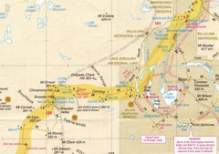
Trace the footsteps of Australia’s toughest overland drovers with the Canning Stock Route Map by Westprint — the most detailed and informative map available for navigating one of the world’s longest and most remote 4WD tracks.
Stretching over 1,800 kilometres through Western Australia’s rugged deserts, the Canning Stock Route is legendary among adventurers. This map offers not only accurate road and track information but also a wealth of historical context, Indigenous cultural references, and practical travel advice tailored for off-road travellers, campers, and overlanders.
🧭 Key Features:
-
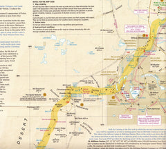
✅ Unrivalled Track Detail – The most complete mapping available for the entire Canning Stock Route
-
📍 Lat/Long Grid + GPS Waypoints – Navigate confidently with accurate coordinates
-
🛣️ Detailed Roads & Tracks – Includes minor desert tracks, access roads, and side trips
-
🏕️ 4WD, Caravan & Camping Information – Clearly marked rest stops, water points, campsites, and fuel locations
-
🏞️ National Parks & Conservation Reserves – Includes adjacent natural areas and protected zones
-
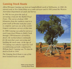
🐪 Historical & Heritage Notes – Learn about Alfred Canning, the 51 original wells, and the cultural significance of this iconic route
-
🛑 Safety & Permit Information – Practical notes for travel in remote desert terrain, including contact numbers and access requirements
🗺️ Coverage Highlights:
-
The full Canning Stock Route from Wiluna in the south to Halls Creek in the north
-
Key sites: Wells 1–51, Durba Springs, Georgia Bore, and Kunawarritji
-
Access routes to fuel, food, and medical help
-
Surrounding desert regions including the Gibson Desert, Little Sandy Desert, and Great Sandy Desert
📐 Map Specifications:
| Feature | Detail |
|---|---|
| Scale | 1:1,000,000 |
| Publisher | Westprint Heritage Maps |
| Dimensions | Folded touring map (full-size) |
| Map Type | Paper, folded (laminated version may be available) |
| GPS Compatible | Yes – includes Lat/Long grid |
🚐 Perfect For:
-
4WD expeditions along the Canning Stock Route
-
Long-distance overlanding and desert exploration
-
Adventure travellers seeking solitude and history
-
Travellers needing clear GPS-based navigation support
-
Educational use or historical research into Australia’s inland development
One of Australia’s greatest outback adventures deserves the best navigation tool. Whether you're tackling the route solo or with a convoy, Westprint's Canning Stock Route Map will keep you on track, informed, and inspired across the red heart of the continent.
📦 Order now and get ready to follow the wheel ruts of legends.


