- Australia ▾
- Topographic
▾
- Australia AUSTopo 250k (2024)
- Australia 50k Geoscience maps
- Australia 100k Geoscience maps
- Australia 250k Geoscience maps
- Australia 1.1m Geoscience maps
- New Zealand 50k maps
- New Zealand 250k maps
- New South Wales 25k maps
- New South Wales 50k maps
- New South Wales 100k maps
- Queensland 10k maps
- Queensland 25k maps
- Queensland 50k maps
- Queensland 100k maps
- Compasses
- Software
- GPS Systems
- Orienteering
- International ▾
- Wall Maps
▾
- World
- Australia & New Zealand
- Countries, Continents & Regions
- Historical
- Vintage National Geographic
- Australian Capital Territory
- New South Wales
- Northern Territory
- Queensland
- South Australia
- Tasmania
- Victoria
- Western Australia
- Celestial
- Children's
- Mining & Resources
- Wine Maps
- Healthcare
- Postcode Maps
- Electoral Maps
- Nautical ▾
- Flags
▾
- Australian Flag Sets & Banners
- Flag Bunting
- Handwavers
- Australian National Flags
- Aboriginal Flags
- Torres Strait Islander Flags
- International Flags
- Flagpoles & Accessories
- Australian Capital Territory Flags
- New South Wales Flags
- Northern Territory Flags
- Queensland Flags
- South Australia Flags
- Tasmania Flags
- Victoria Flags
- Western Australia Flags
- Gifts ▾
- Globes ▾
Dear valued customer. Please note that our checkout is not supported by old browsers. Please use a recent browser to access all checkout capabilities
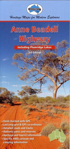
Anne Beadell Highway Map Westprint
$9.95
Afterpay is only available for orders between $50.00 and $1000.00 More info
A Trusted Guide to One of Australia’s Most Remote 4WD Journeys
The Anne Beadell Highway Map by Westprint is your essential travel companion for tackling one of the most remote and iconic outback tracks in Australia. Spanning from Coober Pedy in South Australia to Laverton in Western Australia, this rugged 4WD route crosses vast deserts, remote Aboriginal lands, and remarkable landscapes steeped in history, challenge, and natural wonder.
Crafted with meticulous attention to detail, this map goes far beyond navigation — it offers field-verified accuracy, extensive historical insights, and practical guidance for every leg of your journey along this legendary route named after Len Beadell’s wife, Anne.
🔍 Key Map Features:
-
✅ Detailed Road and Track Information
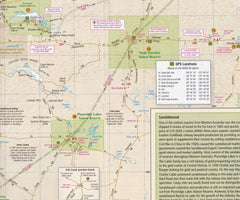
Covers the full extent of the Anne Beadell Highway, including Ilkurlka, Emu Junction, Volkes Hill Corner, and access tracks to key landmarks such as Maralinga, Tallaringa Conservation Park, and the Great Victoria Desert. -
🌄 Topographic Features
Terrain shading, natural features, desert regions, dunes, and salt lakes are clearly marked to assist with trip planning and awareness of conditions. -
🗺️ Points of Interest with Reference Coding
A unique number-coded system links locations on the map with detailed text descriptions on the reverse, allowing for a deeper understanding of historical sites, camps, and landscapes. -
📜 Historical and Exploration Context
Includes stories and details from Len Beadell’s legendary road-building expeditions, along with insights into early European explorers and Indigenous heritage. -
🚙 4WD, Camping, and Travel Information
Covers critical details for remote area travel including:-
Vehicle preparation tips
-
Camping site suggestions
-
Fuel and supply points
-
Road conditions and navigation advice
-
-
🧭 GPS-Checked Accuracy
Field-verified with GPS coordinates to ensure accuracy in remote terrain. -
🧾 Permits & Contacts
Includes up-to-date permit information for entering Aboriginal lands and restricted areas, along with emergency contact numbers and travel advisory notes.
🏕️ Who This Map Is For:
-
4WD travellers seeking the challenge and solitude of the Australian interior
-
Adventurers and explorers tracing the legacy of Len Beadell’s Gunbarrel Road Construction Party
-
History buffs and outback enthusiasts interested in atomic test history and exploration routes
-
Overlanders and caravanners needing reliable and detailed travel guidance in remote zones
-
Ecologists and nature lovers wanting insights into the flora and fauna of the Great Victoria Desert
📘 Product Specifications:
| Specification | Detail |
|---|---|
| Title | Anne Beadell Highway Map |
| Publisher | Westprint Heritage Maps |
| Scale | 1:1,750,000 |
| Map Type | Folded touring map |
| Coverage | Coober Pedy (SA) to Laverton (WA), including Maralinga and Emu Junction |
| Reverse Content | Historical notes, 4WD advice, permit and contact info |
| GPS Reference | Included throughout |
| Printed in | Australia |
🚐 Travel with Confidence Across Australia's Red Heart
Crossing some of the most beautiful, barren, and unforgiving terrain in the world, the Anne Beadell Highway demands preparation, resilience, and a reliable map. With Westprint’s expertly researched edition, you’re well-equipped to make your journey not only safe — but unforgettable.


