Size: 1100 mm x 780 mm | Scale: 1:36,384,000 | Published 2021
Available in Paper, Laminated, or Canvas Finish | Made in Australia
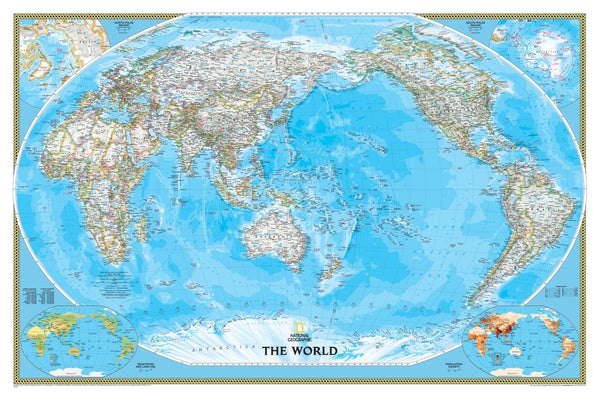
Reimagine the world as seen from the Pacific with this beautifully rendered World Political Map by the National Geographic Society. Centred on the vast Pacific Ocean rather than the conventional Africa-based view, this map offers a refreshing and informative new perspective of global geography.
Rendered in National Geographic's classic palette of blue oceans and crisp white landmasses, the map combines elegant design with exceptional cartographic accuracy, making it an ideal feature for your home, office, classroom, or study.
🧭 Map Highlights
-
Pacific-Centred Projection
Offers an alternative global perspective, placing Australia, New Zealand, Asia, and the Americas in clearer spatial context. -
Winkel Tripel Projection
Designed to minimise distortion of landmass shapes and sizes, especially near the poles—making this one of the most balanced and visually accurate world maps available. -
High-Definition Political Detail
Features clearly defined national borders using bold coloured lines, with interior areas in white for optimal legibility. Country names, capital cities, major towns, and geographic features are labelled with precision. -
Physical Relief & Oceanographic Detail
Mountain ranges are subtly rendered using shaded relief, while ocean bathymetry and major currents are shown in nuanced colour gradients—ideal for educators and map enthusiasts alike. -
Informative Insets
Includes supplementary maps in the bottom corners depicting:-
🌍 Population Density
-
🌿 Vegetation
-
🌾 Land Use
-
🖼️ Finishing Options
Choose the format that best suits your space and purpose:
-
Heavyweight Paper (160 gsm)
Perfect for framing under glass; a refined option for offices or studies. -
Laminated
Durable and wipe-clean, our lamination uses two sheets of 80-micron gloss laminate to protect the map from spills, stains, and tears. Suitable for classrooms and busy workspaces. -
Canvas (395 gsm HP Professional Matte)
Printed with fade-resistant pigment inks for gallery-quality colour and archival durability. A visually stunning and tactile finish, ideal for interior design or frequent handling.
🪵 Optional Hanging System
For an elegant display, select the hang rail option with natural timber battens attached to the top and bottom edges. A sturdy cord is fixed to the top rail for effortless hanging from a single hook or nail.
🛠️ Please note: maps with hang rails require 10 working days for delivery as they are custom-assembled by our professional framer.
📐 Product Specifications
| Feature | Details |
|---|---|
| Title | World Political – Pacific-Centred |
| Publisher | National Geographic Society |
| Projection | Winkel Tripel |
| Map Scale | 1:36,384,000 |
| Dimensions | 1100 mm (w) x 780 mm (h) |
| Finish Options | Paper, Laminated, or Canvas |
| Printed In | Australia |
| Published | 2021 |
🌐 Perfect For:
-
🏡 Home décor – A conversation-starting centrepiece
-
📚 Educational settings – Accurate, content-rich, and classroom-ready
-
🗺️ Geography enthusiasts – A unique addition to your map collection
-
🏢 Business or boardrooms – Clear and elegant world overview
-
🎁 Gift idea – For travellers, educators, or global thinkers
🛒 Add to Cart Today
See the world from a new angle—literally. The Pacific-Centred World Political Map by National Geographic combines timeless design with geographic insight, creating a stunning and practical reference that brings global context to any wall.
Order now and enjoy the clarity, quality, and craftsmanship of a map made for explorers of every kind.


