- Australia ▾
- Topographic
▾
- Australia AUSTopo 250k (2024)
- Australia 50k Geoscience maps
- Australia 100k Geoscience maps
- Australia 250k Geoscience maps
- Australia 1.1m Geoscience maps
- New Zealand 50k maps
- New Zealand 250k maps
- New South Wales 25k maps
- New South Wales 50k maps
- New South Wales 100k maps
- Queensland 10k maps
- Queensland 25k maps
- Queensland 50k maps
- Queensland 100k maps
- Compasses
- Software
- GPS Systems
- Orienteering
- International ▾
- Wall Maps
▾
- World
- Australia & New Zealand
- Countries, Continents & Regions
- Historical
- Vintage National Geographic
- Australian Capital Territory
- New South Wales
- Northern Territory
- Queensland
- South Australia
- Tasmania
- Victoria
- Western Australia
- Celestial
- Children's
- Mining & Resources
- Wine Maps
- Healthcare
- Postcode Maps
- Electoral Maps
- Nautical ▾
- Flags
▾
- Australian Flag Sets & Banners
- Flag Bunting
- Handwavers
- Australian National Flags
- Aboriginal Flags
- Torres Strait Islander Flags
- International Flags
- Flagpoles & Accessories
- Australian Capital Territory Flags
- New South Wales Flags
- Northern Territory Flags
- Queensland Flags
- South Australia Flags
- Tasmania Flags
- Victoria Flags
- Western Australia Flags
- Gifts ▾
- Globes ▾
Dear valued customer. Please note that our checkout is not supported by old browsers. Please use a recent browser to access all checkout capabilities
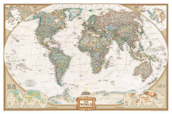
World Executive Antique Style National Geographic 1852 x 1219mm (Africa Centred) Super Laminated Wall Map with Hang Rails
$499.95
or make 4 interest-free payments of
$124.99 AUD
fortnightly with
![]() More info
More info
Antique Style | Laminated with Wooden Hang Rails | Africa-Centred | 1852 × 1219 mm
🌍 Classic Elegance Meets Global Insight
Elevate your space with National Geographic’s World Executive Political Map—a masterful blend of antique cartographic style and the most up-to-date political geography. With its elegant earth-tone palette, Africa-centred projection, and grand scale of 1852 × 1219 mm, this laminated wall map is both a powerful reference and a timeless piece of décor.
Designed for discerning professionals, educators, and lifelong learners, this map makes a commanding statement in boardrooms, classrooms, libraries, and homes alike.
🧭 Key Features
| 🌟 Feature | 📝 Description |
|---|---|
| Africa-Centred Orientation | Offers a more balanced global view, avoiding Eurocentric bias—ideal for understanding southern hemisphere dynamics |
| Winkel Tripel Projection | National Geographic’s preferred projection for minimising distortion while preserving shape, scale, and distance |
| Up-to-Date Political Boundaries | Reflects current geopolitical divisions with capitals, major cities, and international borders |
| Antique Styling | Earth-toned colours in rich browns, greens, and sepia shades evoke the golden age of exploration while blending into both traditional and modern interiors |
| Topographic Shading | Subtle relief shows mountain ranges, plateaus, and sea depths for geographic context |
🔍 Thematic Insets
Three inset maps in the lower corners offer even deeper insight:
-
🌍 Global Population Density
-
🌿 Vegetation Patterns
-
🌾 Land Use & Agriculture
These extras make this map a valuable resource for education, research, and strategic planning.
💎 Premium Laminated Finish
-
Printed on 120 gsm heavyweight matte-coated paper
-
Fully encapsulated between two sheets of 80-micron gloss laminate
-
Wipe-clean surface—perfect for classrooms, travel planning, or presentations
-
Compatible with whiteboard markers and removable map dots
-
Built-in UV protection helps prevent fading and yellowing
🪵 Wooden Hang Rail System – Included
Your laminated map arrives professionally mounted with:
-
Natural timber hang rails at the top and bottom
-
A pre-attached cotton hanging cord for easy wall display
-
Finished in clear lacquer for a classic look
-
A frameless presentation that’s ideal for both formal and informal settings
🛠️ Note: Please allow up to 10 working days for hang-railed maps, as each is custom-fitted by hand by our professional framer.
📏 Specifications
| Attribute | Details |
|---|---|
| Title | World Executive Political Map (Africa-Centred) |
| Publisher | National Geographic Society |
| Size | 1852 mm (W) × 1219 mm (H) |
| Scale | 1:22,445,000 |
| Projection | Winkel Tripel |
| Finish | Laminated (Encapsulated Gloss) |
| Extras | Thematic insets, hang rails included |
| Printed In | Australia |
| Language | English |
🎯 Who Is This Map For?
| 🏫 Educators | Reinforce global understanding with thematic and geographic depth |
| 🌐 Professionals | A sophisticated wall statement for planning, analysis, and conversation |
| 🧳 Travellers | Track journeys and spark new ones |
| 🖼️ Interior Decorators | Functional art that enhances any office, home, or creative space |
| 🎁 Gift Buyers | Perfect for milestone occasions, retirement, or graduates with global ambition |
🚚 Shipping & Delivery
-
Rolled or flat-packed in protective packaging for safe transit
-
Hang-railed version ships assembled, please allow 10 business days for dispatch
-
Made in Australia, with local printing and craftsmanship
💬 Customer Feedback
“Elegant and educational. We use it every day in our planning office. It’s more than décor—it’s a tool.”
— James L., Urban Planner
“My students love the clarity, and I love the durability. The hang rails make it so easy to display.”
— Ms. Carter, High School Geography Teacher
🌏 A World Worth Displaying
This is more than just a map—it's a statement of curiosity, a tool for learning, and a work of art that reflects our ever-evolving world. Let the World Executive Political Map by National Geographic bring depth, character, and clarity to your space.
🛒 Choose your finish and order today—your global view awaits.


