- Australia ▾
- Topographic
▾
- Australia AUSTopo 250k (2024)
- Australia 50k Geoscience maps
- Australia 100k Geoscience maps
- Australia 250k Geoscience maps
- Australia 1.1m Geoscience maps
- New Zealand 50k maps
- New Zealand 250k maps
- New South Wales 25k maps
- New South Wales 50k maps
- New South Wales 100k maps
- Queensland 10k maps
- Queensland 25k maps
- Queensland 50k maps
- Queensland 100k maps
- Compasses
- Software
- GPS Systems
- Orienteering
- International ▾
- Wall Maps
▾
- World
- Australia & New Zealand
- Countries, Continents & Regions
- Historical
- Vintage National Geographic
- Australian Capital Territory
- New South Wales
- Northern Territory
- Queensland
- South Australia
- Tasmania
- Victoria
- Western Australia
- Celestial
- Children's
- Mining & Resources
- Wine Maps
- Healthcare
- Postcode Maps
- Electoral Maps
- Nautical ▾
- Flags
▾
- Australian Flag Sets & Banners
- Flag Bunting
- Handwavers
- Australian National Flags
- Aboriginal Flags
- Torres Strait Islander Flags
- International Flags
- Flagpoles & Accessories
- Australian Capital Territory Flags
- New South Wales Flags
- Northern Territory Flags
- Queensland Flags
- South Australia Flags
- Tasmania Flags
- Victoria Flags
- Western Australia Flags
- Gifts ▾
- Globes ▾
Dear valued customer. Please note that our checkout is not supported by old browsers. Please use a recent browser to access all checkout capabilities
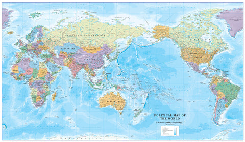
World Political National Geographic 1852 x 1219mm (Pacific Centred) Super Wall Map
$179.95
or make 4 interest-free payments of
$44.99 AUD
fortnightly with
![]() More info
More info
Pacific-Centred | Super Format – 1852 x 1219 mm | Elegant & Accurate | Available in Paper, Laminated, or Canvas
🌏 A Refined Vision of the World – With the Pacific at Its Heart
Reframe your understanding of global geography with this stunning Pacific-Centred World Political Wall Map by National Geographic. Presented in a grand 1852 x 1219 mm format, this map offers a visually balanced, elegant, and comprehensive view of the modern world—with the Pacific Ocean and surrounding continents at centre stage.
The traditional National Geographic aesthetic—subtle blue tones, shaded relief, and clean cartographic lines—makes this map a timeless and sophisticated feature in any home, classroom, executive boardroom, or planning space.
🔍 Key Features at a Glance
| Feature | Description |
|---|---|
| 🗺️ Projection | Winkel Tripel – balances area, direction, and distance with minimal distortion |
| 🌐 Orientation | Pacific-Centred – ideal for Oceania, Australasia, Asia-Pacific, and trans-Pacific trade routes |
| 📌 Political Boundaries | Clearly defined with colour-coded outlines; countries remain white for maximum legibility |
| ⛰️ Topography | Shaded relief enhances physical features such as mountain ranges and plateaus |
| 🌊 Oceanography | Includes ocean depth contours, currents, and undersea terrain such as trenches and ridges |
| 📊 Thematic Insets | Insets show global population density, vegetation zones, and land use patterns for broader insight |
🎨 Style & Aesthetic
Crafted in National Geographic’s iconic cartographic style, this map uses classic blue and earth-tone hues to convey a refined, scholarly look while ensuring maximum clarity and visual balance. It’s equally at home in traditional interiors or modern spaces.
📄 Format Options
Choose the material and finish that best suits your space and usage needs:
✦ Paper (160 gsm Premium Matte Stock)
-
Ideal for framing under glass
-
Matte surface with exceptional colour depth
-
Archival-quality and rollable for easy handling
✦ Laminated (Encapsulated Gloss Laminate)
-
Printed on premium stock and sealed with two layers of 80-micron gloss laminate
-
Wipe-clean surface – suitable for dry-erase markers
-
Durable and resistant to stains, creases, and moisture
-
Ideal for schools, collaborative workspaces, and frequent handling
✦ Canvas (395 gsm HP Matte Canvas)
-
Printed with fade-resistant, pigment-based inks
-
Museum-quality canvas texture for a tactile, artistic finish
-
Rich colour depth and long-lasting durability
-
Perfect for premium interior design or gallery-style display
🪵 Optional Timber Hanging System
Elevate your map’s presentation with our custom natural timber hang rails:
-
Smooth lacquered wooden battens attached top and bottom
-
A discreet cotton hanging cord for easy, elegant display
-
No framing required – simply hang on a single hook or nail
-
Available for both laminated and canvas versions
🕒 Please allow up to 10 business days for dispatch on hang-railed options as these are professionally fitted by hand.
📐 Specifications
| Attribute | Details |
|---|---|
| Map Title | World Political Wall Map (Pacific-Centred) |
| Publisher | National Geographic Society |
| Published | 2021 |
| Projection | Winkel Tripel |
| Scale | 1:22,445,000 |
| Size | 1852 mm (W) × 1219 mm (H) |
| Language | English |
| Print Method | Pigment-based, fade-resistant inks |
| Made In | Australia |
🎯 Who Is This Map For?
| 🎓 Educators | A powerful visual aid for geography and international studies |
| 🌍 Travellers & Planners | Ideal for tracking journeys or visualising global connections |
| 🏢 Professionals | Enhances boardrooms, coworking spaces, and strategic planning environments |
| 🖼️ Interior Designers | Adds elegance and intellect to any living or working space |
| 🎁 Gift Buyers | A thoughtful, visually stunning gift for map lovers and world explorers |
📦 Shipping & Delivery
-
Paper and laminated versions shipped rolled in a secure mailing tube
-
Canvas and hang-railed versions shipped flat or in reinforced tubes for protection
-
Made and dispatched from Australia
-
Hang-railed maps require up to 10 business days for custom assembly
🌐 See the World Through a Different Lens
The Pacific-Centred World Political Map by National Geographic offers a globally inclusive viewpoint and impeccable design—making it an essential reference, a captivating wall feature, and a conversation starter for years to come.
🛒 Add this stunning map to your cart today and bring global insight and timeless design into your space.


