- Australia ▾
- Topographic
▾
- Australia AUSTopo 250k (2025)
- Australia 50k Geoscience maps
- Australia 100k Geoscience maps
- Australia 250k Geoscience maps
- Australia 1:1m Geoscience maps
- New Zealand 50k maps
- New Zealand 250k maps
- New South Wales 25k maps
- New South Wales 50k maps
- New South Wales 100k maps
- Queensland 10k maps
- Queensland 25k maps
- Queensland 50k maps
- Queensland 100k maps
- Western Australia 25k maps
- Western Australia 50k maps
- Western Australia 100k maps
- Compasses
- Software
- GPS Systems
- International ▾
- Wall Maps
▾
- World
- Australia & New Zealand
- Countries, Continents & Regions
- Historical
- Vintage National Geographic
- Australian Capital Territory
- New South Wales
- Northern Territory
- Queensland
- South Australia
- Tasmania
- Victoria
- Western Australia
- Celestial
- Children's
- Mining & Resources
- Wine Maps
- Healthcare
- Postcode Maps
- Electoral Maps
- Nautical ▾
- Flags
▾
- Australian Flag Sets & Banners
- Flag Bunting
- Handwavers
- Australian National Flags
- Aboriginal Flags
- Torres Strait Islander Flags
- International Flags
- Flagpoles & Accessories
- Australian Capital Territory Flags
- New South Wales Flags
- Northern Territory Flags
- Queensland Flags
- South Australia Flags
- Tasmania Flags
- Victoria Flags
- Western Australia Flags
- Gifts ▾
- Globes ▾
Dear valued customer. Please note that our checkout is not supported by old browsers. Please use a recent browser to access all checkout capabilities


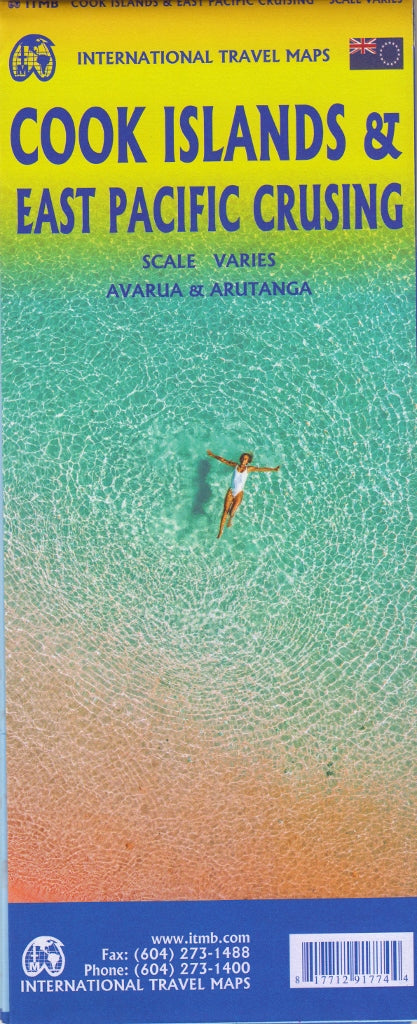
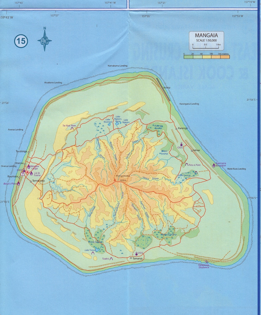
Cook Islands & East Pacific Cruising ITMB Map
$24.95
Afterpay is only available for orders between $50.00 and $1000.00 More info
Edition: Latest | Scale varies by region | Size: 685 mm × 990 mm | Double-Sided | ISBN: 9781553418136
🌴 Navigate the Idyllic South Pacific: From Island Paradise to Open-Ocean Adventure
This unique double-sided map by International Travel Maps (ITMB) blends two essential navigational tools into one thoughtfully designed product — ideal for cruise enthusiasts, island hoppers, tour operators, and anyone captivated by the South Pacific’s allure.
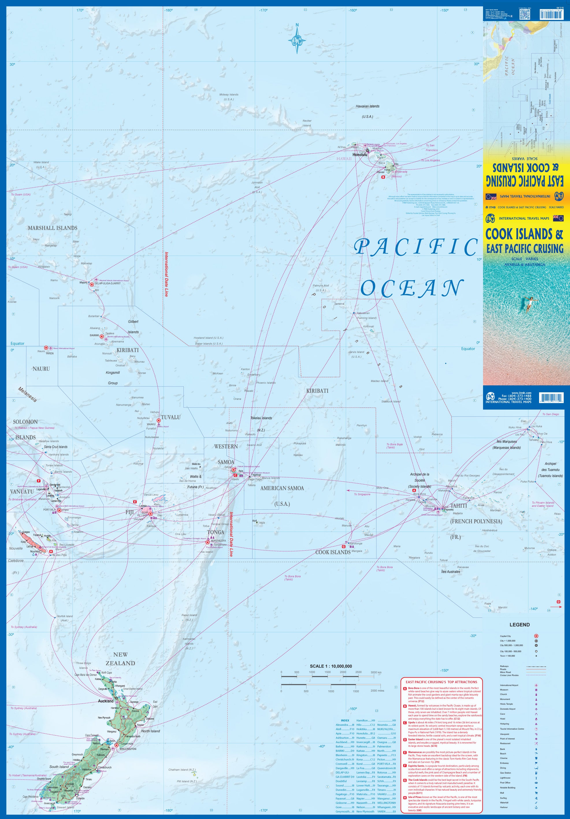
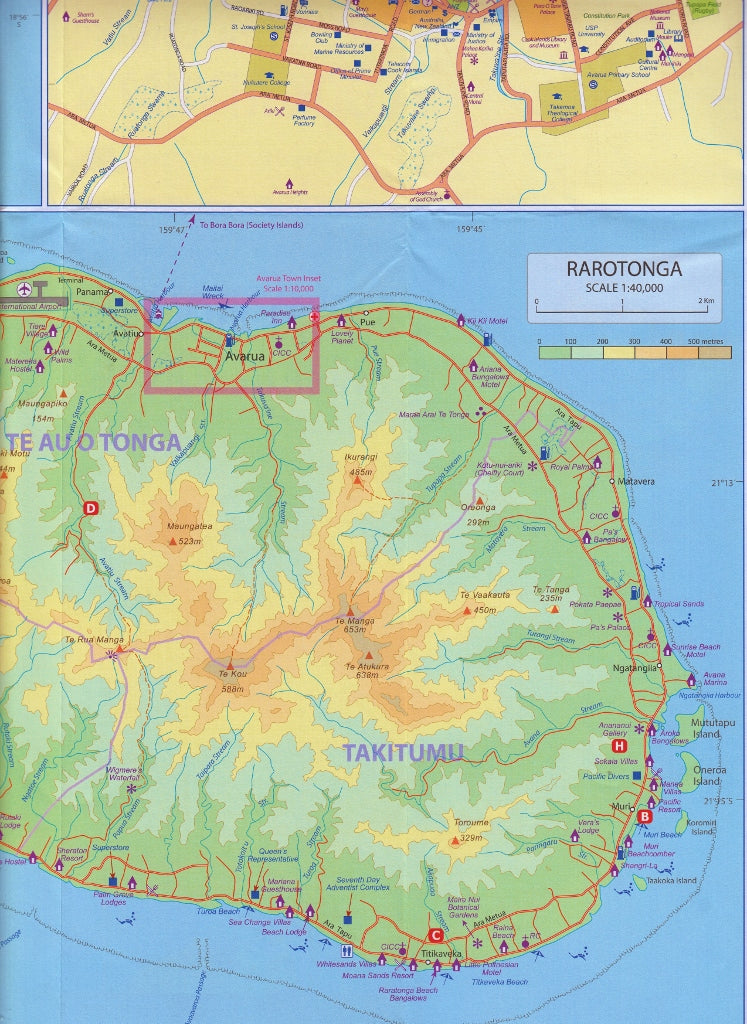
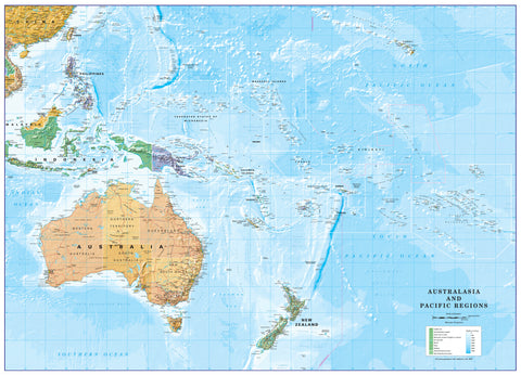
Side 1 focuses on the enchanting Cook Islands, offering highly detailed inset maps of key islands like Rarotonga, Aitutaki, Mangaia, and more. Side 2 broadens the perspective with a sweeping East Pacific Cruising Map, showcasing the major cruise routes across the tropical archipelagos — from Hawaii to Tahiti, Fiji to the Solomons, and down to New Zealand.
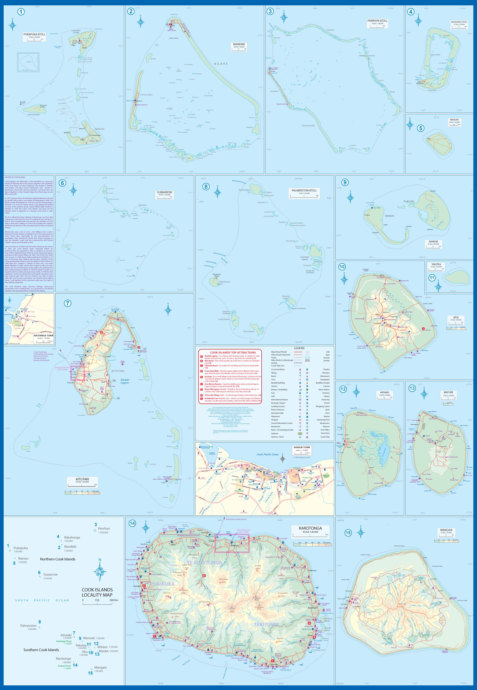
🔍 Side 1: The Cook Islands – In Detail
✅ Inset Island Maps
-
Includes Rarotonga, Aitutaki, Mangaia, Atiu, Mauke, Palmerston, Manihiki, and Penrhyn
-
Capital city Avarua and town Arutanga shown in detail
✅ Tourism-Oriented Design
-
Resorts, airstrips, harbours, and key travel infrastructure marked
-
Ideal for trip planning or showcasing destinations for tourism operators
✅ Clear Numbering & Legend
-
Fifteen distinct regions marked and labeled for easy reference
-
Colour-coded features and blue water routes for navigation
🌊 Side 2: East Pacific Cruising Map – Your Open-Ocean Companion
✅ Covers Vast Oceanic Geography
-
From the Marshall Islands and Solomons in the west
-
To Hawaii, French Polynesia (Tahiti) and Easter Island in the east
-
Includes Kiribati, Tuvalu, Samoa, Tonga, Fiji, New Caledonia, and more
✅ Cruise Routes Mapped
-
Shows key ocean cruising lanes across the Pacific basin
-
Perfect for following your ship’s route or planning multi-island adventures
✅ Elegant Oceanic Layout
-
Though island details are small, the beauty lies in the comprehensive overview
-
A lovely and decorative reference for cruise planners and enthusiasts alike
📐 Map Specifications
| Feature | Detail |
|---|---|
| Map Title | Cook Islands & East Pacific Cruising |
| Publisher | ITMB – International Travel Maps |
| Format | Folded, double-sided |
| Scale | Varies – Cook Islands (detailed), Pacific (broad) |
| Unfolded Size | 685 mm × 990 mm |
| Material | Paper (laminated option available) |
| ISBN | 9781553418136 |
🧭 Ideal For:
-
🛳️ Cruise Passengers & Agents – Follow your voyage and understand your route
-
🏝️ Island Explorers – Rarotonga, Aitutaki, and more in detail
-
🧳 Tour Operators – Showcase travel packages and resort locations
-
📚 Educators & Enthusiasts – A beautiful way to teach or display Pacific geography
-
🎁 Travel Gifts – Perfect for globetrotters and those who dream of South Pacific travel
💧 Laminated Version Available
We offer this map with optional high-gloss 80-micron lamination, allowing you to:
✔️ Mark locations with whiteboard marker
✔️ Apply map dots or labels
✔️ Protect against moisture, tears, and general wear
Note: Laminated maps are made to order — folded map is flattened and encapsulated, so original crease lines may be faintly visible.
📦 Shipping & Delivery
-
Ships from Australia
-
Standard and express shipping options available
Capture the spirit of the South Pacific – from tranquil lagoons to open-sea adventure – with this beautifully detailed and practical travel map.
Frequently Asked Questions
Where can I buy the Cook Islands & East Pacific Cruising ITMB Map?
The Cook Islands & East Pacific Cruising ITMB Map is available to buy online from Mapworld, Australia's largest map and geographic product retailer, with fast shipping Australia-wide.
Is the Cook Islands & East Pacific Cruising ITMB Map in stock at Mapworld?
Mapworld maintains extensive stock across its map range and aims for fast dispatch. Orders placed before 2pm AEST on business days are typically dispatched the same day, with standard and express Australia-wide delivery options available.
What is Mapworld's returns policy?
Mapworld accepts returns on undamaged items in original condition. Contact Mapworld within 90 days of purchase to arrange a return or exchange.
Does Mapworld ship the Cook Islands & East Pacific Cruising ITMB Map across Australia?
Yes, Mapworld ships Australia-wide. Standard shipping is a flat $7 rate, with free standard shipping on orders over $75. Express options are available at checkout. Most orders placed before 2pm AEST on weekdays are dispatched same day.
Related Items


© 2026 Mapworld. Website designed by Genie Media
X