- Australia ▾
- Topographic
▾
- Australia AUSTopo 250k (2025)
- Australia 50k Geoscience maps
- Australia 100k Geoscience maps
- Australia 250k Geoscience maps
- Australia 1:1m Geoscience maps
- New Zealand 50k maps
- New Zealand 250k maps
- New South Wales 25k maps
- New South Wales 50k maps
- New South Wales 100k maps
- Queensland 10k maps
- Queensland 25k maps
- Queensland 50k maps
- Queensland 100k maps
- Western Australia 25k maps
- Western Australia 50k maps
- Western Australia 100k maps
- Compasses
- Software
- GPS Systems
- International ▾
- Wall Maps
▾
- World
- Australia & New Zealand
- Countries, Continents & Regions
- Historical
- Vintage National Geographic
- Australian Capital Territory
- New South Wales
- Northern Territory
- Queensland
- South Australia
- Tasmania
- Victoria
- Western Australia
- Celestial
- Children's
- Mining & Resources
- Wine Maps
- Healthcare
- Postcode Maps
- Electoral Maps
- Nautical ▾
- Flags
▾
- Australian Flag Sets & Banners
- Flag Bunting
- Handwavers
- Australian National Flags
- Aboriginal Flags
- Torres Strait Islander Flags
- International Flags
- Flagpoles & Accessories
- Australian Capital Territory Flags
- New South Wales Flags
- Northern Territory Flags
- Queensland Flags
- South Australia Flags
- Tasmania Flags
- Victoria Flags
- Western Australia Flags
- Gifts ▾
- Globes ▾
Dear valued customer. Please note that our checkout is not supported by old browsers. Please use a recent browser to access all checkout capabilities


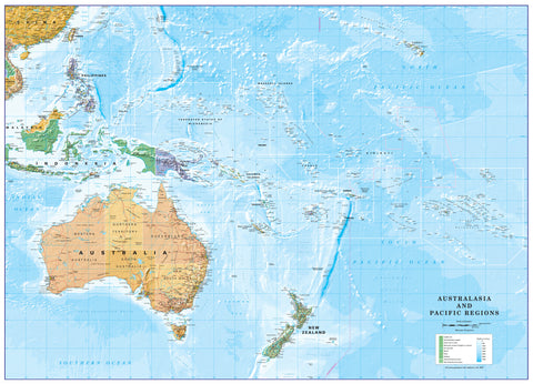
Oceania Atlas of the World, 11th Edition, National Geographic Wall Map
$69.95
or make 4 interest-free payments of
$17.49 AUD
fortnightly with
![]() More info
More info
🗺 Oceania Atlas of the World – 11th Edition
National Geographic Wall Map
Available in Standard & Supermap Sizes
Published: 2019
Made in Australia
🌏 The Oceanic World in Unparalleled Detail
Journey through the islands, nations, and seas of Oceania with this exceptional wall map from the cartographic masters at National Geographic.
From the bustling cities of Australia’s eastern seaboard to the remote coral atolls of Micronesia, the volcanic peaks of Papua New Guinea to the turquoise lagoons of French Polynesia, every feature has been captured in remarkable clarity.
This 11th Edition Atlas of the World map is more than just a reference tool — it is a visual celebration of Oceania’s geography, its cultural diversity, and its natural beauty.
Drawn with state-of-the-art cartographic techniques and presented with National Geographic’s signature aesthetic, it combines political accuracy with physical topography in a format that’s both educational and visually stunning.
📍 Key Cartographic Features
-
Comprehensive Political Boundaries – Clearly defined countries, territories, and state/province lines for all of Oceania.
-
Physical Geography – Shaded relief illustrating mountain ranges, volcanic peaks, coral atolls, and deep ocean trenches.
-
Major Cities & Towns – Capital cities, regional hubs, and smaller communities clearly labelled for easy reference.
-
Water Features – Includes oceans, seas, gulfs, bays, major rivers, and lagoons, with accurate naming and positioning.
-
Island Group Identification – All major island chains labelled, including Melanesia, Micronesia, and Polynesia.
-
Navigation-Friendly Projection – Drawn using the Transverse Mercator projection, highly regarded for nautical and aviation mapping.
-
Atlas Pedigree – Featured in the National Geographic 11th Edition World Atlas and now available as a stand-alone wall map.
📐 Size Options
| Size | Dimensions |
|---|---|
| Standard | 790 mm (W) × 610 mm (H) |
| Supermap | 1197 mm (W) × 915 mm (H) |
🖌 Premium Material & Display Options
| Format | Description |
|---|---|
| Paper (160 gsm) | Heavyweight matte-coated paper — ideal for framing under glass, offering a clean, professional finish. |
| Laminated | Fully encapsulated in two sheets of 80-micron gloss laminate — water-resistant, tear-proof, and compatible with non-permanent markers for note-taking and trip planning. |
| Laminated + Hang Rails | Laminated map mounted on natural timber rails with a matching hanging cord for instant display. |
| Canvas (395 gsm) | HP Professional Matte Canvas printed with archival pigment inks for exceptional UV resistance, colour depth, and an elegant, tactile surface. |
| Canvas + Hang Rails | Canvas map mounted on lacquered timber rails for a gallery-quality, vintage-style presentation. |
Please Note: Allow up to 10 working days for delivery of hang-railed maps, as each is professionally mounted by our custom framer.
🎯 Ideal For
-
Educational Spaces – Bring the geography of Oceania to life in classrooms and lecture halls.
-
Corporate & Professional Use – Perfect for travel agencies, government offices, shipping and maritime companies.
-
Home Decor – Adds intellectual charm and global style to living rooms, studies, or libraries.
-
Collectors – A must-have for map collectors and admirers of National Geographic’s iconic cartography.
-
Environmental Studies – Useful for understanding the relationship between Oceania’s landforms, climate, and ecosystems.
🌟 Why This Map Stands Out
-
Produced by National Geographic — synonymous with world-class mapping since 1915.
-
Combines political and physical mapping in one striking presentation.
-
Printed in Australia using fade-resistant pigment inks for longevity and colour accuracy.
-
Multiple display options to suit educational, professional, or decorative purposes.
-
Part of the celebrated 11th Edition World Atlas — recognised worldwide for its cartographic excellence.
🏝 Bring Oceania Into Focus
This map doesn’t just show where places are — it tells the story of a vast region scattered across the Pacific, bound by ocean currents and cultural connections. Whether used in a classroom to spark curiosity, in a corporate setting to inspire travel, or as a centrepiece in a home library, the Oceania Atlas of the World Wall Map is both a functional reference and a conversation piece.
Frequently Asked Questions
What does the Oceania Atlas of the World, 11th Edition, National Geographic Wall Map cover?
This atlas covers the geographic region indicated in the product title, including roads, towns, distances, and key travel information. Mapworld stocks atlases for Australian states and territories, 4WD regions, and international destinations.
Is this the latest edition?
Yes, this is the 11th Edition. Mapworld stocks the most current editions available from publishers.
Is this atlas or guide spiral bound?
Spiral binding is indicated in the product title where applicable. Spiral-bound atlases and guides lay flat when open, making them ideal for use in vehicles or on a table without needing to hold pages open.
Is the Oceania Atlas of the World, 11th Edition, National Geographic Wall Map in stock at Mapworld?
Mapworld maintains extensive stock across its map range and aims for fast dispatch. Orders placed before 2pm AEST on business days are typically dispatched the same day, with standard and express Australia-wide delivery options available.
Does Mapworld ship the Oceania Atlas of the World, 11th Edition, National Geographic Wall Map across Australia?
Yes, Mapworld ships Australia-wide. Standard shipping is a flat $7 rate, with free standard shipping on orders over $75. Express options are available at checkout. Most orders placed before 2pm AEST on weekdays are dispatched same day.
Related Items


© 2026 Mapworld. Website designed by Genie Media
X