- Australia ▾
- Topographic
▾
- Australia AUSTopo 250k (2024)
- Australia 50k Geoscience maps
- Australia 100k Geoscience maps
- Australia 250k Geoscience maps
- Australia 1.1m Geoscience maps
- New Zealand 50k maps
- New Zealand 250k maps
- New South Wales 25k maps
- New South Wales 50k maps
- New South Wales 100k maps
- Queensland 10k maps
- Queensland 25k maps
- Queensland 50k maps
- Queensland 100k maps
- Compasses
- Software
- GPS Systems
- Orienteering
- International ▾
- Wall Maps
▾
- World
- Australia & New Zealand
- Countries, Continents & Regions
- Historical
- Vintage National Geographic
- Australian Capital Territory
- New South Wales
- Northern Territory
- Queensland
- South Australia
- Tasmania
- Victoria
- Western Australia
- Celestial
- Children's
- Mining & Resources
- Wine Maps
- Healthcare
- Postcode Maps
- Electoral Maps
- Nautical ▾
- Flags
▾
- Australian Flag Sets & Banners
- Flag Bunting
- Handwavers
- Australian National Flags
- Aboriginal Flags
- Torres Strait Islander Flags
- International Flags
- Flagpoles & Accessories
- Australian Capital Territory Flags
- New South Wales Flags
- Northern Territory Flags
- Queensland Flags
- South Australia Flags
- Tasmania Flags
- Victoria Flags
- Western Australia Flags
- Gifts ▾
- Globes ▾
Dear valued customer. Please note that our checkout is not supported by old browsers. Please use a recent browser to access all checkout capabilities


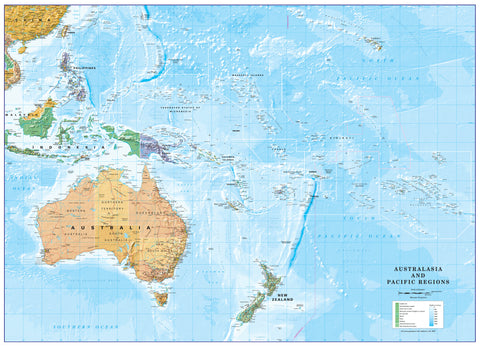
Pacific Ocean Hema 860 X 700mm Laminated Wall Map
$99.95
or make 4 interest-free payments of
$24.99 AUD
fortnightly with
![]() More info
More info
A Panoramic View of the World's Largest Ocean – From Australia to the Americas
Bring the vastness of the Pacific Ocean into focus with the Hema Pacific Ocean Laminated Wall Map—a beautifully designed and highly functional map that offers an expansive view of the largest and most significant body of water on Earth.
Spanning from Australia and New Zealand in the west to the Americas in the east, this detailed map captures the diverse geography of the Pacific Rim, including key island nations, strategic ocean currents, and major international borders. It is perfect for classrooms, offices, home study spaces, libraries, and travel planning areas.
This laminated edition is writeable and wipeable, allowing you to make notes, plan routes, or highlight points of interest using whiteboard markers. You can also use Mark-It Dots to track places visited or add educational annotations—making it both a beautiful display piece and a practical tool for anyone fascinated by geography, travel, or maritime history.
🌐 Coverage Includes:
-
Western Pacific: Australia, Papua New Guinea, Indonesia, Philippines, Japan, and East Asia
-
Central Pacific: Fiji, Samoa, Tahiti, Micronesia, Solomon Islands, Kiribati, Marshall Islands, and more
-
Eastern Pacific: West coasts of Canada, the United States, Mexico, Central America, and the Pacific coastline of South America, including Chile and Peru
-
Pacific Rim nations and key maritime routes
🧭 Key Features:
-
Laminated for Reusability
A gloss-laminated surface allows for use with whiteboard markers—simply write, plan, and wipe clean. -
Durable and Long-Lasting
The laminate coating protects the map from tears, moisture, and frequent handling, making it ideal for both home and classroom use. -
Ideal Size for Display
Measuring 860 mm wide x 700 mm high, this map is large enough to showcase fine detail, yet compact enough to fit comfortably in standard wall spaces. -
Highly Legible and Beautifully Designed
Featuring Hema’s signature cartographic style with clear country outlines, ocean shading, and vivid colour contrast for excellent readability and presentation. -
Mark-It-Dot Compatible
Easily track your travels, chart future journeys, or highlight historical and cultural regions. -
Designed by Hema Maps
Created by Australia’s leading map publisher with decades of trusted experience in high-quality cartography.
📐 Technical Details:
-
Scale: 1:24,000,000
-
Size: 860 mm (width) x 700 mm (height)
-
Finish: Gloss-laminated for erasable use
-
Print Type: Full colour with fine cartographic detail
-
Use: Wall-mounted, educational, travel planning, decorative
🎯 Perfect For:
-
Travellers & Adventurers – Ideal for those planning Pacific voyages, island-hopping journeys, or long-haul air routes
-
Teachers & Students – A visually engaging and informative tool for geography, history, or global studies
-
Home Decor Enthusiasts – A striking addition to a home office, library, or study nook
-
Maritime Professionals & Enthusiasts – Useful reference for yacht clubs, shipping routes, and navigators
-
Globally Curious Minds – For those who love exploring the world from their walls
🖼️ Display Tips:
-
Frame it for a polished gallery-style look
-
Use push pins or colour-coded stickers for tracking global journeys
-
Mount it in a study, classroom, travel agency, or on a feature wall
See the Pacific Like Never Before
With its unique east-west orientation and clear, beautifully printed layout, the Hema Pacific Ocean Laminated Wall Map transforms a wall into a panoramic window on the world. Whether you’re planning your next adventure or simply admiring the scope of Earth’s greatest ocean, this map is an essential visual companion for global thinkers and wanderers alike.