- Australia ▾
- Topographic
▾
- Australia AUSTopo 250k (2025)
- Australia 50k Geoscience maps
- Australia 100k Geoscience maps
- Australia 250k Geoscience maps
- Australia 1:1m Geoscience maps
- New Zealand 50k maps
- New Zealand 250k maps
- New South Wales 25k maps
- New South Wales 50k maps
- New South Wales 100k maps
- Queensland 10k maps
- Queensland 25k maps
- Queensland 50k maps
- Queensland 100k maps
- Western Australia 25k maps
- Western Australia 50k maps
- Western Australia 100k maps
- Compasses
- Software
- GPS Systems
- International ▾
- Wall Maps
▾
- World
- Australia & New Zealand
- Countries, Continents & Regions
- Historical
- Vintage National Geographic
- Australian Capital Territory
- New South Wales
- Northern Territory
- Queensland
- South Australia
- Tasmania
- Victoria
- Western Australia
- Celestial
- Children's
- Mining & Resources
- Wine Maps
- Healthcare
- Postcode Maps
- Electoral Maps
- Nautical ▾
- Flags
▾
- Australian Flag Sets & Banners
- Flag Bunting
- Handwavers
- Australian National Flags
- Aboriginal Flags
- Torres Strait Islander Flags
- International Flags
- Flagpoles & Accessories
- Australian Capital Territory Flags
- New South Wales Flags
- Northern Territory Flags
- Queensland Flags
- South Australia Flags
- Tasmania Flags
- Victoria Flags
- Western Australia Flags
- Gifts ▾
- Globes ▾
Dear valued customer. Please note that our checkout is not supported by old browsers. Please use a recent browser to access all checkout capabilities


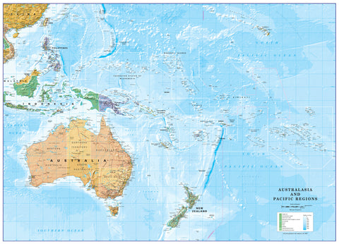
Islands of the Pacific - Atlas of the World, 11th Edition by National Geographic
$69.95
or make 4 interest-free payments of
$17.49 AUD
fortnightly with
![]() More info
More info
Inset Wall Map Collection | Pacific Nations in Detail | Atlas of the World, 11th Edition (798 × 610 mm) | Premium Finishes
A beautifully structured overview of the world’s largest ocean, Islands of the Pacific presents the vast Pacific region through a series of detailed inset maps. Published by National Geographic as part of the Atlas of the World, 11th Edition (Plate 110), this map showcases 54 island nations and territories with clarity, precision, and refined cartographic design.
From Micronesia to Polynesia and Melanesia, it transforms an immense and scattered geography into an accessible, highly readable visual reference.
Why This Map Stands Out
54 island nations in one map
Each island group is presented in its own inset for maximum clarity and detail.
Atlas-quality cartography
Drawn using advanced techniques for accuracy and balance.
Physical and political detail combined
Shows terrain, coastlines, and elevation alongside boundaries and settlements.
Exceptional readability
Clean layout and carefully placed labels ensure ease of use.
A complete Pacific reference
Brings together a vast and dispersed region into one coherent view.
🗺️ What the Map Shows
- Inset maps of 54 Pacific island nations and territories
- Coverage across the major Pacific regions:
- Micronesia
- Melanesia
- Polynesia
- Individual island groups shown in high detail
- Political boundaries, settlements, and key locations
- Physical features including coastlines, reefs, and terrain
- A clear overview of how islands are distributed across the Pacific Ocean
📐 Size & Format
798 mm (W) × 610 mm (H)
Landscape orientation
A large, information-rich format ideal for:
- Classrooms and geography education
- Offices and research environments
- Travel planning and regional reference
- Interiors inspired by ocean and island geography
✨ Premium Finishes
| Format | Description |
|---|---|
| 📜 Paper (160 gsm) | Heavyweight matte-coated paper—ideal for framing. Preserves clarity across all insets. |
| 🧼 Laminated (Encapsulated) | Sealed in 2 × 80-micron gloss laminate. Durable, wipe-clean, and perfect for teaching environments. |
| 🪵 Laminated + Timber Hang Rails | Laminated map mounted with lacquered natural timber rails and hanging cord—ready to display. |
| 🖼️ Canvas (395 gsm HP Professional Matte) | Printed with archival pigment inks. Enhances colour depth and presentation. |
| 🪵 Canvas + Timber Hang Rails | Canvas paired with timber rails for a refined, gallery-style presentation. |
🔨 Please allow up to 10 working days for professionally mounted hang-railed finishes.
📊 Specifications
| Feature | Detail |
|---|---|
| Title | Islands of the Pacific |
| Publisher | National Geographic |
| Published | 2019 |
| Source | Atlas of the World, 11th Edition (Plate 110) |
| Dimensions | 798 mm × 610 mm |
| Orientation | Landscape |
| Map Type | Political / Physical (Inset Collection) |
| Coverage | Pacific Ocean island nations |
| Collections | Oceans |
| Materials | 160 gsm matte paper / 2 × 80-micron laminate / 395 gsm HP Professional Matte Canvas |
| Printing | Pigment-based, fade-resistant inks |
| Origin | Printed in Australia |
🎯 Ideal For
- Students and educators of Pacific geography
- Travellers and planners exploring island destinations
- Collectors of National Geographic atlas maps
- Offices needing a comprehensive regional reference
- Gift buyers seeking a detailed and visually engaging map
🌊 A Vast Ocean, Made Understandable
The Pacific is immense—yet this map makes it approachable:
- Thousands of islands scattered across vast distances
- Unique cultures shaped by ocean, isolation, and connection
- Diverse landscapes from coral atolls to volcanic peaks
- A region defined by both distance and interconnection
This map brings that complexity together—offering a clear and compelling view of the Pacific’s island world.
🤝 Our Commitment
- Printed in Australia using archival-quality production
- Faithfully reproduced to preserve clarity and fine detail
- Premium materials selected for durability and long-term display
- Each map is hand-checked before dispatch
- Carefully packaged for safe delivery
🚚 Delivery
- Paper, Laminated, Canvas (rolled): Dispatch within 1–2 business days
- Hang-Railed Maps: Made to order—allow up to 10 working days
- Packaging: Securely rolled in protective tubing
Explore the world’s greatest ocean—one island at a time—
a map that brings the Pacific into sharp, detailed focus.
👉 Order now and add a complete Pacific reference to your wall.
Frequently Asked Questions
What does the Islands of the Pacific - Atlas of the World, 11th Edition by National cover?
This atlas covers the geographic region indicated in the product title, including roads, towns, distances, and key travel information. Mapworld stocks atlases for Australian states and territories, 4WD regions, and international destinations.
Is this the latest edition?
Yes, this is the 11th Edition. Mapworld stocks the most current editions available from publishers.
Is this atlas or guide spiral bound?
Spiral binding is indicated in the product title where applicable. Spiral-bound atlases and guides lay flat when open, making them ideal for use in vehicles or on a table without needing to hold pages open.
Is the Islands of the Pacific - Atlas of the World, 11th Edition by National in stock at Mapworld?
Mapworld maintains extensive stock across its map range and aims for fast dispatch. Orders placed before 2pm AEST on business days are typically dispatched the same day, with standard and express Australia-wide delivery options available.
Does Mapworld ship the Islands of the Pacific - Atlas of the World, 11th Edition by National across Australia?
Yes, Mapworld ships Australia-wide. Standard shipping is a flat $7 rate, with free standard shipping on orders over $75. Express options are available at checkout. Most orders placed before 2pm AEST on weekdays are dispatched same day.
Related Items


© 2026 Mapworld. Website designed by Genie Media
X