- Australia ▾
- Topographic
▾
- Australia AUSTopo 250k (2025)
- Australia 50k Geoscience maps
- Australia 100k Geoscience maps
- Australia 250k Geoscience maps
- Australia 1:1m Geoscience maps
- New Zealand 50k maps
- New Zealand 250k maps
- New South Wales 25k maps
- New South Wales 50k maps
- New South Wales 100k maps
- Queensland 10k maps
- Queensland 25k maps
- Queensland 50k maps
- Queensland 100k maps
- Western Australia 25k maps
- Western Australia 50k maps
- Western Australia 100k maps
- Compasses
- Software
- GPS Systems
- International ▾
- Wall Maps
▾
- World
- Australia & New Zealand
- Countries, Continents & Regions
- Historical
- Vintage National Geographic
- Australian Capital Territory
- New South Wales
- Northern Territory
- Queensland
- South Australia
- Tasmania
- Victoria
- Western Australia
- Celestial
- Children's
- Mining & Resources
- Wine Maps
- Healthcare
- Postcode Maps
- Electoral Maps
- Nautical ▾
- Flags
▾
- Australian Flag Sets & Banners
- Flag Bunting
- Handwavers
- Australian National Flags
- Aboriginal Flags
- Torres Strait Islander Flags
- International Flags
- Flagpoles & Accessories
- Australian Capital Territory Flags
- New South Wales Flags
- Northern Territory Flags
- Queensland Flags
- South Australia Flags
- Tasmania Flags
- Victoria Flags
- Western Australia Flags
- Gifts ▾
- Globes ▾
Dear valued customer. Please note that our checkout is not supported by old browsers. Please use a recent browser to access all checkout capabilities


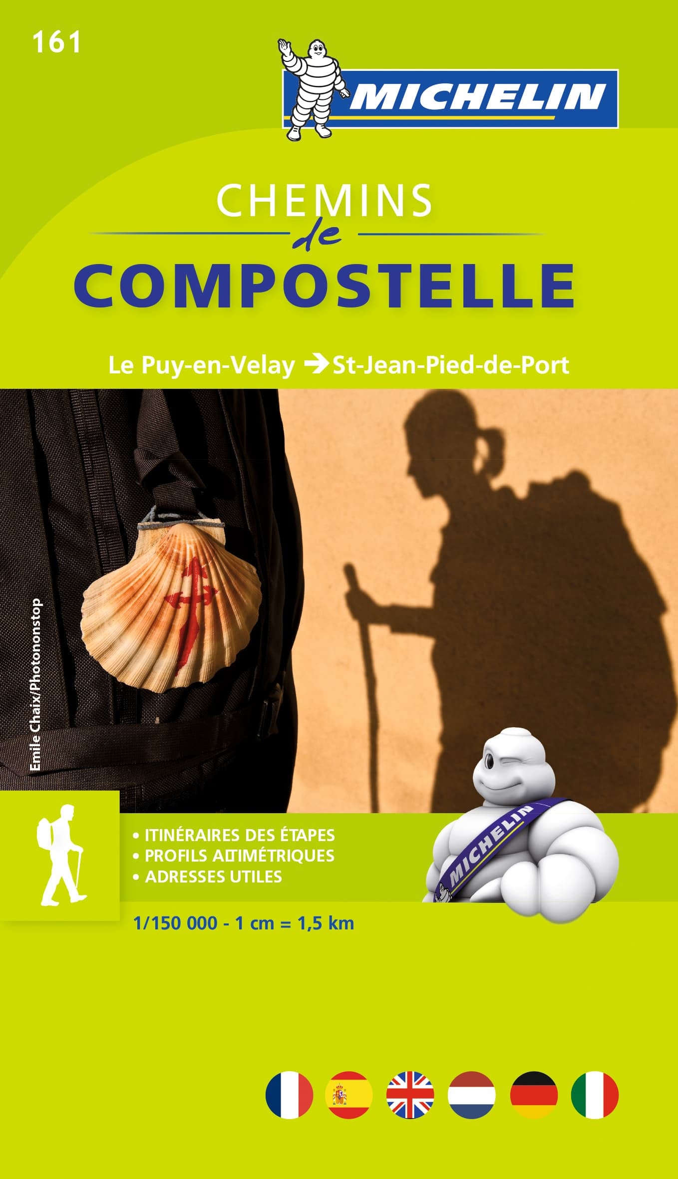

Way of St James France - Chemins de Compostelle Map Book Michelin 161
$21.95
Afterpay is only available for orders between $50.00 and $1000.00 More info
Michelin Map Book 161 | From Le Puy-en-Velay to Saint-Jean-Pied-de-Port
Scale: 1:150,000 (1 cm = 1.5 km)
Size: 200 mm x 110 mm | Format: Spiral-bound Booklet
🇫🇷 Your Pilgrimage Companion Across Southern France
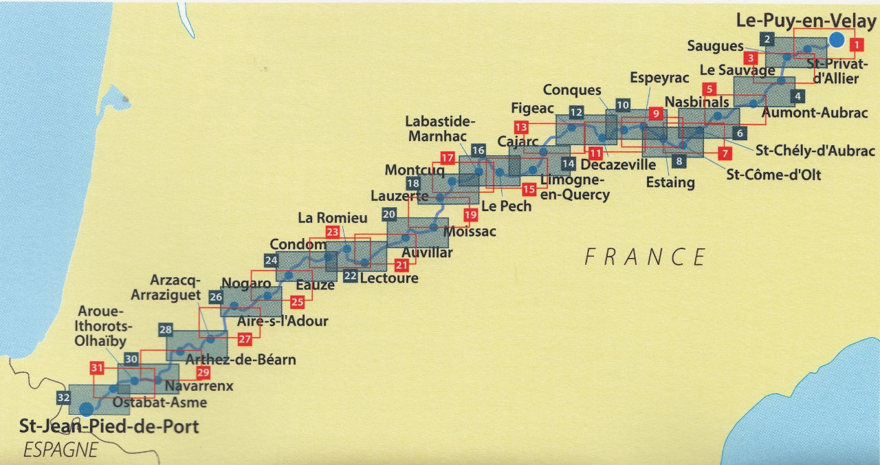
Part of an outstanding two-volume series by Michelin, this Chemins de Compostelle map book is your essential companion for walking the French section of the historic Way of St James (Via Podiensis). Spanning from Le Puy-en-Velay to Saint-Jean-Pied-de-Port, this beautifully presented book provides detailed topographic mapping, altitude profiles, and key town plans—designed specifically with pilgrims in mind.
🗺️ Coverage Highlights
-
Start: Le Puy-en-Velay (Haute-Loire)
-
Finish: Saint-Jean-Pied-de-Port (Pyrénées-Atlantiques)
-
Covers all stages of the Via Podiensis (GR 65), including:
-
Aumont-Aubrac
-
Conques
-
Cahors
-
Moissac
-
Aire-sur-l’Adour
-
Navarrenx and beyond
-
Whether you’re walking for a week or the entire route, this book offers complete leg-by-leg coverage with all the planning tools you need.
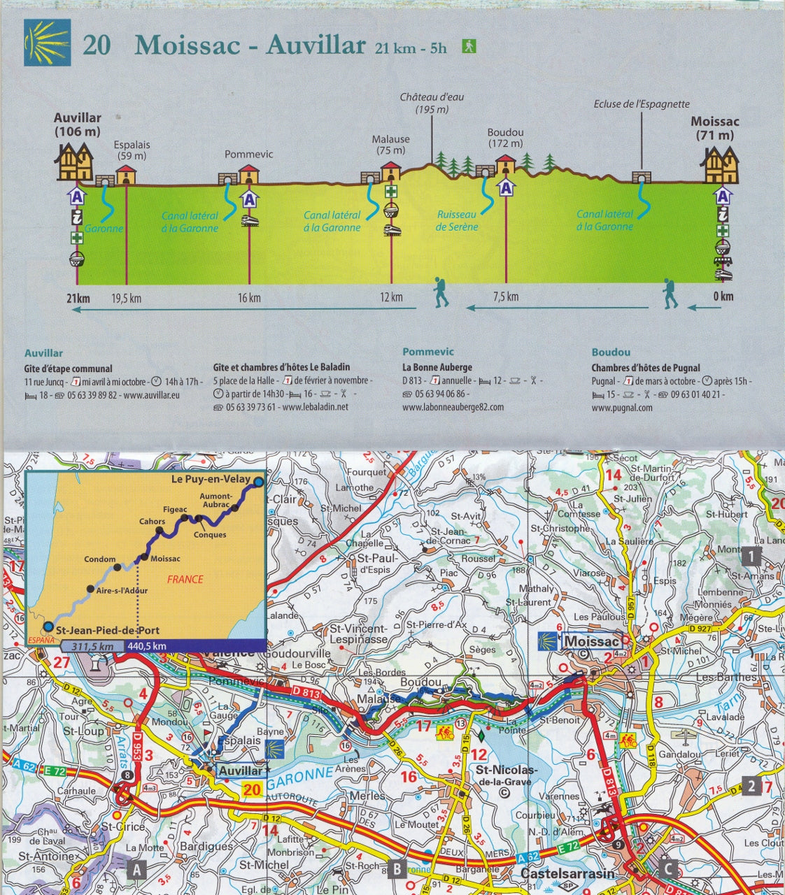
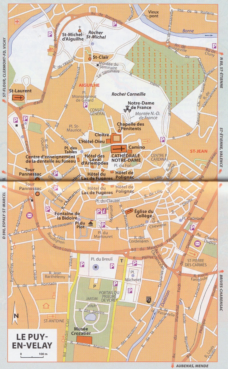
📘 What’s Inside?
| Feature | Description |
|---|---|
| 🗺 Topographic Maps | Clearly marked GR paths, secondary routes & terrain details |
| 📈 Altitude Profiles | Elevation data for each leg—perfect for daily planning |
| 🏘 Town Maps | Detailed layouts of major pilgrim stops for orientation |
| 📍 Place Name Index | Quick-reference for towns, villages & waypoints |
| 📏 1:150,000 Scale | Ideal balance of clarity and coverage (1 cm = 1.5 km) |
| 💼 Compact Size | Easily fits into a daypack (200 mm x 110 mm) |
🧭 Why This Book?
✅ Pilgrim-Proven – Created specifically for walkers of the Camino Francés, this guide is designed with practical daily use in mind.
✅ Weather-Resistant Pages – Slightly coated paper helps protect from damp hands, light drizzle, and trail dust.
✅ Reliable – Produced by Michelin, one of Europe’s most respected cartographic publishers.
✅ User-Tested – Here’s what one walker had to say:
"I’ve personally walked over 200 km of the Chemin and can confidently say this book is a true gem. It’s intuitive, reliable, and light enough to carry every day without hesitation."
📦 Complete the Set
Pair it with Michelin Map Book 160 – Camino de Santiago (Spain) to continue your journey from Saint-Jean-Pied-de-Port to Santiago de Compostela.
✨ Ideal For:
-
Pilgrims walking the GR 65 (Via Podiensis)
-
Camino first-timers & seasoned veterans
-
Long-distance walkers, spiritual travellers, and history lovers
-
Route planners and armchair travellers alike
📚 Specifications
| Attribute | Details |
|---|---|
| Title | Chemins de Compostelle |
| Publisher | Michelin |
| Series | Map Book 161 |
| Scale | 1:150,000 |
| Format | Spiral-bound book |
| Size | 200 mm x 110 mm |
| Weight | Lightweight & pack-friendly |
| Edition | Latest available |
| Language | Map key in multiple languages, including English |
| Coverage | Le Puy-en-Velay to St-Jean-Pied-de-Port |
Embarking on the Way of St James is a journey of both outer discovery and inner reflection. This compact, beautifully illustrated Michelin map book is the one guide you’ll reach for every morning on the trail.
Lightweight, trustworthy, and designed with pilgrims in mind—this is a must-have for anyone setting foot on the French Camino.
Frequently Asked Questions
Where can I buy the Way of St James France - Chemins de Compostelle Map Book Michelin 161?
The Way of St James France - Chemins de Compostelle Map Book Michelin 161 is available to buy online from Mapworld, Australia's largest map and geographic product retailer, with fast shipping Australia-wide.
Is the Way of St James France - Chemins de Compostelle Map Book Michelin 161 in stock at Mapworld?
Mapworld maintains extensive stock across its map range and aims for fast dispatch. Orders placed before 2pm AEST on business days are typically dispatched the same day, with standard and express Australia-wide delivery options available.
What is Mapworld's returns policy?
Mapworld accepts returns on undamaged items in original condition. Contact Mapworld within 90 days of purchase to arrange a return or exchange.
Does Mapworld ship the Way of St James France - Chemins de Compostelle Map Book Michelin 161 across Australia?
Yes, Mapworld ships Australia-wide. Standard shipping is a flat $7 rate, with free standard shipping on orders over $75. Express options are available at checkout. Most orders placed before 2pm AEST on weekdays are dispatched same day.
Related Items


© 2026 Mapworld. Website designed by Genie Media
X