- Australia ▾
- Topographic
▾
- Australia AUSTopo 250k (2025)
- Australia 50k Geoscience maps
- Australia 100k Geoscience maps
- Australia 250k Geoscience maps
- Australia 1:1m Geoscience maps
- New Zealand 50k maps
- New Zealand 250k maps
- New South Wales 25k maps
- New South Wales 50k maps
- New South Wales 100k maps
- Queensland 10k maps
- Queensland 25k maps
- Queensland 50k maps
- Queensland 100k maps
- Western Australia 25k maps
- Western Australia 50k maps
- Western Australia 100k maps
- Compasses
- Software
- GPS Systems
- International ▾
- Wall Maps
▾
- World
- Australia & New Zealand
- Countries, Continents & Regions
- Historical
- Vintage National Geographic
- Australian Capital Territory
- New South Wales
- Northern Territory
- Queensland
- South Australia
- Tasmania
- Victoria
- Western Australia
- Celestial
- Children's
- Mining & Resources
- Wine Maps
- Healthcare
- Postcode Maps
- Electoral Maps
- Nautical ▾
- Flags
▾
- Australian Flag Sets & Banners
- Flag Bunting
- Handwavers
- Australian National Flags
- Aboriginal Flags
- Torres Strait Islander Flags
- International Flags
- Flagpoles & Accessories
- Australian Capital Territory Flags
- New South Wales Flags
- Northern Territory Flags
- Queensland Flags
- South Australia Flags
- Tasmania Flags
- Victoria Flags
- Western Australia Flags
- Gifts ▾
- Globes ▾
Dear valued customer. Please note that our checkout is not supported by old browsers. Please use a recent browser to access all checkout capabilities


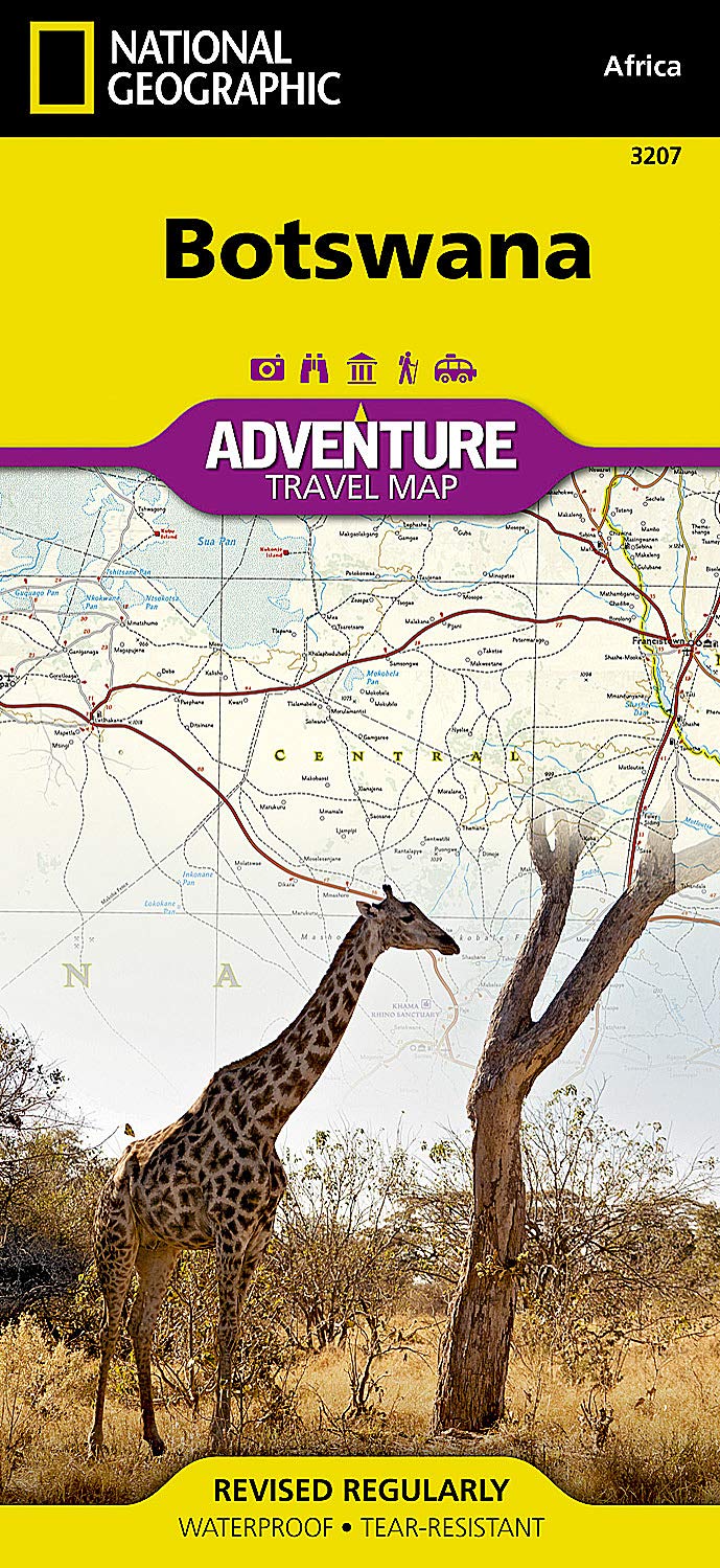
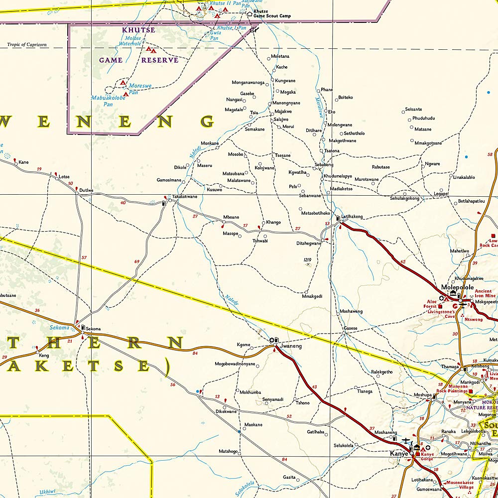
Botswana National Geographic Folded Map
$27.95
Afterpay is only available for orders between $50.00 and $1000.00 More info
🇧🇼 Durable | Waterproof | Tear-Resistant | Expertly Researched
Explore the vast wilderness, dramatic salt pans, and legendary wildlife reserves of Botswana with the National Geographic Adventure Map – a high-detail, field-tested resource perfect for travelers, conservationists, and safari enthusiasts alike.
Crafted for those venturing beyond the guidebook, this map blends precision cartography with National Geographic's trusted style, making it a reliable tool for trip planning, navigation, and on-the-ground adventure.
🗺️ Map Coverage & Regions Highlighted
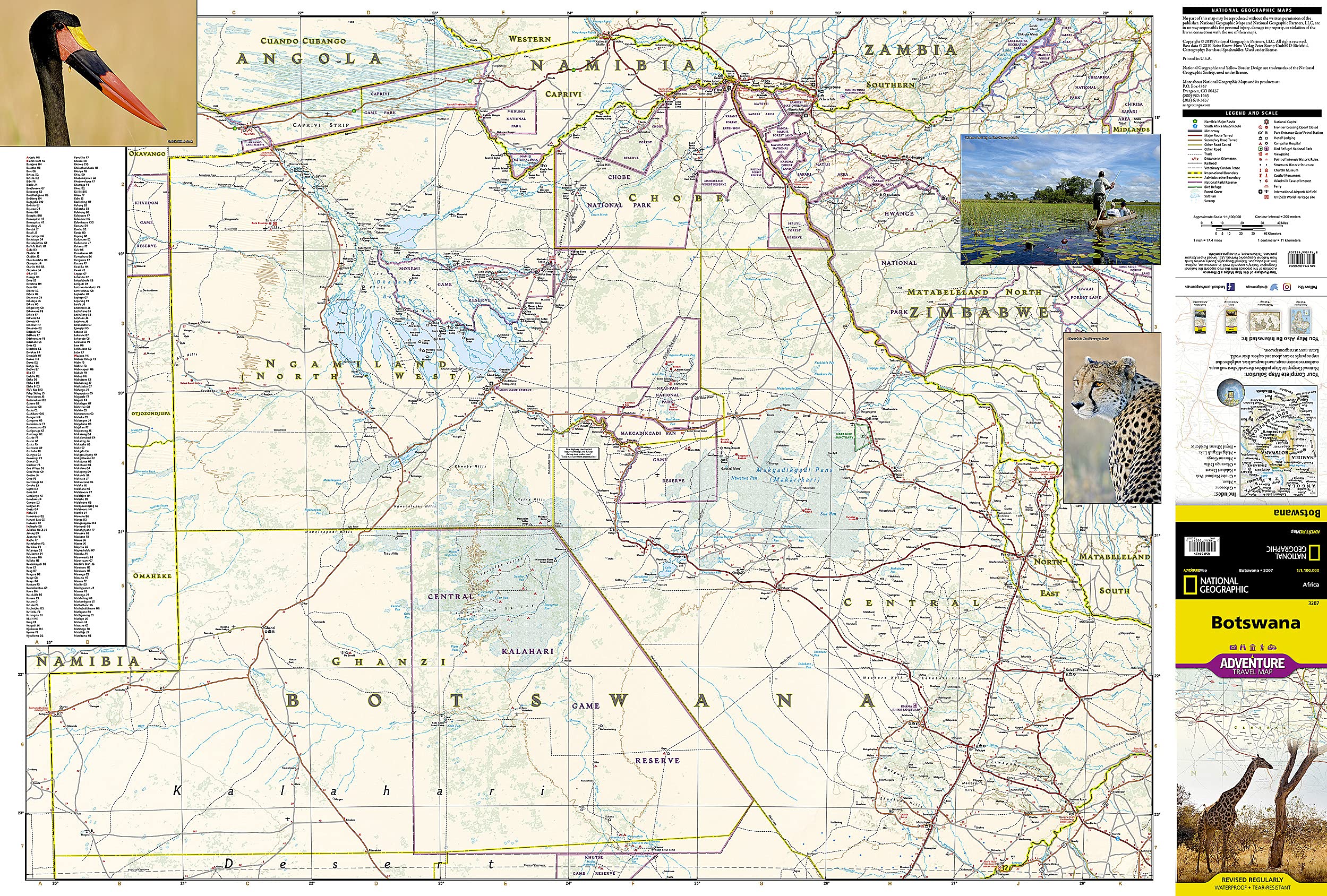
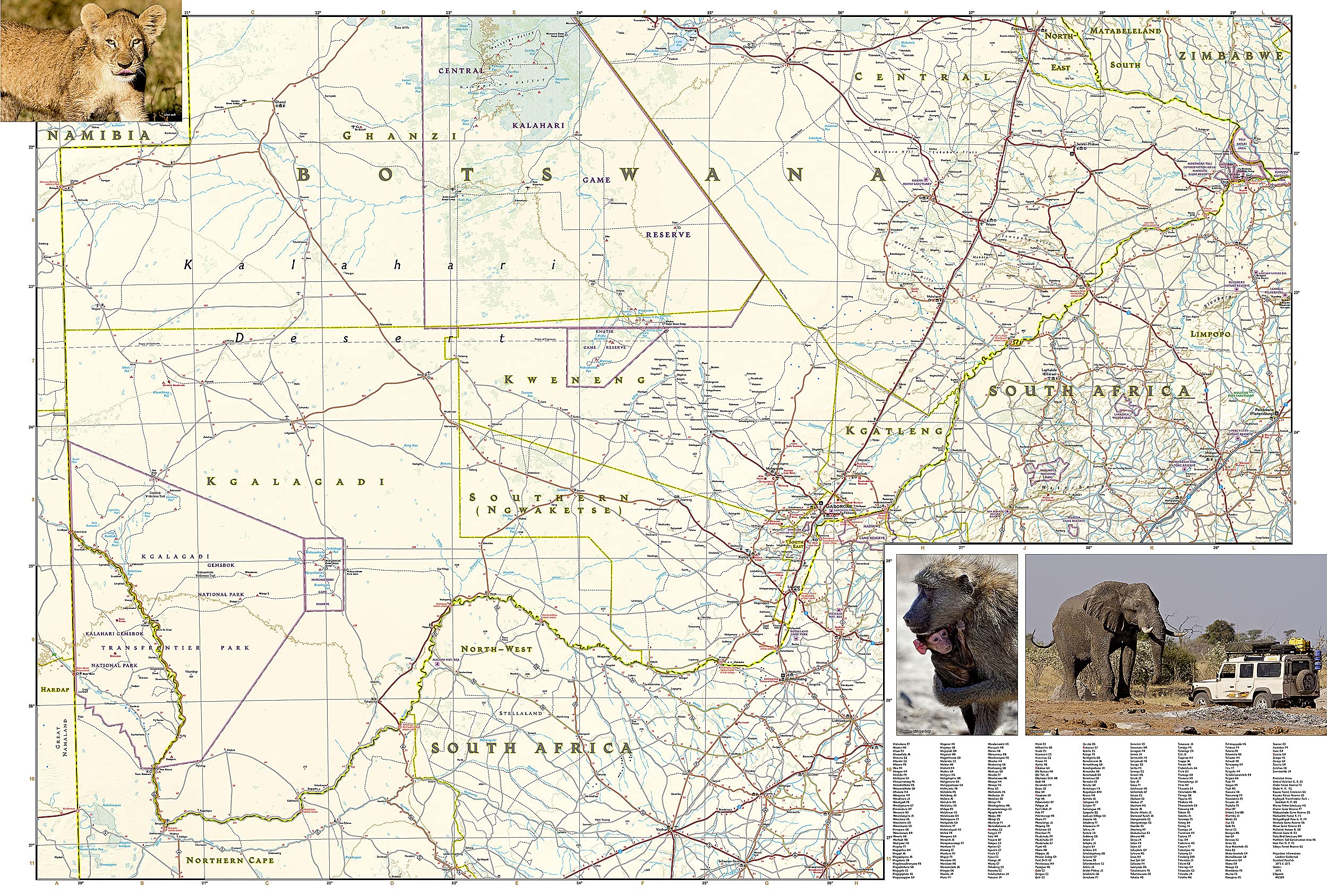
This double-sided map provides comprehensive coverage of Botswana and adjacent areas of Namibia, Zambia, Zimbabwe, and South Africa — ideal for trans-frontier trips and extended regional safaris.
Front Side Highlights:
-
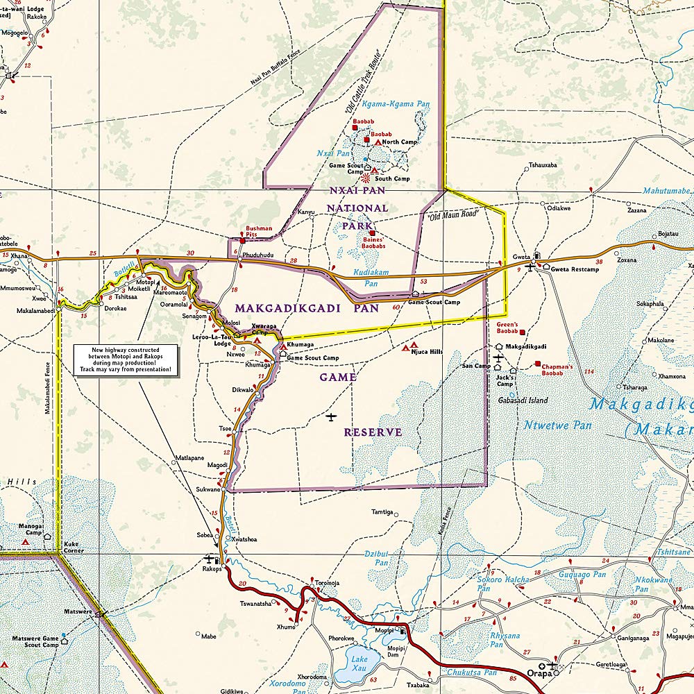
🐘 Chobe National Park & Nxai-Pan National Park
-
🦁 Moremi Game Reserve and the lush Okavango Delta
-
🌍 UNESCO Sites: Tsodilo Hills & Makgadikgadi Pans
-
💦 Caprivi Strip and the iconic Victoria Falls
-
🌳 Forest cover, swamps, salt pans & scenic viewpoints
Reverse Side Highlights:
-
🐾 Central Kalahari & Khutse Game Reserves
-
🦏 Khama Rhino Sanctuary and Kgalagadi Transfrontier Park
-
🐆 Gemsbok National Park
-
🏙️ Gaborone (capital city) with urban detail
🧭 Map Features
-
✅ Scale: 1:1,100,000 — perfect for regional travel planning and on-the-ground exploration
-
🛣️ Road Network: Includes highways, secondary roads, remote tracks, and 4WD routes
-
✈️ Transport Links: Airports, airfields, rail lines, and international border crossings
-
🏕️ Points of Interest: Campsites, monuments, historic ruins, churches, national parks, and reserves
-
📍 Indexed Locations: Towns, villages, and protected areas for fast look-up
-
🌍 Terrain Representation: Forests, swamps, rivers, salt pans, and elevation shading
-
🌄 Includes UNESCO World Heritage Sites and ecotourism highlights
🛡️ Durability & Material
This Adventure Map is printed on tough synthetic paper, designed to withstand real-world travel:
-
💧 Waterproof
-
✋ Tear-resistant
-
🌿 Lightweight yet rugged – built for safari travel, outdoor exploration, and humid environments
📐 Specifications
| Feature | Detail |
|---|---|
| Map Title | Botswana Adventure Map |
| Publisher | National Geographic |
| Map Format | Folded, Double-sided |
| Scale | 1:1,100,000 |
| Sheet Size | 959 mm (w) × 648 mm (h) |
| Folded Size | Approx. 108 mm × 235 mm |
| Material | Waterproof & tear-resistant synthetic paper |
🌍 Why Choose This Map?
-
🦓 Ideal for safaris, overland tours, and national park visits
-
🗺️ Trusted cartography from National Geographic
-
🎒 Folds easily for daypack storage or dashboard use
-
📚 Perfect for trip planning, educational use, or as a souvenir for map lovers
🧳 Recommended For:
-
Wildlife enthusiasts & photographers
-
Overland travelers & self-drive explorers
-
Tour guides, researchers, and students of geography
-
Eco-tourists heading to the Okavango Delta, Chobe, or the Kalahari
Whether you're navigating the watery maze of the Okavango, tracking elephants in Chobe, or heading deep into the silence of the Central Kalahari, this map is the perfect companion for a Botswana adventure.
Frequently Asked Questions
What area does the Botswana National Geographic Folded Map cover?
The Botswana National Geographic Folded Map provides road coverage of the region named in the product title. The map covers major cities, highways, towns, and regional roads, with inset city maps for key urban centres where applicable.
Is the Botswana National Geographic Folded Map up to date?
Yes, this is the current edition. Mapworld stocks the most current editions from all major publishers, updated to reflect new roads and infrastructure.
What size is this map when unfolded?
Folded maps from Mapworld's range are compact and portable. Most standard folded road or travel maps open to between A1 (594 × 841mm) and A0 (841 × 1189mm) when fully unfolded, and fold down to approximately A4 or smaller for easy storage in a glove box, bag, or backpack.
Is the Botswana National Geographic Folded Map in stock at Mapworld?
Mapworld maintains extensive stock across its map range and aims for fast dispatch. Orders placed before 2pm AEST on business days are typically dispatched the same day, with standard and express Australia-wide delivery options available.
Does Mapworld ship the Botswana National Geographic Folded Map across Australia?
Yes, Mapworld ships Australia-wide. Standard shipping is a flat $7 rate, with free standard shipping on orders over $75. Express options are available at checkout. Most orders placed before 2pm AEST on weekdays are dispatched same day.
Related Items


© 2026 Mapworld. Website designed by Genie Media
X