- Australia ▾
- Topographic
▾
- Australia AUSTopo 250k (2025)
- Australia 50k Geoscience maps
- Australia 100k Geoscience maps
- Australia 250k Geoscience maps
- Australia 1:1m Geoscience maps
- New Zealand 50k maps
- New Zealand 250k maps
- New South Wales 25k maps
- New South Wales 50k maps
- New South Wales 100k maps
- Queensland 10k maps
- Queensland 25k maps
- Queensland 50k maps
- Queensland 100k maps
- Western Australia 25k maps
- Western Australia 50k maps
- Western Australia 100k maps
- Compasses
- Software
- GPS Systems
- International ▾
- Wall Maps
▾
- World
- Australia & New Zealand
- Countries, Continents & Regions
- Historical
- Vintage National Geographic
- Australian Capital Territory
- New South Wales
- Northern Territory
- Queensland
- South Australia
- Tasmania
- Victoria
- Western Australia
- Celestial
- Children's
- Mining & Resources
- Wine Maps
- Healthcare
- Postcode Maps
- Electoral Maps
- Nautical ▾
- Flags
▾
- Australian Flag Sets & Banners
- Flag Bunting
- Handwavers
- Australian National Flags
- Aboriginal Flags
- Torres Strait Islander Flags
- International Flags
- Flagpoles & Accessories
- Australian Capital Territory Flags
- New South Wales Flags
- Northern Territory Flags
- Queensland Flags
- South Australia Flags
- Tasmania Flags
- Victoria Flags
- Western Australia Flags
- Gifts ▾
- Globes ▾
Dear valued customer. Please note that our checkout is not supported by old browsers. Please use a recent browser to access all checkout capabilities


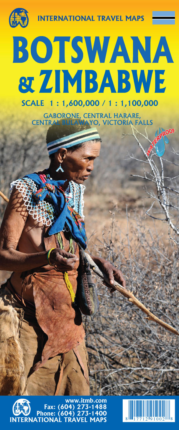
Botswana & Zimbabwe ITMB Map
$24.95
Afterpay is only available for orders between $50.00 and $1000.00 More info
Scales: Botswana 1:1,600,000 / Zimbabwe 1:1,000,000 | Size: 680 mm x 990 mm
Printed on Waterproof, Tear-Resistant Stone Paper | Optional Lamination Available
Explore two of Southern Africa’s most compelling and contrasting countries with this detailed double-sided travel map by International Travel Maps (ITMB). Now in its 7th edition (2020), this map covers Botswana and Zimbabwe—neighbours in geography and colonial heritage, but vastly different in modern development and travel experience.
Printed on durable waterproof stone paper, this map is built for real-world adventure, from the remote plains of the Kalahari Desert to the misty edge of Victoria Falls.
✅ Key Features & Benefits
🗺️ Double-Sided Coverage of Two Key African Nations
-
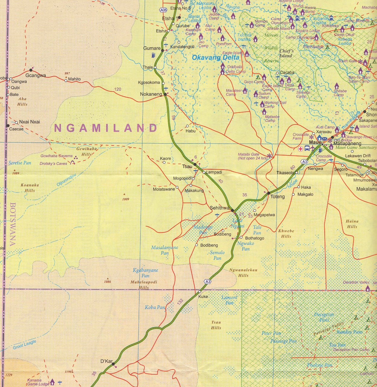
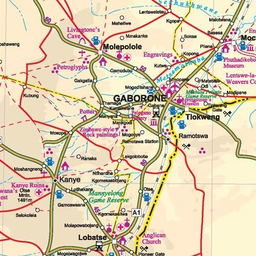
Side A: Botswana – One of Africa’s safest and most stable nations, this side focuses on:
-
Major roadways and park access routes
-
National parks including the Okavango Delta, Chobe National Park, and Central Kalahari Game Reserve
-
Inset map of Gaborone, the capital city
-
Tourist hotspots such as Maun, the primary access point for safari adventures
-
-
Side B: Zimbabwe – A country rich in heritage and natural beauty, with:
-
Harare, Bulawayo, Victoria Falls, and the Great Zimbabwe Ruins shown in dedicated insets
-
Road and rail networks (note: some road conditions may vary)
-
Major game parks, lakes, and historical landmarks
-
🌍 Ideal for Safari Planners & Independent Travellers
From wildlife safaris in Botswana to cultural heritage sites in Zimbabwe, this map highlights:
-
Park entrances and ranger stations
-
Rivers, airstrips, lodges, and camps
-
Border crossings including Kazungula and Plumtree, commonly used when visiting Victoria Falls from Botswana
💧 Waterproof Stone Paper
Unlike regular paper, stone paper is:
-
Tear-resistant and weatherproof
-
Smooth to the touch yet durable in extreme conditions
-
Ideal for the African bush, where durability matters
🖊️ Optional Lamination for Write-On Use
Upgrade your map with 80-micron gloss lamination, allowing:
-
Use with whiteboard markers
-
Application of repositionable map dots for marking key locations
-
Easy wipe-off for planning and re-planning on the go
(Note: maps are flattened before lamination—minor fold impressions may still be visible.)
Product Specifications
| Feature | Description |
|---|---|
| Publisher | International Travel Maps (ITMB) |
| Edition | 7th Edition – Published 2020 |
| Regions Covered | Botswana (Side A), Zimbabwe (Side B) |
| Scales | Botswana: 1:1,600,000 / Zimbabwe: 1:1,000,000 |
| Size (Unfolded) | 680 mm x 990 mm |
| Material | Waterproof, tear-resistant stone paper |
| Inset Maps | Gaborone, Harare, Bulawayo, Victoria Falls, Great Zimbabwe Ruins |
| Laminated Option | Available – Writeable and wipeable surface |
| Features | National parks, game reserves, road networks, safari access points |
🧭 Perfect For:
✔️ Safari Travellers & Overlanders – Navigate remote reserves and campsites with confidence
✔️ Backpackers & Adventure Tourists – Durable and field-ready for real exploration
✔️ Travel Agents & Tour Operators – Essential planning tool for Southern African itineraries
✔️ Educators – A practical map with historical and environmental depth
✔️ Collectors & Map Lovers – A beautifully rendered and unique double-country reference
From the pristine wilderness of Botswana to the legendary ruins and landscapes of Zimbabwe, this map gives you the tools to explore Southern Africa beyond the tourist brochures. With its durable waterproof design, rich detail, and thoughtful insets, it's the perfect companion for those who seek authentic, informed, and independent travel.
🛒 Choose your format—Waterproof Stone Paper or Laminated—and add this essential African adventure map to your cart today.
Frequently Asked Questions
Where can I buy the Botswana & Zimbabwe ITMB Map?
The Botswana & Zimbabwe ITMB Map is available to buy online from Mapworld, Australia's largest map and geographic product retailer, with fast shipping Australia-wide.
Is the Botswana & Zimbabwe ITMB Map in stock at Mapworld?
Mapworld maintains extensive stock across its map range and aims for fast dispatch. Orders placed before 2pm AEST on business days are typically dispatched the same day, with standard and express Australia-wide delivery options available.
What is Mapworld's returns policy?
Mapworld accepts returns on undamaged items in original condition. Contact Mapworld within 90 days of purchase to arrange a return or exchange.
Does Mapworld ship the Botswana & Zimbabwe ITMB Map across Australia?
Yes, Mapworld ships Australia-wide. Standard shipping is a flat $7 rate, with free standard shipping on orders over $75. Express options are available at checkout. Most orders placed before 2pm AEST on weekdays are dispatched same day.
Related Items


© 2026 Mapworld. Website designed by Genie Media
X