- Australia ▾
- Topographic
▾
- Australia AUSTopo 250k (2024)
- Australia 50k Geoscience maps
- Australia 100k Geoscience maps
- Australia 250k Geoscience maps
- Australia 1.1m Geoscience maps
- New Zealand 50k maps
- New Zealand 250k maps
- New South Wales 25k maps
- New South Wales 50k maps
- New South Wales 100k maps
- Queensland 10k maps
- Queensland 25k maps
- Queensland 50k maps
- Queensland 100k maps
- Compasses
- Software
- GPS Systems
- Orienteering
- International ▾
- Wall Maps
▾
- World
- Australia & New Zealand
- Countries, Continents & Regions
- Historical
- Vintage National Geographic
- Australian Capital Territory
- New South Wales
- Northern Territory
- Queensland
- South Australia
- Tasmania
- Victoria
- Western Australia
- Celestial
- Children's
- Mining & Resources
- Wine Maps
- Healthcare
- Postcode Maps
- Electoral Maps
- Nautical ▾
- Flags
▾
- Australian Flag Sets & Banners
- Flag Bunting
- Handwavers
- Australian National Flags
- Aboriginal Flags
- Torres Strait Islander Flags
- International Flags
- Flagpoles & Accessories
- Australian Capital Territory Flags
- New South Wales Flags
- Northern Territory Flags
- Queensland Flags
- South Australia Flags
- Tasmania Flags
- Victoria Flags
- Western Australia Flags
- Gifts ▾
- Globes ▾
Dear valued customer. Please note that our checkout is not supported by old browsers. Please use a recent browser to access all checkout capabilities
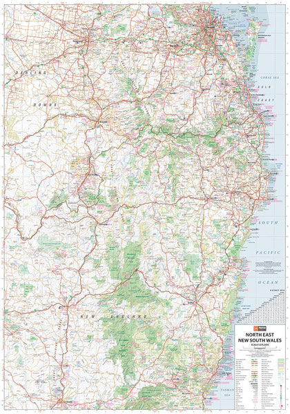
North East New South Wales Hema 700 x 1000mm Laminated Wall Map
$49.95
Afterpay is only available for orders between $50.00 and $1000.00 More info
Regional Mapping from Brisbane to Coffs Harbour with Campsites, National Parks & Points of Interest
Explore the lush hinterlands, sparkling coastlines, and scenic national parks of North East New South Wales with this detailed regional map by Hema—one of Australia’s most trusted cartographic publishers.
Covering the area from Brisbane in the north to Coffs Harbour in the south, this map is ideal for trip planning, camping, tourism, or educational use.
🗺️ Map Coverage
-
From Brisbane to Coffs Harbour
-
Inland to include the Great Dividing Range and hinterland communities
-
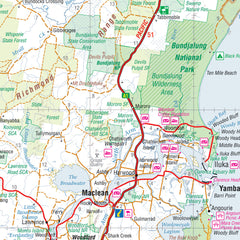
Detailed mapping of major highways, back roads, rivers, and regional towns
Features and Highlights
This map is packed with tourist-friendly detail, including:
-
🏕️ Camping Areas – Free and paid sites clearly marked
-
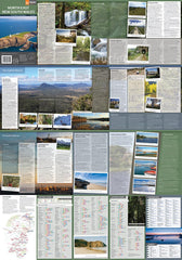
🌲 National Parks – All major parks labelled with facilities listed in a handy reference table
-
🏞️ Wilderness Areas – Bushwalking and nature-focused destinations highlighted
-
📍 Points of Interest – Lookouts, waterfalls, heritage sites, and visitor attractions
-
🧭 Tourist Information – Ideal for route planning and discovery
Bonus: Includes photographs and regional notes to inspire exploration of the region’s top destinations.
Durable Lamination
This version is fully laminated using 80-micron gloss film, making it:
-
✔️ Writeable & wipeable with whiteboard markers
-
✔️ Compatible with map dots for marking locations
-
✔️ Tear-resistant and water-repellent – perfect for road trips, offices, and classrooms
📌 Please note: This laminated map is created from a previously folded edition. Slight crease lines may be visible beneath the surface, but these do not affect usability or legibility.
📐 Specifications
| Specification | Detail |
|---|---|
| Publisher | Hema Maps |
| Map Type | Regional Wall Map (Laminated) |
| Scale | 1:375,000 |
| Dimensions | 700 mm (w) x 1000 mm (h) |
| Material | 120 gsm paper, encapsulated in 80-micron gloss laminate |
| Language | English |
🌟 Why Choose This Map?
-
✅ Designed by Australia’s most trusted mapmaker – Hema
-
✅ Ideal for caravaners, campers, and regional travellers
-
✅ Combines natural beauty with practical information
-
✅ Looks great on a wall and doubles as a trip planner
Pair this map with its companion title, Outback New South Wales, for full coverage of the state’s incredible diversity—from the coast to the red centre.
Plan your journey. Mark your adventure. Explore North East New South Wales like never before.


