- Australia ▾
- Topographic
▾
- Australia AUSTopo 250k (2025)
- Australia 50k Geoscience maps
- Australia 100k Geoscience maps
- Australia 250k Geoscience maps
- Australia 1:1m Geoscience maps
- New Zealand 50k maps
- New Zealand 250k maps
- New South Wales 25k maps
- New South Wales 50k maps
- New South Wales 100k maps
- Queensland 10k maps
- Queensland 25k maps
- Queensland 50k maps
- Queensland 100k maps
- Compasses
- Software
- GPS Systems
- Orienteering
- International ▾
- Wall Maps
▾
- World
- Australia & New Zealand
- Countries, Continents & Regions
- Historical
- Vintage National Geographic
- Australian Capital Territory
- New South Wales
- Northern Territory
- Queensland
- South Australia
- Tasmania
- Victoria
- Western Australia
- Celestial
- Children's
- Mining & Resources
- Wine Maps
- Healthcare
- Postcode Maps
- Electoral Maps
- Nautical ▾
- Flags
▾
- Australian Flag Sets & Banners
- Flag Bunting
- Handwavers
- Australian National Flags
- Aboriginal Flags
- Torres Strait Islander Flags
- International Flags
- Flagpoles & Accessories
- Australian Capital Territory Flags
- New South Wales Flags
- Northern Territory Flags
- Queensland Flags
- South Australia Flags
- Tasmania Flags
- Victoria Flags
- Western Australia Flags
- Gifts ▾
- Globes ▾
Dear valued customer. Please note that our checkout is not supported by old browsers. Please use a recent browser to access all checkout capabilities


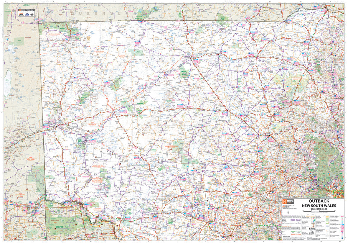
Outback New South Wales Hema Map 700 x 1000mm Laminated Wall Map
$49.95
Afterpay is only available for orders between $50.00 and $1000.00 More info
Explore the Heart of Inland Australia – From Tamworth to Beyond Broken Hill
Spanning vast landscapes and iconic tracks, this Outback NSW Regional Map by Hema is your ultimate guide to the remote and rugged interior of New South Wales. From Tamworth’s country charm to the arid red soils west of Broken Hill, this map captures the sheer scale, beauty, and adventure of Australia’s inland frontier.
🧭 Coverage
This map covers an enormous swathe of inland Australia, including:
-
Eastern Edge: Tamworth, Dubbo, and the Queensland border near St George and Cunnamulla
-
Western Extent: Beyond Broken Hill, extending just past Innamincka in the southern corner of the Northern Territory
-
Southern Reach: As far as Wagga Wagga and the tri-border junction of South Australia, Victoria, and New South Wales
Whether you're crossing the Darling River, following stock routes, or venturing deep into corner country, this map has you covered.
🗺️ Part of Hema’s NSW Regional Map Series, alongside North East NSW and South East NSW.
🌄 Features & Highlights
-
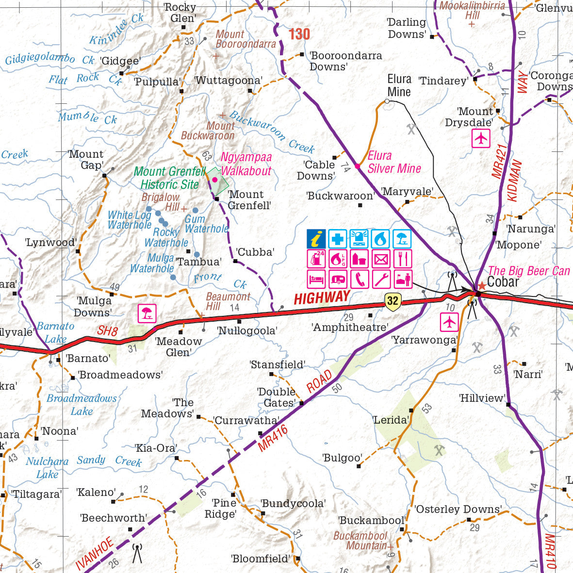
✅ Field-Checked Tracks – Verified by the renowned Hema Map Patrol for reliable navigation
-
🏕️ Camping & Rest Areas – Find your next campsite, from bush retreats to caravan parks
-
⛽ Fuel Stops – Including 24-hour service stations and LPG availability
-
🌿 National Parks & Reserves – Highlighting walking trails, access points, and park facilities
-
⭐ Points of Interest – Historic towns, natural wonders, scenic drives, and must-see attractions
-
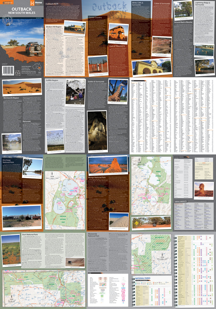
📚 Touring Information – The reverse side of the map is packed with expert travel tips, destinations, and road trip inspiration
🖊️ Laminated for Practical Use
Printed on high-quality stock and encapsulated in 80-micron gloss laminate, this version is designed for durability and interactivity:
-
Mark routes and notes with whiteboard markers
-
Use map dots to track your travels or plan your next adventure
-
Clean, wipe, and reuse with ease
🔎 Note: This laminated version has been produced from a folded map, so you may notice some minor fold lines, which do not affect the map's functionality.
📏 Specifications
| Feature | Details |
|---|---|
| Scale | 1:1,000,000 |
| Flat Size | 700 mm (W) x 1000 mm (H) |
| Map Type | Laminated (Flat from Folded) |
| Publisher | Hema Maps, Australia |
Perfect For:
-
4WD & Outback road trips
-
Route planning and pinning
-
Caravan and camper adventures
-
Educational or planning displays in schools or visitor centres
Plan your journey through the timeless landscapes of Outback NSW with this comprehensive and beautifully detailed Hema map—trusted by travellers, explorers, and adventurers alike.
Frequently Asked Questions
What are the dimensions of the Outback New South Wales Hema Map 700 x 1000mm Laminated Wall Map?
Mapworld wall maps range from standard 700×1000mm to large-format 1000×1430mm Supermaps. The exact dimensions for this map are shown in the product title. Where multiple sizes are available, select your preferred size when adding to cart.
Is this wall map available laminated?
Many Mapworld wall maps are available in paper, laminated, or framed finishes. Check the product options when adding to cart. Laminated maps are wipe-clean and more durable.
Is this the latest edition?
Mapworld stocks the most current editions available from all publishers. Edition year is shown in the product title where applicable. Mapworld updates its catalogue as new editions are released.
Can I write on or pin this wall map?
Laminated wall maps can be written on with whiteboard markers and wiped clean. Paper maps can be pinned on a corkboard. Choose a laminated option for a writeable surface.
Does Mapworld ship the Outback New South Wales Hema Map 700 x 1000mm Laminated Wall Map across Australia?
Yes, Mapworld ships Australia-wide. Standard shipping is a flat $7 rate, with free standard shipping on orders over $75. Express options are available at checkout. Most orders placed before 2pm AEST on weekdays are dispatched same day.
Related Items


© 2026 Mapworld. Website designed by Genie Media
X