- Australia ▾
- Topographic
▾
- Australia AUSTopo 250k (2025)
- Australia 50k Geoscience maps
- Australia 100k Geoscience maps
- Australia 250k Geoscience maps
- Australia 1:1m Geoscience maps
- New Zealand 50k maps
- New Zealand 250k maps
- New South Wales 25k maps
- New South Wales 50k maps
- New South Wales 100k maps
- Queensland 10k maps
- Queensland 25k maps
- Queensland 50k maps
- Queensland 100k maps
- Compasses
- Software
- GPS Systems
- Orienteering
- International ▾
- Wall Maps
▾
- World
- Australia & New Zealand
- Countries, Continents & Regions
- Historical
- Vintage National Geographic
- Australian Capital Territory
- New South Wales
- Northern Territory
- Queensland
- South Australia
- Tasmania
- Victoria
- Western Australia
- Celestial
- Children's
- Mining & Resources
- Wine Maps
- Healthcare
- Postcode Maps
- Electoral Maps
- Nautical ▾
- Flags
▾
- Australian Flag Sets & Banners
- Flag Bunting
- Handwavers
- Australian National Flags
- Aboriginal Flags
- Torres Strait Islander Flags
- International Flags
- Flagpoles & Accessories
- Australian Capital Territory Flags
- New South Wales Flags
- Northern Territory Flags
- Queensland Flags
- South Australia Flags
- Tasmania Flags
- Victoria Flags
- Western Australia Flags
- Gifts ▾
- Globes ▾
Dear valued customer. Please note that our checkout is not supported by old browsers. Please use a recent browser to access all checkout capabilities


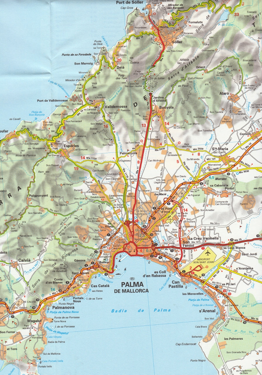


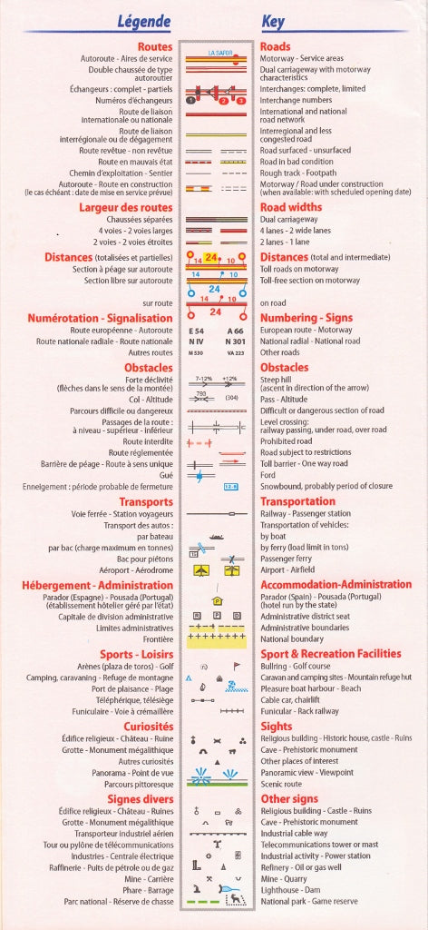
Balearic Islands - Regional Map Michelin 579
$21.95
Afterpay is only available for orders between $50.00 and $1000.00 More info
🏝️ Michelin Balearic Islands Regional Map 579
Mallorca • Menorca • Ibiza • Formentera
Scale 1:140,000 | Size: 1000 x 1100 mm | Folded Map
🧭 Your Essential Companion to Island Discovery
Unveil the beauty and diversity of Spain’s Balearic Islands with the trusted precision of Michelin Map 579. Covering Mallorca, Menorca, Ibiza, and Formentera, this highly detailed regional map offers everything you need to explore coastal roads, hidden coves, and charming hilltop towns — whether you're navigating by car, campervan, or bike.
Produced by Michelin — a name synonymous with cartographic excellence — this map blends elegant design with accurate road information, so your island getaway can be as adventurous or relaxed as you choose.
🗺️ Key Features
| ✅ Feature | 📍 Description |
|---|---|
| Comprehensive Road Network | Includes all major and secondary roads, scenic routes, and road numbers |
| Topographic Clarity | Michelin’s signature clear layout with shaded relief for mountains and coastline |
| Driving Distances & Times | Integrated distance and drive-time chart for easy trip planning |
| Indexed Place Names | Quickly locate towns, beaches, heritage sites, and inland villages |
| Map Coverage | Mallorca, Menorca, Ibiza, and Formentera at a detailed regional scale |
| Scale | 1:140,000 — ideal for both long-distance navigation and local route exploration |
🌄 What You'll Discover with This Map
-
Mallorca – Discover the Tramuntana mountains, the historic capital Palma, and dramatic coastal drives
-
Menorca – Explore quiet beaches, prehistoric ruins, and lush countryside trails
-
Ibiza – Beyond nightlife, find tranquil coves, pine-covered hills, and whitewashed towns
-
Formentera – Bask in the turquoise waters and laid-back vibes of the Balearics’ hidden gem
Michelin Map 579 showcases not only the roadways but also natural landmarks, tourist attractions, and regional context, making it perfect for on-the-ground adventure or planning from afar.
📐 Product Specifications
| Attribute | Details |
|---|---|
| Title | Michelin Balearic Islands Regional Map 579 |
| Publisher | Michelin Maps, France |
| Edition | Latest available |
| Map Type | Folded regional road map |
| Scale | 1:140,000 |
| Flat Size | 1000 mm (W) x 1100 mm (H) |
| Folded Size | Approx. 250 mm x 130 mm |
| Material | Paper, suitable for framing or folding |
| Place Name Index | Yes |
| Drive-Time Chart | Yes |
| Language | Local place names with multilingual key |
🚗 Perfect For
-
🌴 Island Road Trippers – Plan your route across coastal drives and into remote interior regions
-
🏕 Vanlifers & Campers – Navigate camping spots, fuel stops, and out-of-the-way beaches
-
🚲 Cyclists – Use the map to track scenic routes and avoid busy roads
-
🏡 Boutique Travel Planners – Offer guests curated island itineraries with a visual aid
-
📚 Map Collectors & Decorators – A beautiful reference piece for lovers of Spain and Mediterranean culture
🌍 Why Choose Michelin Maps?
Michelin has guided travellers for over 100 years with:
-
✔️ Award-winning cartographic clarity
-
✔️ Up-to-date travel data and scenic routes
-
✔️ Integration with Michelin Green Guide destinations
-
✔️ Trusted accuracy and print quality
🎁 A Thoughtful Gift for Explorers
Pair this map with a Spanish phrasebook, Michelin Green Guide for Spain, or a travel journal to create the perfect gift for anyone planning a Mediterranean escape or reminiscing about their time on the islands.
✨ Let the Journey Begin
From sun-soaked coastal roads to hidden villages tucked into forested hills, the Balearic Islands offer a rich palette of experiences. With Michelin Map 579, you’ll have the confidence to explore it all — detours, discoveries, and all.
🛒 Add to cart today and start planning your perfect island adventure with Michelin by your side.
Frequently Asked Questions
Where can I buy the Balearic Islands - Regional Map Michelin 579?
The Balearic Islands - Regional Map Michelin 579 is available to buy online from Mapworld, Australia's largest map and geographic product retailer, with fast shipping Australia-wide.
Is the Balearic Islands - Regional Map Michelin 579 in stock at Mapworld?
Mapworld maintains extensive stock across its map range and aims for fast dispatch. Orders placed before 2pm AEST on business days are typically dispatched the same day, with standard and express Australia-wide delivery options available.
What is Mapworld's returns policy?
Mapworld accepts returns on undamaged items in original condition. Contact Mapworld within 90 days of purchase to arrange a return or exchange.
Does Mapworld ship the Balearic Islands - Regional Map Michelin 579 across Australia?
Yes, Mapworld ships Australia-wide. Standard shipping is a flat $7 rate, with free standard shipping on orders over $75. Express options are available at checkout. Most orders placed before 2pm AEST on weekdays are dispatched same day.
Related Items


© 2026 Mapworld. Website designed by Genie Media
X