- Australia ▾
- Topographic
▾
- Australia AUSTopo 250k (2025)
- Australia 50k Geoscience maps
- Australia 100k Geoscience maps
- Australia 250k Geoscience maps
- Australia 1:1m Geoscience maps
- New Zealand 50k maps
- New Zealand 250k maps
- New South Wales 25k maps
- New South Wales 50k maps
- New South Wales 100k maps
- Queensland 10k maps
- Queensland 25k maps
- Queensland 50k maps
- Queensland 100k maps
- Compasses
- Software
- GPS Systems
- Orienteering
- International ▾
- Wall Maps
▾
- World
- Australia & New Zealand
- Countries, Continents & Regions
- Historical
- Vintage National Geographic
- Australian Capital Territory
- New South Wales
- Northern Territory
- Queensland
- South Australia
- Tasmania
- Victoria
- Western Australia
- Celestial
- Children's
- Mining & Resources
- Wine Maps
- Healthcare
- Postcode Maps
- Electoral Maps
- Nautical ▾
- Flags
▾
- Australian Flag Sets & Banners
- Flag Bunting
- Handwavers
- Australian National Flags
- Aboriginal Flags
- Torres Strait Islander Flags
- International Flags
- Flagpoles & Accessories
- Australian Capital Territory Flags
- New South Wales Flags
- Northern Territory Flags
- Queensland Flags
- South Australia Flags
- Tasmania Flags
- Victoria Flags
- Western Australia Flags
- Gifts ▾
- Globes ▾
Dear valued customer. Please note that our checkout is not supported by old browsers. Please use a recent browser to access all checkout capabilities


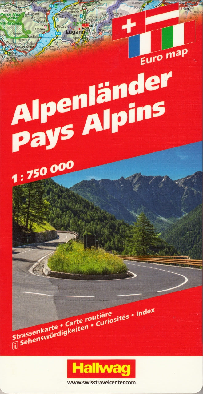
Alpine Countries - The Alps Hallwag Map
$25.95
Afterpay is only available for orders between $50.00 and $1000.00 More info
The Ultimate Overland Map for Exploring Europe's Mountain Heartland
There’s no region quite like the Alps. From the snow-dusted peaks of Austria to the vineyard-lined valleys of northern Italy, from Switzerland’s engineering marvels to Bavaria’s winding country roads, the Alpine arc is one of the most scenic, culturally rich, and adventure-packed regions on Earth.
The Hallwag Alpine Countries Road & Rail Map brings this vast and varied landscape to life with remarkable clarity, intuitive design, and detailed multi-modal transport coverage. Whether you're planning a self-drive itinerary, crossing countries by train, or plotting the ultimate overland escape, this map is the companion you want on your table, in your van, or hanging on your wall.
🔍 Explore Five Countries in One Master Map
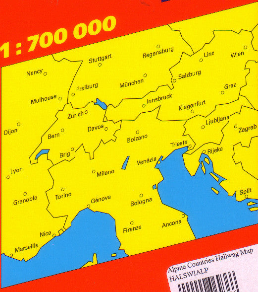
This large-format map (1000 mm x 1250 mm) covers France, Germany, Switzerland, Italy, and Austria—offering a panoramic view of the interconnected Alpine corridor. It reveals not only the roads and railway lines that connect these countries but the natural beauty and tourist highlights that make them unforgettable.
From Mont Blanc to the Dolomites, from Lake Geneva to Salzburg, this map doesn’t just show you where to go—it helps you understand how to get there, what’s nearby, and why it’s worth the journey.
🧭 Key Features and Travel Insights
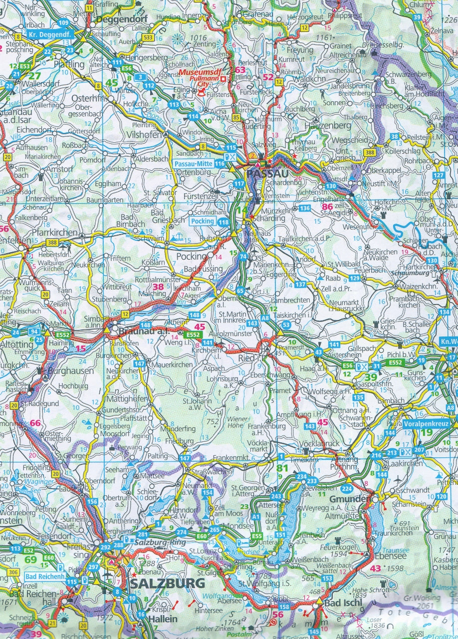
🚗 Roads and Highways
-
Includes all major and minor road networks, clearly marked with road numbers and types
-
Ideal for route planning, scenic drives, and cross-border navigation
-
Features alpine passes, tunnel routes, and car ferry connections
-
Great for campervan trips, motorbike tours, or scenic car holidays
🚄 Rail Networks
-
Covers regional, national and international railway lines across all five countries
-
Perfect for Interrail and Eurail travellers, with visible connections between cities and small alpine towns
-
Great for visualising mountain railway routes such as the Glacier Express, Bernina Express, and ÖBB Railjet lines
🏞️ Tourist & Cultural Landmarks
-
A wide range of symbols mark:
-
Natural landmarks (mountain peaks, waterfalls, lakes)
-
Cultural and historical sites
-
Scenic viewpoints and driving routes
-
Seasonal campsites for outdoor stays in spring, summer, and autumn
-
🧳 International & Multilingual Functionality
-
A multi-language index (German, English, French, Italian) ensures accessibility for all users
-
Place names are shown in local spelling with easy cross-referencing
-
Great for multilingual families, educators, and international travellers
📐 Map Specifications
| Feature | Detail |
|---|---|
| Coverage | France, Germany, Switzerland, Italy, Austria |
| Scale | 1:700,000 (1 cm = 7 km) |
| Size | 1000 mm wide × 1250 mm high |
| Format | Folded or rolled (select at checkout) |
| Publisher | Hallwag International |
| Language Index | English, German, French, Italian |
This map is printed on high-quality stock to ensure long-term durability, whether used on the road or framed as a reference piece at home or in a professional setting.
🎯 Who Will Benefit Most from This Map?
✨ Travellers & Tourers
Whether you're in a rental car, classic campervan, or sporty convertible, this map helps you navigate and discover roads less travelled. For those travelling with Eurail or Interrail passes, it provides a bird’s-eye view of your rail options and scenic detours.
🏕️ Vanlifers, RV Adventurers & Cyclists
It’s the perfect blend of practical infrastructure and natural detail—ideal for planning stays near nature, finding seasonal campsites, or choosing quieter, more scenic routes through the mountains.
🎓 Teachers, Geography Buffs & Map Collectors
Clear, uncluttered cartography with rich geographic and cultural information makes this an excellent teaching tool or collector’s piece. Hang it on a wall and turn any room into a launchpad for conversation and learning.
🏡 Homeowners & Decorators
Attractive enough to serve as wall art, especially when mounted or framed. The regional colours, typography, and geographic balance lend it a classic European charm suitable for home studies, libraries, and travel-themed spaces.
💬 What Customers Are Saying
“We used this map to plan our self-drive trip from Geneva through Austria and down into Italy. Every town, road, and train was exactly where we expected—superb detail.”
— ⭐⭐⭐⭐⭐ Laura & Ben, UK
“I’m planning an Interrail trip with my teenagers, and this map has been a great way to visualise everything without switching between five digital maps.”
— ⭐⭐⭐⭐⭐ Michael, Germany
“We framed it in the office—beautiful and useful. Clients love tracing their journeys and planning new ones.”
— ⭐⭐⭐⭐⭐ Pia, Travel Advisor, Austria
🌍 A Map That Connects Journeys Across Borders
The Hallwag Alpine Countries Map doesn’t just take you from point A to point B—it connects cultures, landscapes, and generations of travellers. It helps you see the Alps not as a barrier, but as the vibrant bridge between countries, histories, and experiences.
Use it to:
-
Plan a summer of driving through wine country and glacial valleys
-
Navigate train routes between medieval cities and modern metropolises
-
Find hidden villages, picnic spots, and scenic viewpoints
-
Inspire your next travel chapter—or remember the last one
🛒 Add to Cart and Start Mapping Your Alpine Adventure
Whether you’re en route, in planning mode, or simply dreaming from home, this map will serve you well for years to come.


