- Australia ▾
- Topographic
▾
- Australia AUSTopo 250k (2024)
- Australia 50k Geoscience maps
- Australia 100k Geoscience maps
- Australia 250k Geoscience maps
- Australia 1.1m Geoscience maps
- New Zealand 50k maps
- New Zealand 250k maps
- New South Wales 25k maps
- New South Wales 50k maps
- New South Wales 100k maps
- Queensland 10k maps
- Queensland 25k maps
- Queensland 50k maps
- Queensland 100k maps
- Compasses
- Software
- GPS Systems
- Orienteering
- International ▾
- Wall Maps
▾
- World
- Australia & New Zealand
- Countries, Continents & Regions
- Historical
- Vintage National Geographic
- Australian Capital Territory
- New South Wales
- Northern Territory
- Queensland
- South Australia
- Tasmania
- Victoria
- Western Australia
- Celestial
- Children's
- Mining & Resources
- Wine Maps
- Healthcare
- Postcode Maps
- Electoral Maps
- Nautical ▾
- Flags
▾
- Australian Flag Sets & Banners
- Flag Bunting
- Handwavers
- Australian National Flags
- Aboriginal Flags
- Torres Strait Islander Flags
- International Flags
- Flagpoles & Accessories
- Australian Capital Territory Flags
- New South Wales Flags
- Northern Territory Flags
- Queensland Flags
- South Australia Flags
- Tasmania Flags
- Victoria Flags
- Western Australia Flags
- Gifts ▾
- Globes ▾
Dear valued customer. Please note that our checkout is not supported by old browsers. Please use a recent browser to access all checkout capabilities
Arctic Ocean Political Atlas of the World, 11th Edition, National Geographic Wall Map
$69.95
or make 4 interest-free payments of
$17.49 AUD
fortnightly with
![]() More info
More info
National Geographic – Atlas of the World, 11th Edition
A striking cartographic portrait of Earth’s northernmost frontier
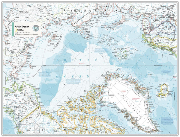
Embark on a captivating journey to the top of the world with this beautifully detailed Political Map of the Arctic Ocean, as featured in the 11th Edition of National Geographic’s World Atlas. With its crisp detailing, elegant design, and masterful cartography, this map invites you to explore the complex geography and geopolitics of one of Earth's most intriguing and remote regions.
Rendered with National Geographic’s signature precision and care, the Arctic Ocean is revealed in all its stark, icy grandeur — bordered by the vast northern coastlines of Canada, Russia, Greenland, Norway, and the United States (Alaska). It’s a map that not only informs but inspires curiosity about climate, territory, and exploration.
❄️ Features That Bring the North to Life
-
🗺️ Crisp international boundaries and territorial claims
-
🌊 Oceanic depth contours and shaded relief showing the seafloor
-
🏔️ Surrounding landmasses with cities, rivers, islands, and political divisions
-
🧊 Polar projection specially designed for Arctic navigation
-
🏫 Ideal for classrooms, environmental studies, or polar research spaces
The map uses a clean, easy-to-read colour palette with icy blues, subtle land shading, and carefully placed typography to maintain legibility — even with dense geographic data. This is the perfect educational and decorative piece for those passionate about global geography and environmental awareness.
📐 Available Formats – Made to Last, Made to Impress
Choose the format that best suits your space or purpose:
| Format | Description |
|---|---|
| 📄 Paper (160 gsm) | Elegant matte finish, ideal for framing under glass |
| 💧 Laminated (Gloss) | Durable, wipe-clean surface with 80-micron encapsulated gloss lamination |
| 🖼️ Canvas (395 gsm) | Archival-grade HP Matte Canvas with pigment inks – fade-resistant and tactile |
| 🪵 Laminated + Hang Rails | Laminated map with top & bottom natural timber rails and cord for easy hanging |
| 🪵 Canvas + Hang Rails | Canvas with timber hang rails – a sophisticated finish ready to hang |
🕰️ Please allow up to 10 working days for delivery of hang-railed maps – each one is custom-mounted by our artisan framer.
📊 Specifications
| Detail | Specification |
|---|---|
| Title | Arctic Ocean – Political Wall Map |
| Edition | Atlas of the World, 11th Edition |
| Publisher | National Geographic |
| Map Style | Political with shaded relief |
| Projection | Polar Azimuthal (North Pole-centred) |
| Scale | Variable due to polar projection |
| Standard Size | 790 mm (wide) × 610 mm (high) |
| Supermap Size | 915 mm (wide) × 1197 mm (high) |
| Language | English |
| Published | 2019 |
| Made in | Australia |
🌟 Why This Map Belongs on Your Wall
✅ Unparalleled cartographic authority from National Geographic
✅ Stunning polar design makes complex geography beautifully legible
✅ Decorative and educational – perfect for scholars, scientists, and students
✅ Premium materials for lasting clarity, colour, and impact
✅ Crafted in Australia with local expertise and care
Hang this map as a statement — not just of style, but of curiosity and respect for one of the planet’s most important and fragile regions. From melting ice caps to emerging maritime routes, the Arctic Ocean is a vital frontier of the 21st century. This map will keep it top of mind, and beautifully in view.


