- Australia ▾
- Topographic
▾
- Australia AUSTopo 250k (2025)
- Australia 50k Geoscience maps
- Australia 100k Geoscience maps
- Australia 250k Geoscience maps
- Australia 1:1m Geoscience maps
- New Zealand 50k maps
- New Zealand 250k maps
- New South Wales 25k maps
- New South Wales 50k maps
- New South Wales 100k maps
- Queensland 10k maps
- Queensland 25k maps
- Queensland 50k maps
- Queensland 100k maps
- Compasses
- Software
- GPS Systems
- Orienteering
- International ▾
- Wall Maps
▾
- World
- Australia & New Zealand
- Countries, Continents & Regions
- Historical
- Vintage National Geographic
- Australian Capital Territory
- New South Wales
- Northern Territory
- Queensland
- South Australia
- Tasmania
- Victoria
- Western Australia
- Celestial
- Children's
- Mining & Resources
- Wine Maps
- Healthcare
- Postcode Maps
- Electoral Maps
- Nautical ▾
- Flags
▾
- Australian Flag Sets & Banners
- Flag Bunting
- Handwavers
- Australian National Flags
- Aboriginal Flags
- Torres Strait Islander Flags
- International Flags
- Flagpoles & Accessories
- Australian Capital Territory Flags
- New South Wales Flags
- Northern Territory Flags
- Queensland Flags
- South Australia Flags
- Tasmania Flags
- Victoria Flags
- Western Australia Flags
- Gifts ▾
- Globes ▾
Dear valued customer. Please note that our checkout is not supported by old browsers. Please use a recent browser to access all checkout capabilities


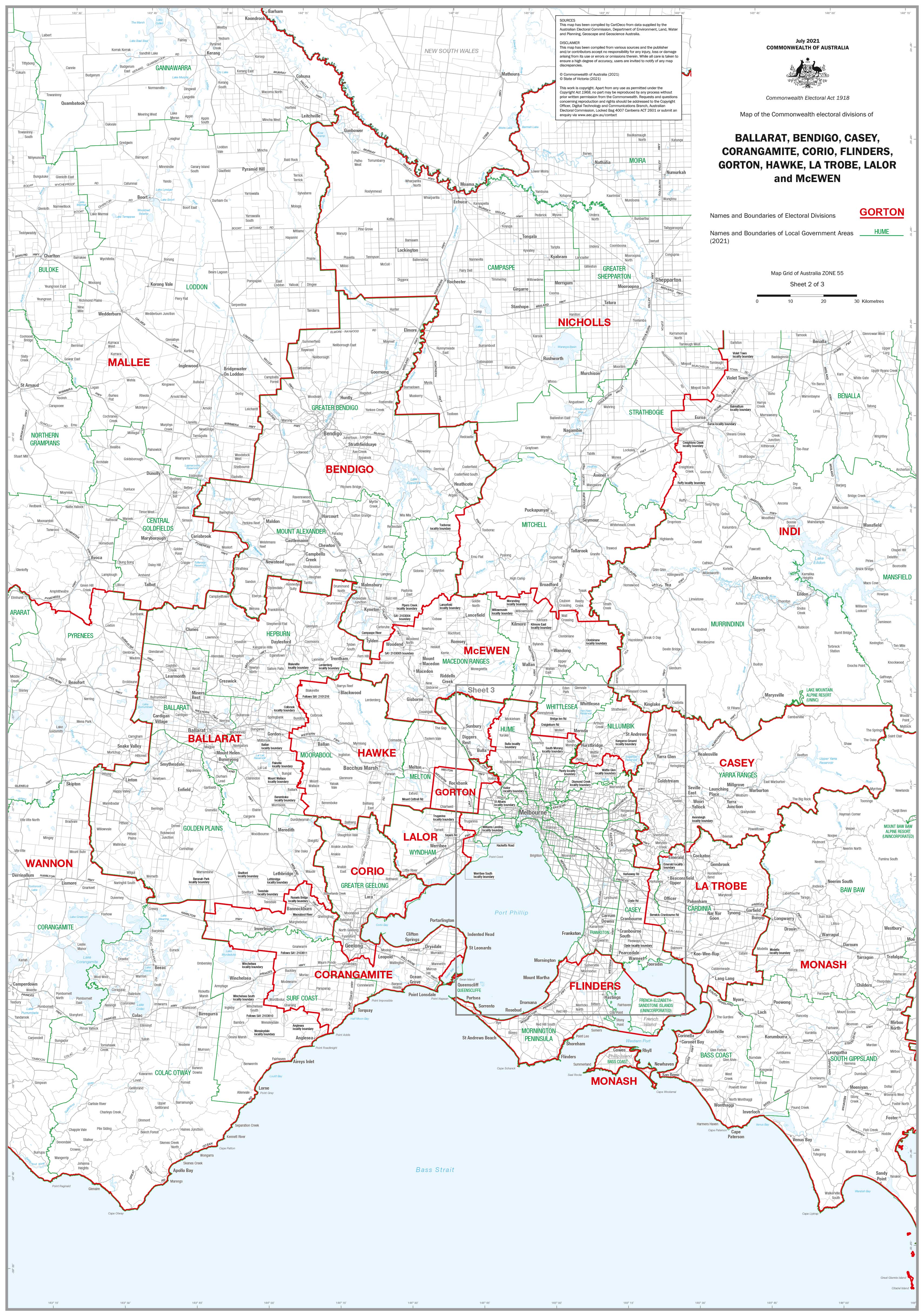
Victoria Federal Electoral Divisions and Local Government Areas Map - Ballarat & Area
$59.95
or make 4 interest-free payments of
$14.99 AUD
fortnightly with
![]() More info
More info
Victoria — Federal Electoral Divisions & LGAs (Ballarat & Region)
1000 × 700 mm • Paper / Laminated / Laminated + Hang Rails / Canvas / Canvas + Hang Rails • Made in Australia
A clear, professional snapshot of central & western Victoria’s civic landscape around Ballarat—combining Federal Electoral Divisions with Local Government Areas (LGAs). Built for electoral offices, councils, planners, educators, and community organisations that need fast, reliable boundary awareness on the wall.
🔍 Coverage at a Glance
-
🗳️ Federal electorates (labelled & boundary-lined):
Ballarat, Bendigo, Casey, Corangamite, Corio, Flinders, Gorton, Hawke, La Trobe, Lalor, McEwen -
🏛️ Local Government Areas (LGAs): Council names and borders displayed alongside federal divisions for easy cross-reference
-
👁️ Wall-readable cartography: Calm palette, tuned line weights, crisp typography, and a clean legend for quick interpretation
See how federal seats intersect with LGAs—clearly, accurately, and at a glance.
Why This Map Works
-
Instant orientation: Identify the right electorate and LGA without switching tools
-
Planning-ready: Support community engagement, policy research, logistics, and reporting
-
High-resolution output: Crisp lines and legible labels at wall distance and up close
🎨 Finishes & Display Options
-
📄 Paper (160 gsm Matte)
-
Premium matte stock for low glare and crisp detail—ideal for framing under glass in offices, chambers, and classrooms.
-
-
💧 Laminated (True Encapsulation)
-
Printed on 120 gsm, sealed in 2 × 80-micron gloss laminate (edge-sealed).
-
Wipe-clean • Tear-resistant • Water-resistant — use whiteboard markers and map dots for temporary notes.
-
-
🪵 Laminated + Timber Hang Rails (Ready to Hang)
-
Natural lacquered timber rails (top & bottom) with a top hanging cord.
-
Professional presentation—hang from a single hook.
-
⏱️ Custom finish—please allow up to 10 working days for rail fitting.
-
-
🖼️ Canvas (HP 395 gsm Professional Matte)
-
Gallery-grade, low-glare canvas printed with archival pigment inks for excellent fade resistance and a refined look.
-
-
🪵 Canvas + Timber Hang Rails
-
Same premium canvas with lacquered timber rails (top & bottom) + top hanging cord—gallery-style, ready to hang.
-
⏱️ Custom finish—please allow up to 10 working days for rail fitting.
-
📐 Specifications
| Feature | Details |
|---|---|
| Title | Victoria — Federal Electoral Divisions & LGAs (Ballarat & Region) |
| Size | 1000 mm (W) × 700 mm (H) |
| Content | Federal division names & boundaries + LGA names & boundaries |
| Formats | Paper • Laminated • Laminated + Hang Rails • Canvas • Canvas + Hang Rails |
| Printing | High-resolution output with archival pigment inks for clarity & longevity |
| Origin | Made in Australia |
🛠️ Customisation
Need to zoom in on one electorate? We produce division-specific maps on request, with optional overlays such as street grids, polling places, community facilities, drive-time rings, and branding. Alternate sizes and bulk solutions available.
🎯 Perfect For
-
Electoral offices & campaign teams
-
Local government & planning units
-
Community organisations & advocacy groups
-
Schools, universities & libraries
-
Consultants, researchers & regional stakeholders
🤝 Our Commitment
-
Local craftsmanship: Designed, printed, and finished in Australia for consistent quality and fast support.
-
Archival quality: Premium papers/canvas and pigment-based inks for long-lasting fidelity.
-
Clarity first: Legends, symbols, and typographic hierarchies tuned for wall readability.
-
Built to last: True-encapsulation lamination and 395 gsm canvas stand up to daily use.
-
Packed with care: Hand-checked and securely shipped—arrives clean and display-ready.
-
Flexible options: We’ll tailor overlays, branding, and sizing to your workflow.
🛒 Put central & western Victoria’s political and administrative mapwork on the wall—durable, legible, and ready for daily decision-making.
Frequently Asked Questions
Where can I buy the Victoria Federal Electoral Divisions and Local Government Areas Map - ?
The Victoria Federal Electoral Divisions and Local Government Areas Map - is available to buy online from Mapworld, Australia's largest map and geographic product retailer, with fast shipping Australia-wide.
Is the Victoria Federal Electoral Divisions and Local Government Areas Map - in stock at Mapworld?
Mapworld maintains extensive stock across its map range and aims for fast dispatch. Orders placed before 2pm AEST on business days are typically dispatched the same day, with standard and express Australia-wide delivery options available.
What is Mapworld's returns policy?
Mapworld accepts returns on undamaged items in original condition. Contact Mapworld within 90 days of purchase to arrange a return or exchange.
Does Mapworld ship the Victoria Federal Electoral Divisions and Local Government Areas Map - across Australia?
Yes, Mapworld ships Australia-wide. Standard shipping is a flat $7 rate, with free standard shipping on orders over $75. Express options are available at checkout. Most orders placed before 2pm AEST on weekdays are dispatched same day.
Related Items

© 2026 Mapworld. Website designed by Genie Media
X