- Australia ▾
- Topographic
▾
- Australia AUSTopo 250k (2025)
- Australia 50k Geoscience maps
- Australia 100k Geoscience maps
- Australia 250k Geoscience maps
- Australia 1:1m Geoscience maps
- New Zealand 50k maps
- New Zealand 250k maps
- New South Wales 25k maps
- New South Wales 50k maps
- New South Wales 100k maps
- Queensland 10k maps
- Queensland 25k maps
- Queensland 50k maps
- Queensland 100k maps
- Compasses
- Software
- GPS Systems
- Orienteering
- International ▾
- Wall Maps
▾
- World
- Australia & New Zealand
- Countries, Continents & Regions
- Historical
- Vintage National Geographic
- Australian Capital Territory
- New South Wales
- Northern Territory
- Queensland
- South Australia
- Tasmania
- Victoria
- Western Australia
- Celestial
- Children's
- Mining & Resources
- Wine Maps
- Healthcare
- Postcode Maps
- Electoral Maps
- Nautical ▾
- Flags
▾
- Australian Flag Sets & Banners
- Flag Bunting
- Handwavers
- Australian National Flags
- Aboriginal Flags
- Torres Strait Islander Flags
- International Flags
- Flagpoles & Accessories
- Australian Capital Territory Flags
- New South Wales Flags
- Northern Territory Flags
- Queensland Flags
- South Australia Flags
- Tasmania Flags
- Victoria Flags
- Western Australia Flags
- Gifts ▾
- Globes ▾
Dear valued customer. Please note that our checkout is not supported by old browsers. Please use a recent browser to access all checkout capabilities


Tasmania Federal Electoral Divisions and Local Government Areas Map
$59.95
or make 4 interest-free payments of
$14.99 AUD
fortnightly with
![]() More info
More info
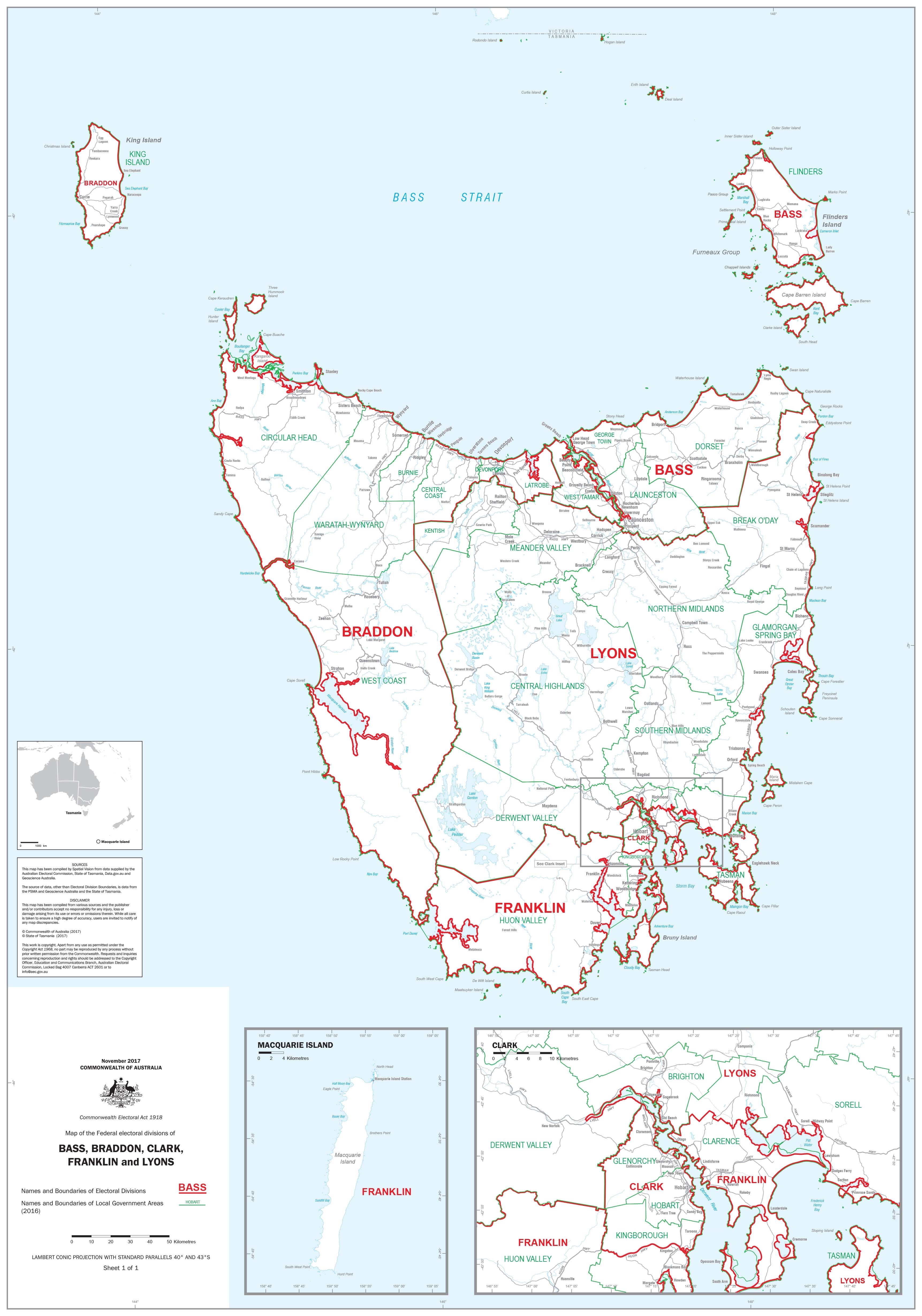
Tasmania — Federal Electoral Divisions & LGAs
Statewide Wall Map • 1000 × 700 mm • Paper / Laminated / Laminated + Hang Rails / Canvas / Canvas + Hang Rails
A clear, authoritative overview of Tasmania’s federal electoral divisions and Local Government Areas (LGAs)—engineered for planners, researchers, educators, government teams, businesses, and community organisations. Wall-readable at a glance, elegant up close.
🔍 At a Glance (What’s on the Map)
-
🗺️ Federal divisions: Bass, Braddon, Clark, Franklin, Lyons—precisely delineated and labelled
-
🏛️ LGAs: Council names & boundaries across the entire state
-
👁️ Wall clarity: Calm palette, tuned line weights, and crisp typography for distance viewing
-
🧭 Context you can use: Major towns and wayfinding features for quick orientation
-
📏 Legend & scale: Simple, intuitive symbology for instant interpretation
Clean symbology and a tuned legend make complex boundaries instantly legible—even from across the room.
Why This Map Works
-
Accurate & current: Produced with the latest available boundary data
-
Planning-ready: Perfect for outreach, service planning, logistics, and stakeholder briefings
-
Education-friendly: A dependable visual aid for civics and geography
-
Professional finish: Suits boardrooms, classrooms, libraries, and public spaces
🎨 Finishes & Display Options
-
📄 Paper (Heavyweight 160 gsm, FSC matte-coated)
-
Smooth, sturdy stock—ideal for framing under glass with low glare and crisp detail.
-
-
💧 Laminated (True Encapsulation)
-
Printed on 120 gsm stock then sealed in 2 × 80-micron gloss laminate (edge-to-edge).
-
Waterproof • Tear-resistant • Wipe-clean — whiteboard-marker & map-dot friendly.
-
-
🪵 Laminated + Timber Hang Rails (Ready to Hang)
-
Laminated map finished with natural lacquered timber rails (top & bottom) and a top hanging cord.
-
Neat, professional presentation—hang from a single hook.
-
⏱️ Custom finish: please allow up to 10 working days for rail fitting.
-
-
🖼️ Canvas (HP 395 gsm Professional Matte)
-
Printed with HP archival pigment inks for sharp, fade-resistant colour.
-
Gallery-grade, non-glare presentation for executive and public spaces.
-
-
🪵 Canvas + Timber Hang Rails
-
Same canvas, finished with lacquered timber rails (top & bottom) + top hanging cord—gallery-style, ready to hang.
-
⏱️ Custom finish: please allow up to 10 working days for rail fitting.
-
🌟 Perfect For
-
Government & policy teams: Planning, resource allocation, and demographic analysis
-
Campaigns & consultants: Boundary awareness, voter distribution, and outreach
-
Business & logistics: Council-based territory planning and route optimisation
-
Education & research: Teaching Tasmanian civics, governance, and geography
-
Community & advocacy groups: Grant planning, workshops, and public engagement
📐 Size
-
Standard: 1000 mm (W) × 700 mm (H) • Portrait
📊 Specifications
| Attribute | Details |
|---|---|
| Title | Tasmania — Federal Electoral Divisions & LGAs |
| Coverage | Federal divisions Bass, Braddon, Clark, Franklin, Lyons + all Tasmanian LGAs |
| Content | Official division names & boundaries; LGA names & boundaries |
| Formats | Paper • Laminated • Laminated + Timber Hang Rails • Canvas • Canvas + Timber Hang Rails |
| Paper (Unlaminated) | 160 gsm FSC matte-coated |
| Laminate | 120 gsm print encapsulated in 2 × 80-micron gloss |
| Canvas | HP 395 gsm Professional Matte |
| Inks | HP archival pigment-based (fade-resistant) |
| Size | 1000 × 700 mm |
| Delivery | Made to order—please allow 5–7 working days (hang-railed options up to 10 working days) |
| Made in | Australia |
🤝 Our Commitment
-
Local craftsmanship: Printed and finished in Australia with careful colour management
-
Archival quality: Pigment-based inks and premium stocks for long-lasting fidelity
-
Built to last: True encapsulation and 395 gsm canvas for daily display use
-
Clarity first: Legends, symbols, and labels tuned for wall readability
-
Flexible options: Custom sizes, branding, and division-specific close-ups available on request
🛒 Choose your finish to bring Tasmania’s electoral and LGA boundaries into sharp focus—on the wall, at a glance.
Frequently Asked Questions
Where can I buy the Tasmania Federal Electoral Divisions and Local Government Areas Map?
The Tasmania Federal Electoral Divisions and Local Government Areas Map is available to buy online from Mapworld, Australia's largest map and geographic product retailer, with fast shipping Australia-wide.
Is the Tasmania Federal Electoral Divisions and Local Government Areas Map in stock at Mapworld?
Mapworld maintains extensive stock across its map range and aims for fast dispatch. Orders placed before 2pm AEST on business days are typically dispatched the same day, with standard and express Australia-wide delivery options available.
What is Mapworld's returns policy?
Mapworld accepts returns on undamaged items in original condition. Contact Mapworld within 90 days of purchase to arrange a return or exchange.
Does Mapworld ship the Tasmania Federal Electoral Divisions and Local Government Areas Map across Australia?
Yes, Mapworld ships Australia-wide. Standard shipping is a flat $7 rate, with free standard shipping on orders over $75. Express options are available at checkout. Most orders placed before 2pm AEST on weekdays are dispatched same day.
Related Items

© 2026 Mapworld. Website designed by Genie Media
X