- Australia ▾
- Topographic
▾
- Australia AUSTopo 250k (2025)
- Australia 50k Geoscience maps
- Australia 100k Geoscience maps
- Australia 250k Geoscience maps
- Australia 1:1m Geoscience maps
- New Zealand 50k maps
- New Zealand 250k maps
- New South Wales 25k maps
- New South Wales 50k maps
- New South Wales 100k maps
- Queensland 10k maps
- Queensland 25k maps
- Queensland 50k maps
- Queensland 100k maps
- Compasses
- Software
- GPS Systems
- Orienteering
- International ▾
- Wall Maps
▾
- World
- Australia & New Zealand
- Countries, Continents & Regions
- Historical
- Vintage National Geographic
- Australian Capital Territory
- New South Wales
- Northern Territory
- Queensland
- South Australia
- Tasmania
- Victoria
- Western Australia
- Celestial
- Children's
- Mining & Resources
- Wine Maps
- Healthcare
- Postcode Maps
- Electoral Maps
- Nautical ▾
- Flags
▾
- Australian Flag Sets & Banners
- Flag Bunting
- Handwavers
- Australian National Flags
- Aboriginal Flags
- Torres Strait Islander Flags
- International Flags
- Flagpoles & Accessories
- Australian Capital Territory Flags
- New South Wales Flags
- Northern Territory Flags
- Queensland Flags
- South Australia Flags
- Tasmania Flags
- Victoria Flags
- Western Australia Flags
- Gifts ▾
- Globes ▾
Dear valued customer. Please note that our checkout is not supported by old browsers. Please use a recent browser to access all checkout capabilities


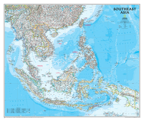
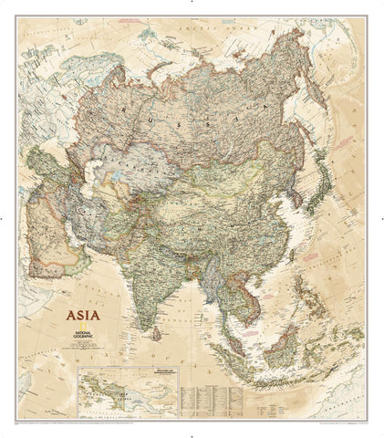
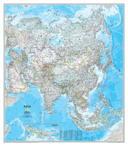
Asia Political Atlas of the World, 11th Edition, National Geographic Wall Map
$69.95
or make 4 interest-free payments of
$17.49 AUD
fortnightly with
![]() More info
More info
National Geographic | Atlas of the World, 11th Edition
Available in Paper, Laminated, and Canvas Formats (Optional Hang Rails)
Explore Asia’s nations, boundaries, and beauty—at a glance and in vivid detail.
Step into the vibrant and ever-evolving tapestry of the world’s largest continent with this Asia Political Wall Map by National Geographic, adapted from the 11th Edition Atlas of the World. Designed with precision, this map balances modern cartographic science with a classic aesthetic that brings Asia’s geopolitical complexity to life.
Whether you're exploring major population centres, examining shifting borders, or tracing the journeys of rivers and trade routes, this wall map is a compelling visual guide to the region’s rich and dynamic political landscape.
🌏 What Makes This Map Exceptional
| Feature | Description |
|---|---|
| 🧭 Political Clarity | Boldly defined international borders and clearly labelled countries and capitals |
| 🏙️ Urban Detail | Cities, towns, and major transportation hubs are accurately marked |
| 🏞️ Natural Features | Rivers, lakes, and mountain ranges provide essential geographic context |
| 🌐 Projection | Two-Point Equidistant Projection for proportionally correct distance from two key points |
| 🎨 Palette & Relief | Soft blue oceans, subtle shaded relief, and warm earth tones used for over 75 years by National Geographic |
Every feature is thoughtfully placed for clarity and legibility—making this map both informative and visually stunning.
🖼️ Format Options to Suit Every Setting
| Format | Finish & Features |
|---|---|
| 📄 Paper | Printed on premium 170gsm matte paper – ideal for framing under glass |
| 💧 Laminated | Encapsulated in 80-micron gloss laminate (both sides) – durable and marker-friendly |
| 🪵 Laminated + Hang Rails | Laminated version with elegant timber rails and top hanging cord – ready to display |
| 🖼️ Canvas | Printed on 395gsm matte artist’s canvas using fade-resistant pigment inks |
| 🪵 Canvas + Hang Rails | Canvas map with handcrafted timber rails – a gallery-quality presentation |
🛠️ Please allow up to 10 working days for delivery of hang-railed maps, as these are custom-finished by our framer.
📐 Map Specifications
| Attribute | Details |
|---|---|
| Title | Asia Political Wall Map |
| Publisher | National Geographic |
| Source | Atlas of the World, 11th Edition |
| Projection | Two-Point Equidistant |
| Map Type | Political with Physical Context |
| Standard Size | 790 mm (H) × 610 mm (W) |
| Supermap Size | 915 mm (H) × 1197 mm (W) |
| Material Options | Paper, Laminated, Canvas |
| Print Origin | Made in Australia |
| Publication Year | 2019 |
🌟 Why This Map Deserves a Place on Your Wall
✅ A world-class reference tool – Perfect for classrooms, study spaces, or boardrooms
✅ Engaging and educational – Sparks interest in geography, politics, and culture
✅ Expert craftsmanship – National Geographic’s legacy of quality and accuracy
✅ Beautiful and informative – A conversation piece for your home or professional space
✅ Flexible display options – From framing to rail-mounted canvas, it fits your style
🎯 Ideal For:
-
📚 Geography and global studies classrooms
-
🧳 Travel planning and cultural exploration
-
🏛️ Offices, libraries, and public spaces
-
🎁 Gifts for educators, explorers, and map lovers
Bring the modern political face of Asia into your world—where boundaries meet history, and cartographic elegance meets educational clarity.
🛒 Order yours today and let your wall tell a story of continents and connections.
Frequently Asked Questions
What does the Asia Political Atlas of the World, 11th Edition, National Geographic W cover?
This atlas covers the geographic region indicated in the product title, including roads, towns, distances, and key travel information. Mapworld stocks atlases for Australian states and territories, 4WD regions, and international destinations.
Is this the latest edition?
Yes, this is the 11th Edition. Mapworld stocks the most current editions available from publishers.
Is this atlas or guide spiral bound?
Spiral binding is indicated in the product title where applicable. Spiral-bound atlases and guides lay flat when open, making them ideal for use in vehicles or on a table without needing to hold pages open.
Is the Asia Political Atlas of the World, 11th Edition, National Geographic W in stock at Mapworld?
Mapworld maintains extensive stock across its map range and aims for fast dispatch. Orders placed before 2pm AEST on business days are typically dispatched the same day, with standard and express Australia-wide delivery options available.
Does Mapworld ship the Asia Political Atlas of the World, 11th Edition, National Geographic W across Australia?
Yes, Mapworld ships Australia-wide. Standard shipping is a flat $7 rate, with free standard shipping on orders over $75. Express options are available at checkout. Most orders placed before 2pm AEST on weekdays are dispatched same day.
Related Items

© 2026 Mapworld. Website designed by Genie Media
X