- Australia ▾
- Topographic
▾
- Australia AUSTopo 250k (2025)
- Australia 50k Geoscience maps
- Australia 100k Geoscience maps
- Australia 250k Geoscience maps
- Australia 1:1m Geoscience maps
- New Zealand 50k maps
- New Zealand 250k maps
- New South Wales 25k maps
- New South Wales 50k maps
- New South Wales 100k maps
- Queensland 10k maps
- Queensland 25k maps
- Queensland 50k maps
- Queensland 100k maps
- Compasses
- Software
- GPS Systems
- Orienteering
- International ▾
- Wall Maps
▾
- World
- Australia & New Zealand
- Countries, Continents & Regions
- Historical
- Vintage National Geographic
- Australian Capital Territory
- New South Wales
- Northern Territory
- Queensland
- South Australia
- Tasmania
- Victoria
- Western Australia
- Celestial
- Children's
- Mining & Resources
- Wine Maps
- Healthcare
- Postcode Maps
- Electoral Maps
- Nautical ▾
- Flags
▾
- Australian Flag Sets & Banners
- Flag Bunting
- Handwavers
- Australian National Flags
- Aboriginal Flags
- Torres Strait Islander Flags
- International Flags
- Flagpoles & Accessories
- Australian Capital Territory Flags
- New South Wales Flags
- Northern Territory Flags
- Queensland Flags
- South Australia Flags
- Tasmania Flags
- Victoria Flags
- Western Australia Flags
- Gifts ▾
- Globes ▾
Dear valued customer. Please note that our checkout is not supported by old browsers. Please use a recent browser to access all checkout capabilities


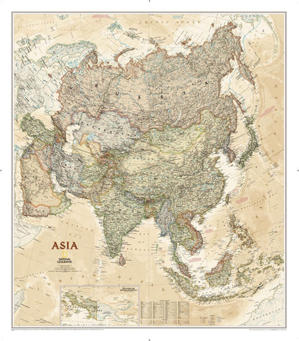
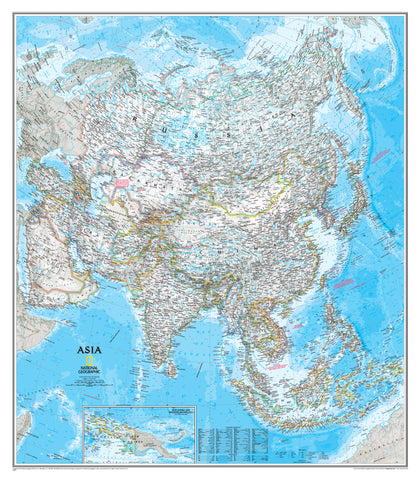
Asia Physical Atlas of the World, 11th Edition, National Geographic Wall Map
$69.95
or make 4 interest-free payments of
$17.49 AUD
fortnightly with
![]() More info
More info
National Geographic | Atlas of the World, 11th Edition
Available in Paper, Laminated, and Canvas Formats (Optional Hang Rails)
Explore the majesty of Asia's landscapes in vivid relief and timeless detail.
Step into the awe-inspiring natural world of Asia—a continent of towering mountain ranges, sprawling deserts, fertile river valleys, and dramatic coastlines—with this beautifully rendered Asia Physical Wall Map by National Geographic. Adapted from the 11th Edition of the Atlas of the World, this map captures the full physical complexity of the largest and most diverse continent on Earth.
Every ridge, plateau, and river system is presented with the signature National Geographic precision, supported by 75+ years of cartographic excellence.
Whether you’re teaching geography, planning an overland adventure, or adding a touch of scholarly elegance to your space, this map delivers beauty, accuracy, and educational value in equal measure.
🏔️ What You’ll See
| Feature | Description |
|---|---|
| 🗺️ Topographic Detail | Shaded relief highlights Asia’s mountain ranges, highlands, plateaus, and river basins |
| 🏜️ Natural Terrain | Colour-coded elevations depict deserts, forests, tundra, and lowlands |
| 🌊 Water Bodies | Major rivers, lakes, seas, and ocean bathymetry with depth shading and currents |
| 🧭 Geographic Labels | Clear, legible placement of mountains, rivers, landforms, and tectonic regions |
| 📚 Projection | Drawn using the Azimuthal Equidistant Projection for proportional distance accuracy from the centre point |
This map is designed to help viewers understand how the land shapes the people, cultures, and ecosystems of Asia.
🖼️ Premium Format Options
Choose the format that suits your purpose and aesthetic:
| Format | Features |
|---|---|
| 🖨️ Paper | Printed on 170gsm high-quality matte paper – perfect for framing under glass |
| 💧 Laminated | Gloss-laminated (80 micron both sides) – waterproof, durable, whiteboard marker-friendly |
| 🪵 Laminated + Hang Rails | Laminated with elegant timber rails – includes top cord for easy hanging |
| 🖼️ Canvas | Printed on 395gsm HP Professional Matte Canvas using archival pigment inks |
| 🪵 Canvas + Hang Rails | Canvas with hand-finished timber hang rails – ready to hang, no frame needed |
🛠️ Please allow up to 10 working days for delivery of rail-mounted maps, as these are handcrafted by our framer.
📐 Map Specifications
| Attribute | Details |
|---|---|
| Title | Asia Physical Wall Map |
| Publisher | National Geographic |
| Edition | From the Atlas of the World, 11th Edition |
| Projection | Azimuthal Equidistant |
| Map Type | Physical / Topographic |
| Dimensions | Standard: 790 mm × 610 mm Supermap: 915 mm × 1197 mm |
| Material Options | Paper, Laminated, Canvas |
| Print Origin | Proudly printed in Australia |
| Published | 2019 |
🌟 Why This Map Belongs in Your Space
✅ Authentic National Geographic cartography
✅ Elegant and educational wall décor
✅ Brilliant for classrooms, offices, libraries, and home study
✅ Visualises the Earth's natural forms with clarity and care
✅ Built to last with archival inks, premium stocks, and quality lamination or canvas finishes
🎯 Perfect For:
-
🌐 Geography classrooms and environmental education
-
🧭 Travel enthusiasts mapping out their journey through Asia
-
🏡 Home or office display with a scholarly flair
-
🎁 Gifting to map lovers, educators, or global citizens
✨ A Window to the World’s Wildest Continent
From the frozen peaks of the Himalayas to the humid jungles of Southeast Asia, this Asia Physical Wall Map offers a breathtaking panorama of landforms and natural beauty. It's more than a reference—it's a celebration of Earth's extraordinary diversity.
🛒 Add to cart now and bring the natural wonder of Asia into your home or classroom.
Frequently Asked Questions
What does the Asia Physical Atlas of the World, 11th Edition, National Geographic Wa cover?
This atlas covers the geographic region indicated in the product title, including roads, towns, distances, and key travel information. Mapworld stocks atlases for Australian states and territories, 4WD regions, and international destinations.
Is this the latest edition?
Yes, this is the 11th Edition. Mapworld stocks the most current editions available from publishers.
Is this atlas or guide spiral bound?
Spiral binding is indicated in the product title where applicable. Spiral-bound atlases and guides lay flat when open, making them ideal for use in vehicles or on a table without needing to hold pages open.
Is the Asia Physical Atlas of the World, 11th Edition, National Geographic Wa in stock at Mapworld?
Mapworld maintains extensive stock across its map range and aims for fast dispatch. Orders placed before 2pm AEST on business days are typically dispatched the same day, with standard and express Australia-wide delivery options available.
Does Mapworld ship the Asia Physical Atlas of the World, 11th Edition, National Geographic Wa across Australia?
Yes, Mapworld ships Australia-wide. Standard shipping is a flat $7 rate, with free standard shipping on orders over $75. Express options are available at checkout. Most orders placed before 2pm AEST on weekdays are dispatched same day.
Related Items

© 2026 Mapworld. Website designed by Genie Media
X