- Australia ▾
- Topographic
▾
- Australia AUSTopo 250k (2025)
- Australia 50k Geoscience maps
- Australia 100k Geoscience maps
- Australia 250k Geoscience maps
- Australia 1:1m Geoscience maps
- New Zealand 50k maps
- New Zealand 250k maps
- New South Wales 25k maps
- New South Wales 50k maps
- New South Wales 100k maps
- Queensland 10k maps
- Queensland 25k maps
- Queensland 50k maps
- Queensland 100k maps
- Western Australia 25k maps
- Western Australia 50k maps
- Western Australia 100k maps
- Compasses
- Software
- GPS Systems
- International ▾
- Wall Maps
▾
- World
- Australia & New Zealand
- Countries, Continents & Regions
- Historical
- Vintage National Geographic
- Australian Capital Territory
- New South Wales
- Northern Territory
- Queensland
- South Australia
- Tasmania
- Victoria
- Western Australia
- Celestial
- Children's
- Mining & Resources
- Wine Maps
- Healthcare
- Postcode Maps
- Electoral Maps
- Nautical ▾
- Flags
▾
- Australian Flag Sets & Banners
- Flag Bunting
- Handwavers
- Australian National Flags
- Aboriginal Flags
- Torres Strait Islander Flags
- International Flags
- Flagpoles & Accessories
- Australian Capital Territory Flags
- New South Wales Flags
- Northern Territory Flags
- Queensland Flags
- South Australia Flags
- Tasmania Flags
- Victoria Flags
- Western Australia Flags
- Gifts ▾
- Globes ▾
Dear valued customer. Please note that our checkout is not supported by old browsers. Please use a recent browser to access all checkout capabilities


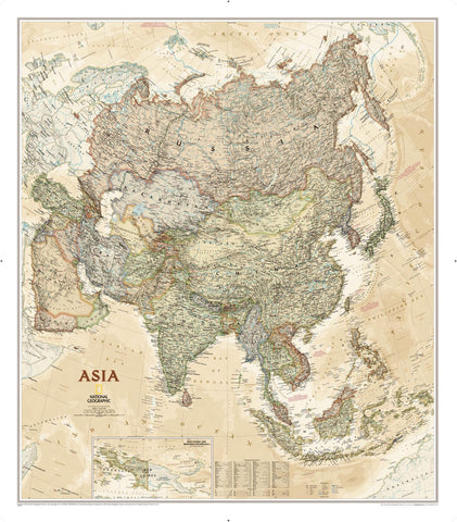
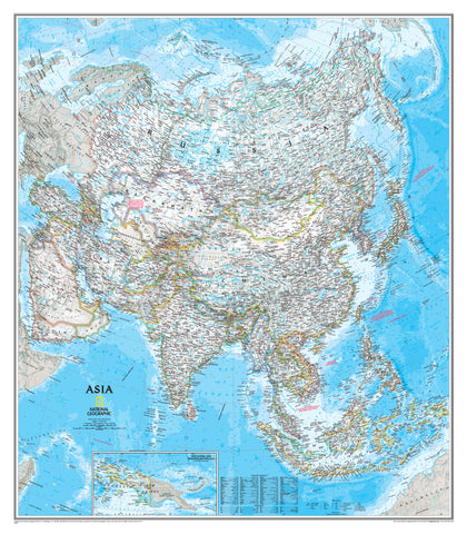
Southeast Asia National Geographic 965 x 813mm Wall Map
$79.95
or make 4 interest-free payments of
$19.99 AUD
fortnightly with
![]() More info
More info
National Geographic – Classic Political Edition
📏 Size: 965 mm (W) × 813 mm (H)
🌐 Modern borders, ancient cultures—mapped with iconic precision.
Immerse yourself in the complexity, colour, and connectivity of one of the world’s most dynamic regions with National Geographic’s Classic-Style Wall Map of Southeast Asia. With a harmonious blend of vintage styling and modern cartographic accuracy, this stunning map is both a decorative centrepiece and a functional reference for educators, travellers, businesses, and geography enthusiasts alike.
🌏 Map Features
Expertly rendered with National Geographic’s hallmark clarity and elegance, this map highlights both natural and manmade elements across the Southeast Asian landscape:
| Category | Details |
|---|---|
| 🗺️ Political Boundaries | Clearly defined international borders across all Southeast Asian nations |
| 🏙️ Place Names | Thousands of cities, towns, rivers, and islands labelled |
| 🌿 Protected Areas | National parks and ecological reserves shown in fine detail |
| 🚈 Infrastructure | Includes major roads, highways, airports, pipelines & high-speed rail lines |
| 🛰️ Special Sites | China’s Xichang Satellite Launch Centre, oil fields, ports & more |
| 🏛️ Cultural Heritage | UNESCO-listed sites like Angkor Wat in Cambodia beautifully marked |
| 🧭 Relief & Bathymetry | Shaded terrain and bathymetric ocean data bring depth and realism |
This map is not only an educational tool—it’s a conversation piece, bringing history, culture, and geography into view.
🖼️ Format Options – Tailored to Your Space
Choose the perfect finish to suit your environment—from practical classroom use to elegant home display.
| Format | Details |
|---|---|
| 🖨️ Paper | Printed on 170gsm heavyweight matte paper – ideal for framing under glass |
| 💧 Laminated | Fully encapsulated in 80-micron gloss laminate – waterproof and durable |
| 🖼️ Canvas | Printed on 395gsm HP Professional Matte Canvas – fade-resistant, gallery-worthy texture |
| 🪵 Laminated + Hang Rails | Laminated map with natural timber hang rails (top & bottom) and hanging cord |
| 🪵 Canvas + Hang Rails | Canvas map with timber hang rails – a sophisticated, ready-to-hang display |
All timber hang rail options include a satin-lacquered finish and a top cord for easy wall mounting.
Please allow 10 working days for delivery of hang-railed maps as they are custom-finished by our framer.
📐 Product Specifications
| Specification | Details |
|---|---|
| Publisher | National Geographic |
| Map Style | Classic Political |
| Map Title | Southeast Asia |
| Print Origin | Made in Australia |
| Map Size | 965 mm (W) × 813 mm (H) |
| Paper Stock | 170gsm matte (paper version) |
| Canvas Stock | 395gsm HP Professional Matte Canvas |
| Lamination | True encapsulation (2 × 80 micron gloss) |
| Inks | Pigment-based, UV-stable, fade-resistant |
🎯 Who Is This Map For?
✅ Educators & Schools – A clear, reliable visual reference for geography, history, and global studies
✅ Travel Planners & Dreamers – Trace your journey from Thailand to Timor with up-to-date infrastructure detail
✅ Business & NGOs – Ideal for regional strategy, logistics, or development planning
✅ Decorators & Designers – Adds sophistication and substance to studies, offices, and shared spaces
✅ Gift-Givers – A perfect present for global citizens, academics, or map collectors
🌟 Why Choose National Geographic Maps?
✔️ Cartographic Excellence – Trusted for over 100 years
✔️ Global Authority – The perfect marriage of beauty and accuracy
✔️ High-Quality Materials – Printed and finished to last a lifetime
✔️ Versatile Formats – Designed to suit any purpose and any wall
This map isn’t just informative—it’s inspiring. A tribute to the interconnected nations of Southeast Asia, from the mountain jungles of Laos to the islands of Indonesia, and everything in between.
🛒 Order now to bring this beautifully detailed Southeast Asia map into your world.
A celebration of geography, culture, and craftsmanship—all in one frame-worthy display.
Frequently Asked Questions
What are the dimensions of the Southeast Asia National Geographic 965 x 813mm Wall Map?
Mapworld wall maps range from standard 700×1000mm to large-format 1000×1430mm Supermaps. The exact dimensions for this map are shown in the product title. Where multiple sizes are available, select your preferred size when adding to cart.
Is this wall map available laminated?
Many Mapworld wall maps are available in paper, laminated, or framed finishes. Check the product options when adding to cart. Laminated maps are wipe-clean and more durable.
Is this the latest edition?
Mapworld stocks the most current editions available from all publishers. Edition year is shown in the product title where applicable. Mapworld updates its catalogue as new editions are released.
Can I write on or pin this wall map?
Laminated wall maps can be written on with whiteboard markers and wiped clean. Paper maps can be pinned on a corkboard. Choose a laminated option for a writeable surface.
Does Mapworld ship the Southeast Asia National Geographic 965 x 813mm Wall Map across Australia?
Yes, Mapworld ships Australia-wide. Standard shipping is a flat $7 rate, with free standard shipping on orders over $75. Express options are available at checkout. Most orders placed before 2pm AEST on weekdays are dispatched same day.
Related Items


© 2026 Mapworld. Website designed by Genie Media
X