- Australia ▾
- Topographic
▾
- Australia AUSTopo 250k (2024)
- Australia 50k Geoscience maps
- Australia 100k Geoscience maps
- Australia 250k Geoscience maps
- Australia 1.1m Geoscience maps
- New Zealand 50k maps
- New Zealand 250k maps
- New South Wales 25k maps
- New South Wales 50k maps
- New South Wales 100k maps
- Queensland 10k maps
- Queensland 25k maps
- Queensland 50k maps
- Queensland 100k maps
- Compasses
- Software
- GPS Systems
- Orienteering
- International ▾
- Wall Maps
▾
- World
- Australia & New Zealand
- Countries, Continents & Regions
- Historical
- Vintage National Geographic
- Australian Capital Territory
- New South Wales
- Northern Territory
- Queensland
- South Australia
- Tasmania
- Victoria
- Western Australia
- Celestial
- Children's
- Mining & Resources
- Wine Maps
- Healthcare
- Postcode Maps
- Electoral Maps
- Nautical ▾
- Flags
▾
- Australian Flag Sets & Banners
- Flag Bunting
- Handwavers
- Australian National Flags
- Aboriginal Flags
- Torres Strait Islander Flags
- International Flags
- Flagpoles & Accessories
- Australian Capital Territory Flags
- New South Wales Flags
- Northern Territory Flags
- Queensland Flags
- South Australia Flags
- Tasmania Flags
- Victoria Flags
- Western Australia Flags
- Gifts ▾
- Globes ▾
Dear valued customer. Please note that our checkout is not supported by old browsers. Please use a recent browser to access all checkout capabilities


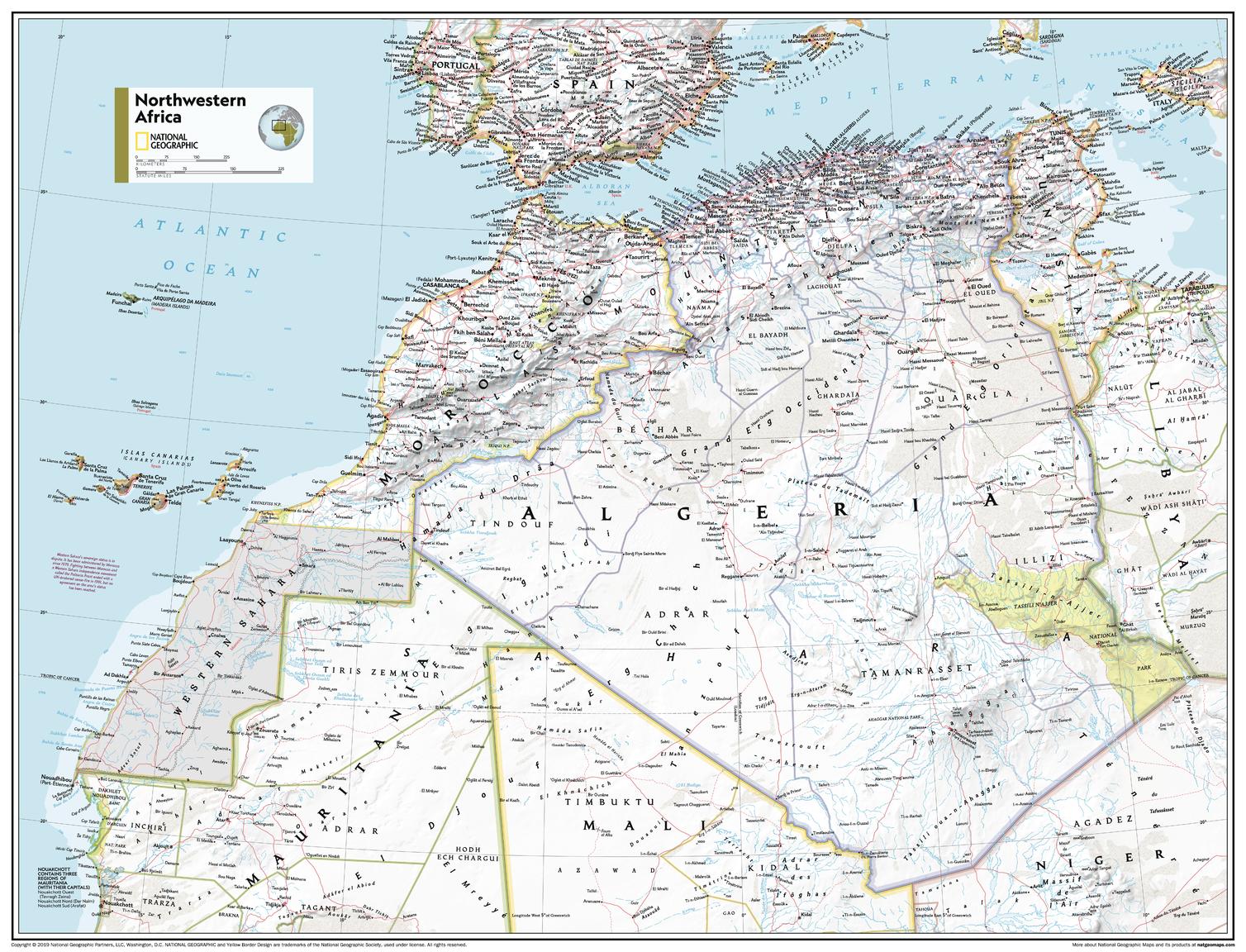
North Western Africa Atlas of the World, 11th Edition, National Geographic Wall Map
$69.95
or make 4 interest-free payments of
$17.49 AUD
fortnightly with
![]() More info
More info
National Geographic | Atlas of the World, 11th Edition
Available Sizes:
📏 Standard: 790 x 610 mm | 🗺️ Supermap: 915 x 1197 mm
From the Atlantic coast to the Sahara’s edge—experience North West Africa in rich, educational detail.
Explore the dramatic landscapes and cultural diversity of North Western Africa with this beautifully detailed National Geographic wall map, drawn from the celebrated 11th Edition Atlas of the World. Covering countries such as Morocco, Algeria, Western Sahara, Mauritania, Mali, and parts of Senegal and Niger, this map blends accurate political boundaries with vivid topographical detail, creating a compelling reference and display piece.
Whether used in a classroom, research setting, or as part of a decorative wall collection, this map provides clarity, insight, and a visual journey through one of Africa’s most striking and historically rich regions.
🗺️ Map Coverage & Features
🌍 Countries Included:
-
Morocco, Algeria, Western Sahara, Mauritania, Mali, and parts of Senegal, Niger, and Libya
🏞️ Physical Geography:
-
Vast Sahara Desert dunes and dry basins
-
Atlas Mountains with shaded elevation detail
-
Coastal plains, rivers, and oases
-
Shaded relief to highlight terrain and landforms
🗺️ Political Features:
-
Country borders, disputed territories, and administrative divisions
-
Major cities and capital locations
-
Transportation routes, major roads, and ports
-
Clear, easy-to-read place names in National Geographic’s signature style
🧭 Projection & Style:
-
Transverse Mercator Projection – excellent for regional and navigational reference
-
Bright, high-contrast colour palette featuring blue oceans, earth-toned terrain, and intuitive labelling
-
Sourced directly from National Geographic’s 11th Edition World Atlas
Ideal for teaching geography, understanding political landscapes, or simply admiring the grandeur of North Africa.
🎯 Who Should Use This Map?
✔️ Educators & Students – Perfect for geography and African studies
✔️ Linguists & Historians – Study the legacy of colonial borders and cultural exchange
✔️ Travellers & Overlanders – Trace historical caravan routes, mountain ranges, and national parks
✔️ Researchers & Policy Analysts – Useful for understanding borders, trade corridors, and climate zones
✔️ Decor Enthusiasts – A refined visual piece for libraries, offices, or map-themed spaces
🖼️ Available in Three Premium Formats
| Format | Material & Finish | Ideal For |
|---|---|---|
| Paper | 160gsm heavyweight matte paper | Perfect for framing under glass |
| Laminated | Fully encapsulated in 80-micron gloss laminate – waterproof, durable, and whiteboard-friendly | Ideal for classrooms, offices, or fieldwork |
| Canvas | 395gsm HP Matte Artist’s Canvas with pigment inks – fade-resistant and richly textured | Gallery-quality finish for professional and decorative settings |
➕ Optional timber hang rails available for laminated and canvas versions.
🪵 Timber Hang Rails – Optional Display Upgrade
Transform your map into a ready-to-hang, refined wall piece:
-
🪚 Handcrafted timber rails with a satin lacquer finish
-
🧵 Corded top rail for simple mounting
-
🖐️ Custom-fitted by our professional framer
-
⏳ Please allow 10 working days for rail-mounted formats to ship
Make your map a statement piece with this tasteful finishing touch.
📐 Specifications
| Feature | Details |
|---|---|
| Title | North Western Africa Wall Map |
| Publisher | National Geographic |
| Edition | Atlas of the World, 11th Edition |
| Published | 2019 |
| Projection | Transverse Mercator |
| Map Style | Political & Physical |
| Standard Size | 790 mm (W) x 610 mm (H) |
| Supermap Size | 915 mm (W) x 1197 mm (H) |
| Optional Extras | Timber hang rails (Laminated & Canvas formats only) |
| Print Origin | Printed and finished in Australia |
💡 Why Choose This Map?
✅ Up-to-date and expertly designed by National Geographic cartographers
✅ Ideal for educational and professional use—as well as decorative environments
✅ Visually intuitive—perfect for students and general readers alike
✅ Printed on premium materials for durability and archival quality
✅ Connects physical geography with modern political understanding
Let the North Western Africa Wall Map be your gateway to one of the most storied and visually striking regions of the world—spanning desert, mountain, and coast in stunning detail.
📦 Shipping & Handling
-
📄 Paper, Laminated & Canvas maps: Ships in 1–2 business days
-
🖼️ Hang Rail versions: Please allow 7–10 business days for custom finishing
🛒 Add to Cart – Discover the Beauty and Complexity of North West Africa
Whether for education, research, or decoration, this map delivers the accuracy and artistry only National Geographic can provide.


