- Australia ▾
- Topographic
▾
- Australia AUSTopo 250k (2024)
- Australia 50k Geoscience maps
- Australia 100k Geoscience maps
- Australia 250k Geoscience maps
- Australia 1.1m Geoscience maps
- New Zealand 50k maps
- New Zealand 250k maps
- New South Wales 25k maps
- New South Wales 50k maps
- New South Wales 100k maps
- Queensland 10k maps
- Queensland 25k maps
- Queensland 50k maps
- Queensland 100k maps
- Compasses
- Software
- GPS Systems
- Orienteering
- International ▾
- Wall Maps
▾
- World
- Australia & New Zealand
- Countries, Continents & Regions
- Historical
- Vintage National Geographic
- Australian Capital Territory
- New South Wales
- Northern Territory
- Queensland
- South Australia
- Tasmania
- Victoria
- Western Australia
- Celestial
- Children's
- Mining & Resources
- Wine Maps
- Healthcare
- Postcode Maps
- Electoral Maps
- Nautical ▾
- Flags
▾
- Australian Flag Sets & Banners
- Flag Bunting
- Handwavers
- Australian National Flags
- Aboriginal Flags
- Torres Strait Islander Flags
- International Flags
- Flagpoles & Accessories
- Australian Capital Territory Flags
- New South Wales Flags
- Northern Territory Flags
- Queensland Flags
- South Australia Flags
- Tasmania Flags
- Victoria Flags
- Western Australia Flags
- Gifts ▾
- Globes ▾
Dear valued customer. Please note that our checkout is not supported by old browsers. Please use a recent browser to access all checkout capabilities


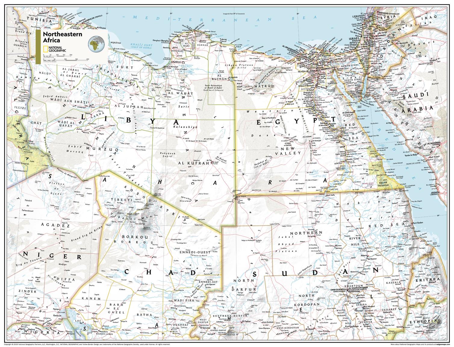
North Eastern Africa Atlas of the World, 11th Edition, National Geographic Wall Map
$69.95
or make 4 interest-free payments of
$17.49 AUD
fortnightly with
![]() More info
More info
National Geographic | Atlas of the World, 11th Edition
Available Sizes:
📏 Standard: 790 x 610 mm | 🗺️ Supermap: 915 x 1197 mm
From the Nile to the Red Sea—explore Africa’s most complex and dynamic region in vivid detail.
Bring one of the world’s most geopolitically and ecologically significant regions into sharp focus with this North Eastern Africa Wall Map—expertly rendered by the award-winning cartographers at National Geographic. Combining up-to-date political information with stunning physical topography, this map offers an exceptional overview of the Horn of Africa, Nile River Basin, and surrounding territories.
Whether you're an educator, researcher, student, or simply someone who values precision and beauty in cartography, this map serves as a comprehensive reference, a rich visual teaching tool, and an elegant wall display.
🗺️ Coverage & Cartographic Features
This map includes a detailed view of the northeastern quadrant of the African continent, portraying a wide range of physical and human geography:
📍 Countries Featured:
-
Egypt
-
Sudan & South Sudan
-
Eritrea
-
Ethiopia
-
Djibouti
-
Somalia
-
Portions of Kenya, Uganda, and Yemen
🏞️ Physical Geography:
-
The Nile River system and its tributaries, including Blue & White Nile
-
The Red Sea coastline and the Great Rift Valley
-
Ethiopian Highlands, Lake Tana, Lake Turkana, and desert zones
-
Shaded relief shows terrain, elevation, and geologic forms
🗺️ Political Geography:
-
Clearly defined international boundaries and disputed territories
-
Country names, capital cities, and major towns
-
Key transportation networks, including roads, ports, and railways
🧭 Projection & Style:
-
Transverse Mercator Projection: Maintains scale and directional accuracy—ideal for regional and navigational reference
-
Bright, high-contrast palette with blue oceans, clear typography, and distinct shading
-
Drawn from the authoritative 11th Edition of National Geographic’s Atlas of the World
Perfectly balances political structure with physical reality—making it both a classroom essential and a décor centrepiece.
🎯 Who Is This Map For?
✔️ Educators & Teachers – Teaching physical geography, African studies, environmental science, or geopolitics
✔️ Students & Researchers – Studying Nile Basin water conflicts, migration patterns, or Horn of Africa development
✔️ Policy & NGO Offices – Ideal for those working in humanitarian, environmental, or diplomatic roles
✔️ Home & Office Display – Adds thoughtful global context to your wall, library, or study
✔️ Collectors & Map Enthusiasts – A rare regional view from one of the world’s most respected map publishers
🖼️ Available in Three Premium Formats
| Format | Material & Finish | Ideal For |
|---|---|---|
| Paper | 160gsm heavyweight matte paper | For framing under glass—clean, elegant finish for home or office |
| Laminated | Gloss-laminated on both sides (80-micron encapsulation) – waterproof and durable | Perfect for classrooms or planning environments using whiteboard markers |
| Canvas | 395gsm HP Matte Artist’s Canvas with pigment inks – fade-resistant and richly textured | Museum-quality finish for long-term display in professional or curated spaces |
All formats are printed in Australia using archival-quality pigment inks for long-lasting clarity and colour.
🪵 Optional Timber Hang Rails – Make It Wall-Ready
Add a polished, display-ready look with our optional handcrafted timber hang rails (available for laminated and canvas formats):
-
🪚 Satin-lacquered natural timber, designed to complement any space
-
🧵 Corded top rail included for quick and easy wall mounting
-
🖐️ Hand-fitted by our professional framer to ensure perfect alignment
-
⏳ Please allow up to 10 working days for framed and hang-railed map delivery
The perfect blend of style and substance—your map becomes a conversation piece.
📐 Full Specifications
| Specification | Details |
|---|---|
| Map Title | North Eastern Africa Wall Map |
| Publisher | National Geographic |
| Edition | Atlas of the World, 11th Edition |
| Published | 2019 |
| Projection | Transverse Mercator |
| Map Style | Physical & Political |
| Standard Size | 790 mm (W) x 610 mm (H) |
| Supermap Size | 915 mm (W) x 1197 mm (H) |
| Format Options | Paper, Laminated, or Canvas |
| Optional Extras | Timber hang rails (Laminated & Canvas formats only) |
| Printed In | Australia |
💡 Why Choose This Map?
✅ Classroom-Ready – Combines key elements of both political and physical geography in an intuitive format
✅ Visually Stunning – National Geographic’s palette and typography have set the global standard in cartographic design
✅ Geopolitically Relevant – Covers some of Africa’s most important natural resources, migration routes, and international borders
✅ Made to Last – Printed with fade-resistant pigment inks on durable, high-quality substrates
✅ A Legacy of Excellence – Part of the same cartographic tradition that’s informed generations through National Geographic publications
Let the North Eastern Africa Wall Map bring the richness of this diverse and strategically vital region to life. Whether for teaching, research, planning, or décor—this is a map you’ll return to again and again.
📦 Shipping & Delivery
-
📄 Paper, Laminated & Canvas maps: Ship within 1–2 business days
-
🖼️ Hang Rail versions: Please allow 7–10 business days for custom assembly and dispatch
-
🌍 Ships worldwide from our Australian warehouse
🛒 Add to Cart – Explore Africa’s Heartbeat in Stunning Detail
Discover where cultures converge, rivers carve valleys, and history is always in motion—on the wall, in your hands, and at your fingertips.


