- Australia ▾
- Topographic
▾
- Australia AUSTopo 250k (2024)
- Australia 50k Geoscience maps
- Australia 100k Geoscience maps
- Australia 250k Geoscience maps
- Australia 1.1m Geoscience maps
- New Zealand 50k maps
- New Zealand 250k maps
- New South Wales 25k maps
- New South Wales 50k maps
- New South Wales 100k maps
- Queensland 10k maps
- Queensland 25k maps
- Queensland 50k maps
- Queensland 100k maps
- Compasses
- Software
- GPS Systems
- Orienteering
- International ▾
- Wall Maps
▾
- World
- Australia & New Zealand
- Countries, Continents & Regions
- Historical
- Vintage National Geographic
- Australian Capital Territory
- New South Wales
- Northern Territory
- Queensland
- South Australia
- Tasmania
- Victoria
- Western Australia
- Celestial
- Children's
- Mining & Resources
- Wine Maps
- Healthcare
- Postcode Maps
- Electoral Maps
- Nautical ▾
- Flags
▾
- Australian Flag Sets & Banners
- Flag Bunting
- Handwavers
- Australian National Flags
- Aboriginal Flags
- Torres Strait Islander Flags
- International Flags
- Flagpoles & Accessories
- Australian Capital Territory Flags
- New South Wales Flags
- Northern Territory Flags
- Queensland Flags
- South Australia Flags
- Tasmania Flags
- Victoria Flags
- Western Australia Flags
- Gifts ▾
- Globes ▾
Dear valued customer. Please note that our checkout is not supported by old browsers. Please use a recent browser to access all checkout capabilities


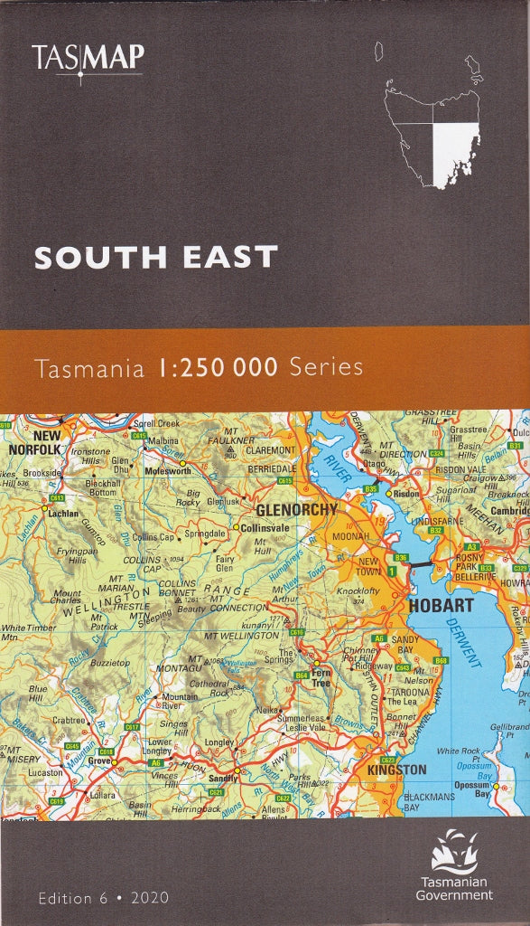
Tasmania South East Tasmap Map
$19.95
Afterpay is only available for orders between $50.00 and $1000.00 More info
🗺️ South East Tasmania – TASMAP 1:250,000 Regional Series
Explore Tasmania’s historic heartland, rugged coastlines, and wild hinterlands
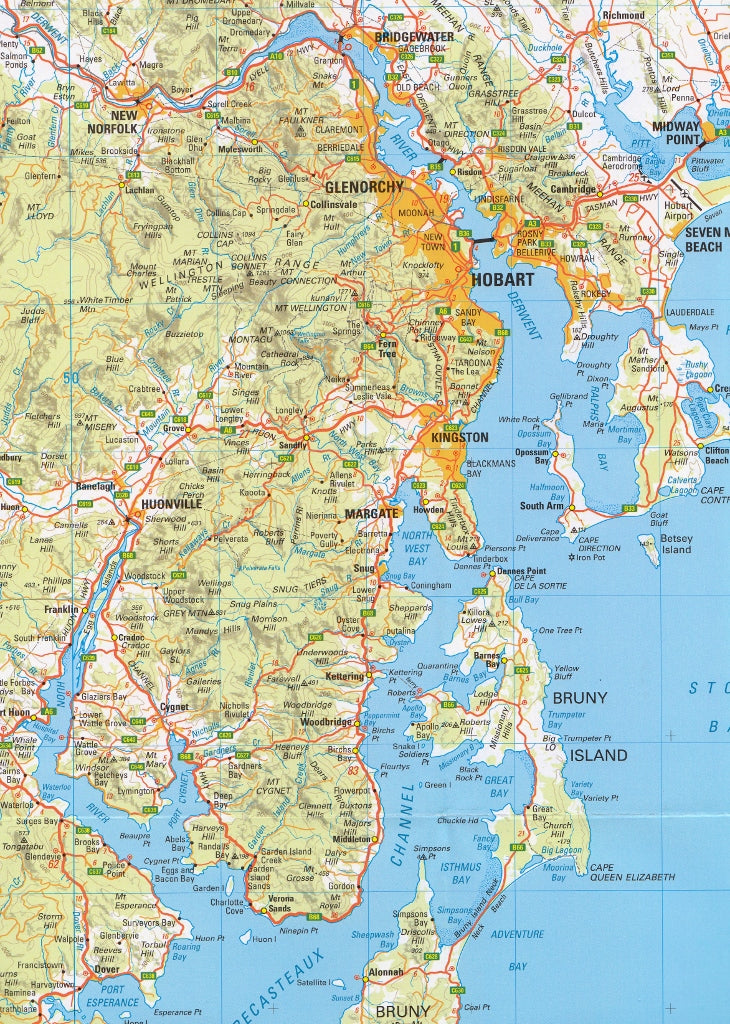
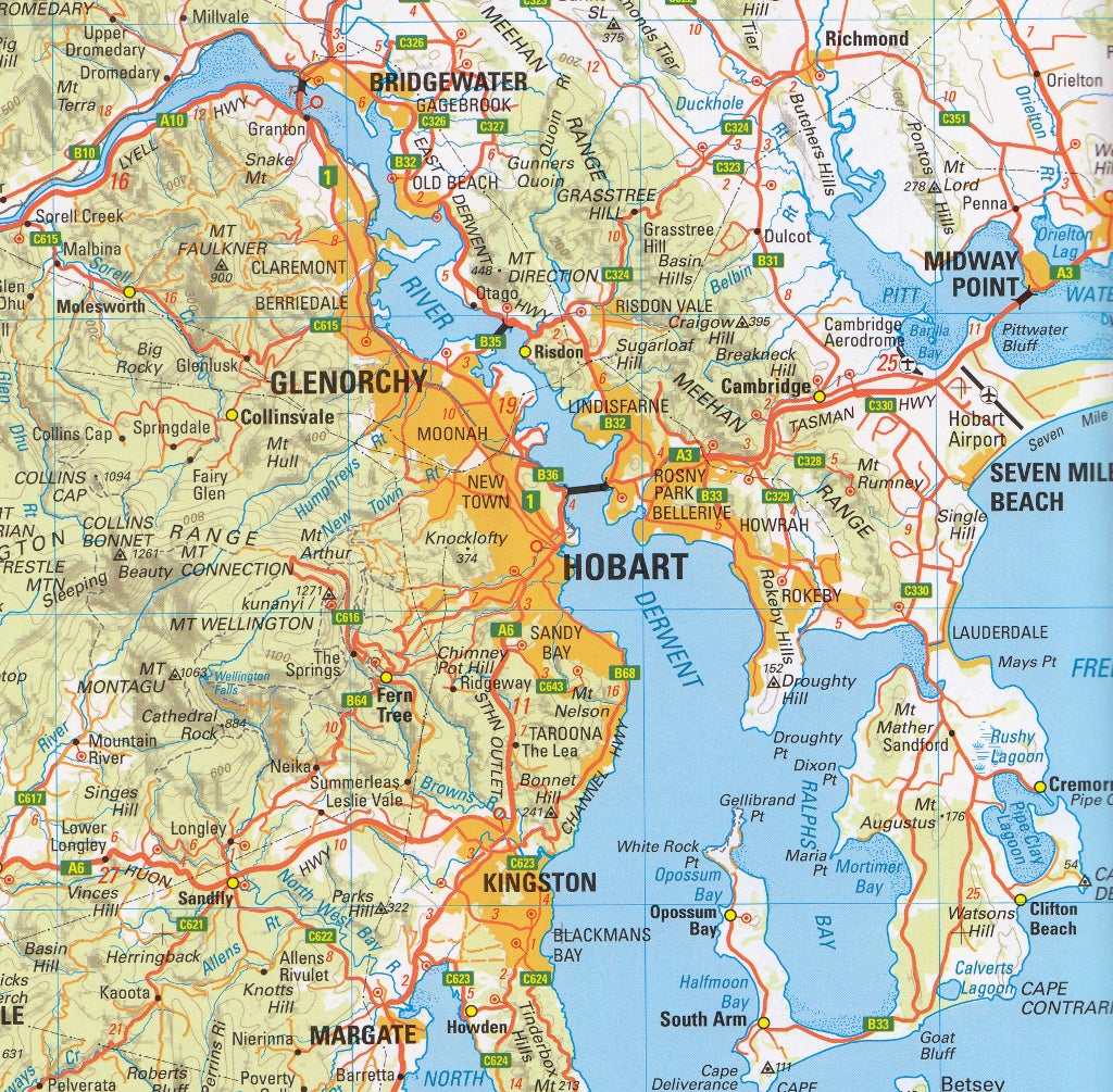
The South East Tasmania Map from TASMAP is part of a comprehensive four-map regional series that covers all of Tasmania — including Macquarie Island and King Island as insets. This edition provides detailed coverage of southeastern Tasmania, encompassing the state capital Hobart, the Tasman Peninsula, Huon Valley, Bruny Island, and extending north into the Midlands and beyond.
Whether you’re planning a scenic drive, conducting land use research, or exploring Tasmania’s rich colonial and natural heritage, this topographic map offers the scale and clarity needed to confidently navigate the region.
📍 Regional Coverage Includes:
-
Hobart and surrounds
-
Richmond, New Norfolk, Cygnet, and Huonville
-
Bruny Island and D’Entrecasteaux Channel
-
Tasman Peninsula including Port Arthur Historic Site
-
Sorell, Triabunna, Orford, and Maria Island
-
Inland access to the Midlands Highway, Bothwell, and Campbell Town
🧭 Map Features
✅ Scale: 1:250,000
A balanced scale ideal for regional route planning, touring, and outdoor activity.
✅ Topographic Relief
-
Contour intervals at 100 metres
-
Hypsometric tinting and hillshading visualise elevation and terrain — perfect for understanding mountainous or coastal areas
✅ Road Network Details
-
Roads are categorised by surface type (sealed, unsealed, 4WD access)
-
Includes main highways, minor roads, and remote backroads
-
Distance markers assist with journey planning between towns and junctions
✅ Points of Interest & Natural Features
-
National parks and nature reserves
-
Coastal lookouts, bushwalking trails, and picnic spots
-
Rivers, lakes, and coastline detail
-
Heritage and historic sites, including World Heritage areas
✅ Inset Maps
Includes additional insets of Macquarie Island and King Island, offering a full view of Tasmania’s landmass for broader understanding and planning
📐 Product Specifications
| Feature | Details |
|---|---|
| Title | South East Tasmania – TASMAP |
| Series | TASMAP 1:250,000 Regional Series |
| Scale | 1:250,000 |
| Contours | 100m vertical interval |
| Inset Maps | Macquarie Island, King Island |
| Map Size | Folded sheet (large unfolded format) |
| Material | High-quality paper (lamination optional) |
| Published by | TASMAP (Land Tasmania) |
| Printed in | Australia |
🎯 Perfect For:
-
🚗 Scenic drivers and regional explorers
-
🚴 Cyclists mapping long-distance rides or backroads
-
🧭 Hikers and walkers exploring forest reserves and national parks
-
📊 Planners, researchers, and educators needing large-scale terrain info
-
🏕️ Campers and 4WD travellers venturing off common tourist routes
-
📚 Students and locals wanting a detailed map of their area
🧱 Optional Lamination
For rugged use, the map is also available laminated between two sheets of 80-micron gloss plastic. This option is:
-
💦 Waterproof and tear-resistant
-
✍️ Writable with whiteboard or permanent markers
-
🧳 Ideal for field trips, dashboards, or campsite planning
🌿 Discover Tasmania’s Southeastern Secrets
From the windswept cliffs of Cape Raoul to the tranquil waterways of the Huon, South East Tasmania is rich in natural beauty, cultural depth, and historical significance. Whether you're tracing the footsteps of convicts, planning a Bruny Island escape, or cruising past rolling vineyards and coastal headlands, this map is your trusted guide.
Get off the beaten track — with TASMAP South East Tasmania.