- Australia ▾
- Topographic
▾
- Australia AUSTopo 250k (2024)
- Australia 50k Geoscience maps
- Australia 100k Geoscience maps
- Australia 250k Geoscience maps
- Australia 1.1m Geoscience maps
- New Zealand 50k maps
- New Zealand 250k maps
- New South Wales 25k maps
- New South Wales 50k maps
- New South Wales 100k maps
- Queensland 10k maps
- Queensland 25k maps
- Queensland 50k maps
- Queensland 100k maps
- Compasses
- Software
- GPS Systems
- Orienteering
- International ▾
- Wall Maps
▾
- World
- Australia & New Zealand
- Countries, Continents & Regions
- Historical
- Vintage National Geographic
- Australian Capital Territory
- New South Wales
- Northern Territory
- Queensland
- South Australia
- Tasmania
- Victoria
- Western Australia
- Celestial
- Children's
- Mining & Resources
- Wine Maps
- Healthcare
- Postcode Maps
- Electoral Maps
- Nautical ▾
- Flags
▾
- Australian Flag Sets & Banners
- Flag Bunting
- Handwavers
- Australian National Flags
- Aboriginal Flags
- Torres Strait Islander Flags
- International Flags
- Flagpoles & Accessories
- Australian Capital Territory Flags
- New South Wales Flags
- Northern Territory Flags
- Queensland Flags
- South Australia Flags
- Tasmania Flags
- Victoria Flags
- Western Australia Flags
- Gifts ▾
- Globes ▾
Dear valued customer. Please note that our checkout is not supported by old browsers. Please use a recent browser to access all checkout capabilities


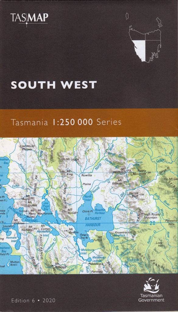
Tasmania South West Tasmap Map
$19.95
Afterpay is only available for orders between $50.00 and $1000.00 More info
🗺️ South West Tasmania – TASMAP 1:250,000 Regional Map
Your essential topographic guide to Tasmania’s most remote and untamed wilderness
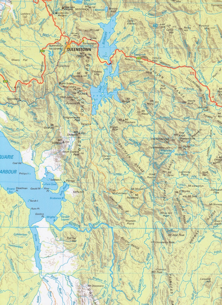
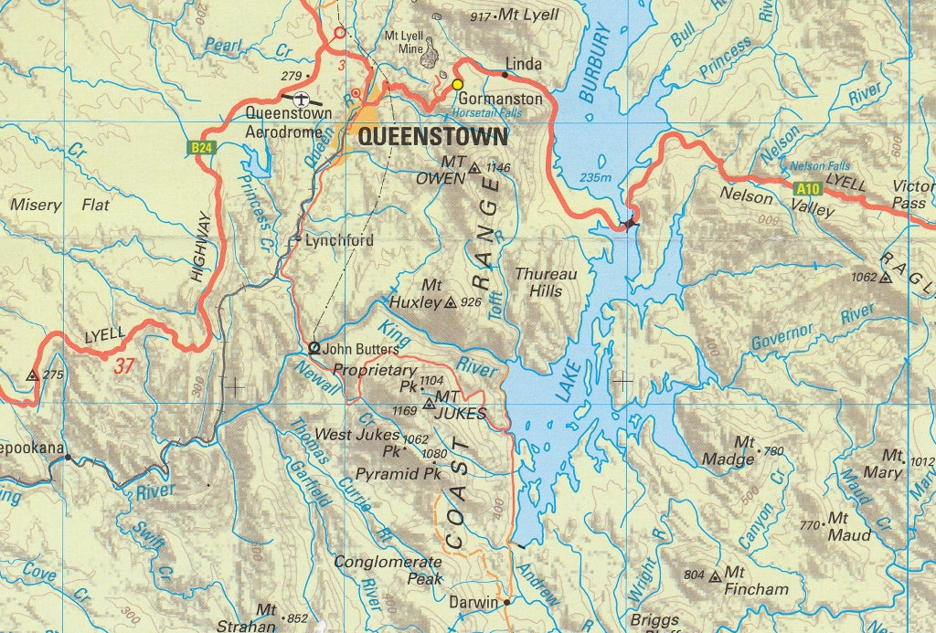
The South West Tasmania Map by TASMAP is part of a four-map regional series that covers the entirety of Tasmania, including Macquarie Island and King Island as insets. This map focuses on the southwestern quadrant of the state — a region defined by rugged coastlines, wild rivers, vast mountain ranges, and some of the most pristine wilderness remaining on Earth.
Covering approximately 37,000 square kilometres, this detailed topographic map is ideal for regional planning, remote travel, bushwalking, and eco-tourism. It offers an unparalleled view of a landscape shaped by time and protected by conservation efforts.
📍 Area Coverage
-
Southwest National Park (Tasmania’s largest protected area)
-
Lake Pedder and Gordon River systems
-
Port Davey and Bathurst Harbour
-
Strathgordon, Gees Marsh, and Scotts Peak Dam
-
Mount Anne, Mount Wedge, and Frankland Range
-
Remote coastline including Maatsuyker Island and Precipitous Bluff
-
Parts of the Western Arthur Range, South Coast Track, and Frenchmans Cap area
🧭 Key Features
✅ Scale: 1:250,000
Perfect for route planning and large-scale terrain awareness across vast, remote areas.
✅ Topographic Detail
-
100 metre contour intervals
-
Hillshading and hypsometric tinting enhance landform visibility
-
Aids in understanding elevation and navigation in alpine and gorge terrain
✅ Road & Track Network
-
Roads colour-coded by surface type and network hierarchy
-
Major and minor access roads, plus unsealed tracks into remote regions
-
Distance markers between towns and major junctions for efficient planning
✅ Natural & Cultural Landmarks
-
National parks, nature reserves, World Heritage-listed areas
-
Remote walking trails, rivers, lakes, and wilderness campsites
-
Includes points of cultural, historical, and environmental interest
✅ Inset Maps
-
Macquarie Island and King Island
-
Offers complete state context across all four quadrants
📐 Product Specifications
| Feature | Details |
|---|---|
| Title | South West Tasmania – TASMAP |
| Series | TASMAP 1:250,000 Regional Map Series |
| Scale | 1:250,000 |
| Contours | 100m vertical interval |
| Inset Maps | Macquarie Island, King Island |
| Material | High-quality paper (lamination optional) |
| Map Size | Large folded sheet |
| Publisher | TASMAP (Land Tasmania) |
| Printed in | Australia |
🎯 Ideal For:
-
🧭 Hikers and wilderness adventurers exploring the South Coast Track or Port Davey Track
-
🛶 Kayakers and eco-tourists visiting Bathurst Harbour or Melaleuca
-
🚗 Road trippers and 4WD travellers heading into Strathgordon and the Southwest wilderness
-
🌿 Nature photographers and researchers documenting Tasmania’s untouched environments
-
🗺️ Educators and planners needing terrain and conservation boundary detail
-
📊 Land managers and regional developers working in southwest Tasmania
🧱 Optional Lamination
For fieldwork or outdoor use, this map is also available laminated between 80-micron gloss plastic sheets, making it:
-
💦 Waterproof and tear-resistant
-
✍️ Writable with non-permanent markers
-
🏕️ Perfect for basecamps, dashboards, or weather-exposed navigation
🌄 Explore Tasmania’s Last Great Wilderness
The South West is one of the last truly wild frontiers — a landscape of towering ranges, ancient forests, glacial valleys, and storm-lashed coastlines. It's a place where nature still reigns, where explorers find solitude, and where the silence of the wilderness speaks louder than words.
Let the TASMAP South West guide you through it — with accuracy, resilience, and insight.