- Australia ▾
- Topographic
▾
- Australia AUSTopo 250k (2024)
- Australia 50k Geoscience maps
- Australia 100k Geoscience maps
- Australia 250k Geoscience maps
- Australia 1.1m Geoscience maps
- New Zealand 50k maps
- New Zealand 250k maps
- New South Wales 25k maps
- New South Wales 50k maps
- New South Wales 100k maps
- Queensland 10k maps
- Queensland 25k maps
- Queensland 50k maps
- Queensland 100k maps
- Compasses
- Software
- GPS Systems
- Orienteering
- International ▾
- Wall Maps
▾
- World
- Australia & New Zealand
- Countries, Continents & Regions
- Historical
- Vintage National Geographic
- Australian Capital Territory
- New South Wales
- Northern Territory
- Queensland
- South Australia
- Tasmania
- Victoria
- Western Australia
- Celestial
- Children's
- Mining & Resources
- Wine Maps
- Healthcare
- Postcode Maps
- Electoral Maps
- Nautical ▾
- Flags
▾
- Australian Flag Sets & Banners
- Flag Bunting
- Handwavers
- Australian National Flags
- Aboriginal Flags
- Torres Strait Islander Flags
- International Flags
- Flagpoles & Accessories
- Australian Capital Territory Flags
- New South Wales Flags
- Northern Territory Flags
- Queensland Flags
- South Australia Flags
- Tasmania Flags
- Victoria Flags
- Western Australia Flags
- Gifts ▾
- Globes ▾
Dear valued customer. Please note that our checkout is not supported by old browsers. Please use a recent browser to access all checkout capabilities


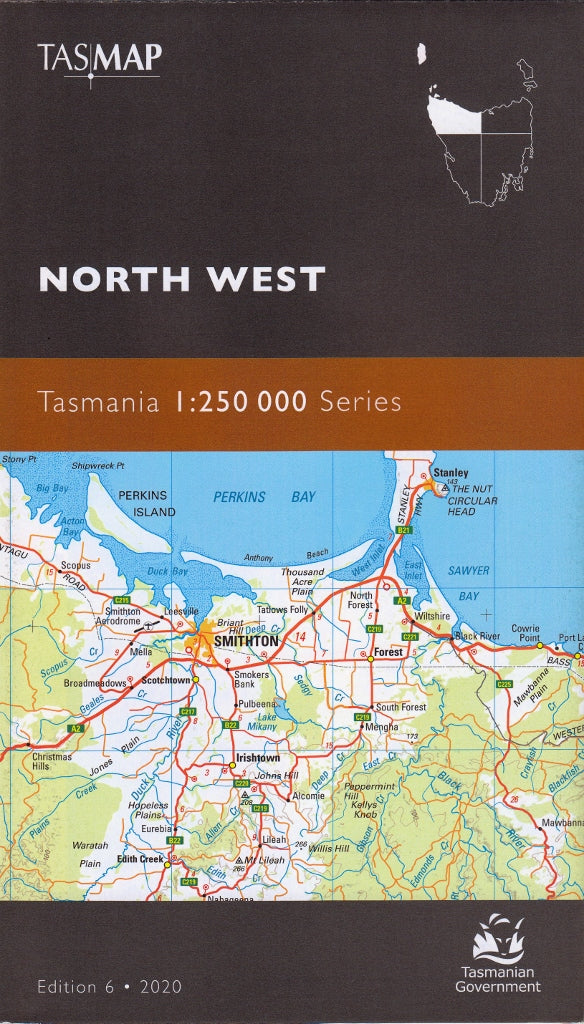
Tasmania North West Tasmap Map
$19.95
Afterpay is only available for orders between $50.00 and $1000.00 More info
🗺️ North West Tasmania Map – TASMAP 1:250,000 Regional Series
The perfect tool for exploring Tasmania’s wild northwest, beyond the tourist trail
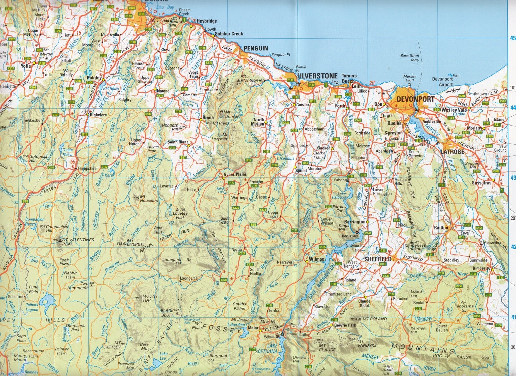
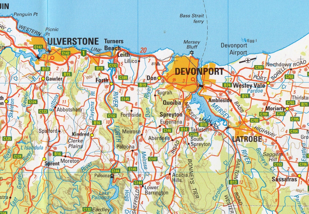
The North West Tasmania Map from TASMAP is one of four expertly crafted regional maps that together cover the entirety of Tasmania, including Macquarie Island and King Island as insets. This sheet focuses on the rugged and diverse northwest region — a place of rich history, temperate rainforests, dramatic coastlines, and remote highlands.
With a generous coverage of approximately 37,000 square kilometres, this map is designed for those who want to explore more than just Tasmania’s highways. Whether you're a regional planner, a cyclist seeking scenic backroads, or a traveller venturing into the state’s lesser-known corners, this map offers clear and accurate detail in a practical format.
📍 Regional Coverage Includes:
-
Devonport, Burnie, Ulverstone, and the North West Coast
-
Stanley, Smithton, and the Tarkine wilderness region
-
Waratah, Savage River, and other mining heritage towns
-
Cradle Mountain–Lake St Clair National Park (northwestern corner)
-
King Island and Macquarie Island (as detailed inset maps)
🧭 Key Map Features
✅ Scale: 1:250,000
Perfect for trip planning, regional touring, or backroad exploration
✅ Topographic Representation
-
Contours at 100-metre vertical intervals
-
Hillshading and hypsometric tinting to visualise terrain, elevation, and landscape variation
-
Ideal for hikers, cyclists, and anyone needing terrain insight
✅ Road Classification & Navigation Aids
-
Roads symbolised by surface type (sealed, unsealed, 4WD, etc.) and network importance
-
Distance markers between towns and intersections support precise navigation
-
Inset index of towns and key locations
✅ Points of Interest
-
National Parks and reserves
-
Scenic lookouts and natural landmarks
-
Waterways, rivers, and lakes
-
Visitor centres and recreation areas
-
Locality names and historical sites
📐 Map Specifications
| Feature | Details |
|---|---|
| Title | North West Tasmania – TASMAP |
| Series | 1:250,000 Regional Map Series |
| Scale | 1:250,000 |
| Contours | 100m vertical interval |
| Inset Maps | King Island, Macquarie Island |
| Material | Premium paper (optional lamination) |
| Map Size | Standard folded format (full-size sheet) |
| Publisher | TASMAP (Tasmanian Government) |
| Printed in | Australia |
🎯 Ideal For:
-
🚗 Self-drive tourists looking to get off the beaten path
-
🚴♂️ Cyclists navigating long-distance routes and climbs
-
🧭 Regional planners and geographers needing large-area terrain data
-
🏕️ Hikers and campers planning expeditions into reserves and parks
-
🛻 4WD explorers scouting access to wild or coastal zones
-
📚 Educational use in schools and universities
🧱 Optional Lamination
For those taking their maps into the field, we offer full lamination in 80-micron gloss plastic — making the map:
-
💧 Water-resistant and tear-proof
-
✍️ Writable with whiteboard or permanent markers
-
🏕️ Ideal for camping tables, dashboards, and rugged conditions
🌿 Explore Tasmania’s Untamed Northwest
From the windswept shores of King Island to the dense forests of the Tarkine, the northwest of Tasmania is a region of contrasts — and a paradise for explorers. This map is your key to unlocking the rich tapestry of remote towns, winding mountain roads, and natural wonders that make this part of the island so unforgettable.
Discover what lies beyond the highway — with the TASMAP North West Tasmania Map.