- Australia ▾
- Topographic
▾
- Australia AUSTopo 250k (2025)
- Australia 50k Geoscience maps
- Australia 100k Geoscience maps
- Australia 250k Geoscience maps
- Australia 1:1m Geoscience maps
- New Zealand 50k maps
- New Zealand 250k maps
- New South Wales 25k maps
- New South Wales 50k maps
- New South Wales 100k maps
- Queensland 10k maps
- Queensland 25k maps
- Queensland 50k maps
- Queensland 100k maps
- Western Australia 25k maps
- Western Australia 50k maps
- Western Australia 100k maps
- Compasses
- Software
- GPS Systems
- International ▾
- Wall Maps
▾
- World
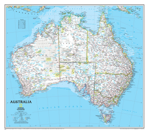
- Australia & New Zealand
- Countries, Continents & Regions
- Historical
- Vintage National Geographic
- Australian Capital Territory
- New South Wales
- Northern Territory
- Queensland
- South Australia
- Tasmania
- Victoria
- Western Australia
- Celestial
- Children's
- Mining & Resources
- Wine Maps
- Healthcare
- Postcode Maps
- Electoral Maps
- Nautical ▾
- Flags
▾
- Australian Flag Sets & Banners
- Flag Bunting
- Handwavers
- Australian National Flags
- Aboriginal Flags
- Torres Strait Islander Flags
- International Flags
- Flagpoles & Accessories
- Australian Capital Territory Flags
- New South Wales Flags
- Northern Territory Flags
- Queensland Flags
- South Australia Flags
- Tasmania Flags
- Victoria Flags
- Western Australia Flags
- Gifts ▾
- Globes ▾
Dear valued customer. Please note that our checkout is not supported by old browsers. Please use a recent browser to access all checkout capabilities


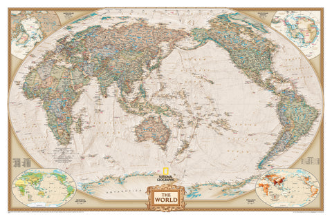
World Executive Antique Style Wall Maps by National Geographic
$89.95
or make 4 interest-free payments of
$22.49 AUD
fortnightly with
![]() More info
More info
A richly detailed and classically styled world map that blends timeless aesthetics with contemporary accuracy — perfect for display, reference, and inspiration
The World Executive Political Map from National Geographic is a cartographic masterpiece that combines modern geopolitical accuracy with the elegance of antique design. This edition, presented in warm earth-tone colours, evokes the golden age of exploration and mapmaking while remaining completely current in its political boundaries and international data.
More than just a map, this piece is a visual anchor for any room — a distinguished and educational focal point that inspires curiosity, sparks conversation, and brings the world to your wall in spectacular detail. Whether in a home study, executive boardroom, public library, or school classroom, this map is equally at home among bookshelves and whiteboards as it is beside framed artwork.
🌍 Map Highlights and Cartographic Detail
-
Updated Political Data: Reflects the most recent country boundaries, capital cities, and geopolitical shifts with the renowned accuracy of National Geographic cartographers.
-
Winkel Tripel Projection: Chosen by National Geographic for its ability to balance size and shape, this projection minimizes distortion and offers a more accurate overall view of the world than many traditional projections (such as Mercator).
-
Antique-Inspired Styling: The soft, earthy colour palette of browns, beiges, creams, and muted greens blends beautifully with classic or contemporary interiors, creating an atmosphere of depth, warmth, and sophistication.
-
Detailed Relief and Ocean Shading: Subtle hill shading and ocean floor contours give a sense of topography and underwater features, bringing the land and sea to life.
-
Inset Thematic Maps: Located in the lower corners of the map are smaller thematic maps that provide additional global context:
-
Population density
-
Land use patterns
-
Vegetation zones
-
-
Dual-Centred Options:
-
Africa-Centred Projection: Offers a traditional world layout with Europe and Africa centrally positioned.
-
Pacific-Centred Projection: Ideal for viewers in the Asia-Pacific region — especially Australia and New Zealand — this version presents a less Eurocentric view of the globe.
-
📐 Available Sizes:
-
Small: 1100 mm (W) x 780 mm (H)
-
Large: 1540 mm (W) x 1020 mm (H)
Each size provides exceptional clarity, with text and borders that are legible even from a distance — making it functional for both close-up study and wall-mounted display.
🖨️ Print and Finish Options
🧾 160 gsm Paper (Unlaminated)
-
Ideal for custom framing under glass
-
Smooth matte finish enhances colour and legibility
-
Recommended for formal interiors, studies, offices, or gallery walls
🧽 Laminated – Encapsulated (Gloss Finish)
-
Printed on heavyweight paper and encased between two 80-micron gloss laminate sheets
-
Resistant to water, stains, and tears
-
Suitable for frequent handling or use with whiteboard markers
-
Perfect for classrooms, workshops, travel planning, or anywhere you want a durable, interactive surface
🖼️ Canvas (395 gsm HP Matte Canvas)
-
Printed using fade-resistant, pigment-based inks
-
Offers a rich, textured finish with museum-quality clarity
-
Flexible and highly durable — perfect for long-term, frameless display
-
Makes a stunning gift or statement piece for world travellers, educators, or design-conscious cartophiles
🪵 Wooden Hanging Rails (Canvas Only)
For an elegant, frameless display, canvas maps can be fitted with natural timber hang rails, lacquered for a smooth finish.
-
Top and bottom rails keep the map flat and taut
-
Hanging cord included on the top rail — simply hook on a wall for instant installation
-
Suitable for home, office, or classroom environments where a classic look is preferred
-
Note: Please allow up to 10 working days for framed or hang-railed canvas maps, as these are hand-mounted to order by our in-house framer.
🎯 Ideal For:
-
Interior Designers & Decorators: Adds a classic, intellectual touch to home offices, libraries, living rooms, and waiting areas.
-
Educators & Students: A powerful learning tool that engages both the eye and the mind.
-
Executives & Professionals: Elevates corporate offices, meeting rooms, and reception areas with sophistication and global awareness.
-
Travellers & Collectors: Inspires wanderlust while providing a beautiful way to track adventures and plan future journeys.
-
Gift Givers: Makes a thoughtful and meaningful gift for graduates, retirees, world travellers, teachers, or anyone with a love for geography or global history.
🌐 National Geographic Legacy
As a product of National Geographic, this map carries the heritage of one of the world’s most respected geographical institutions. Every line, label, and feature has been painstakingly researched and verified, ensuring both aesthetic appeal and academic integrity.
National Geographic’s signature style — combining timeless design, geographic accuracy, and attention to visual storytelling — makes this map a benchmark of world-class cartography.
📦 Summary
-
Title: World Executive Political Map by National Geographic
-
Publisher: National Geographic Maps
-
Projections Available: Winkel Tripel – Africa- or Pacific-centred
-
Sizes: Small – 1100 × 780 mm | Large – 1540 × 1020 mm
-
Finish Options: Paper, Laminated (Encapsulated), or Canvas (with optional hang rails)
-
Framing Note: Allow 10 business days for hang-railed canvas maps
A stunning blend of form and function — this map is a celebration of the world’s geography, artfully delivered with the trust and excellence of National Geographic.
Let your walls speak of knowledge, travel, and timeless beauty — with the World Executive Map.
Frequently Asked Questions
What are the dimensions of the World Executive Antique Style Wall Maps by National Geographic?
Mapworld wall maps range from standard 700×1000mm to large-format 1000×1430mm Supermaps. The exact dimensions for this map are shown in the product title. Where multiple sizes are available, select your preferred size when adding to cart.
Is this wall map available laminated?
Many Mapworld wall maps are available in paper, laminated, or framed finishes. Check the product options when adding to cart. Laminated maps are wipe-clean and more durable.
Is this the latest edition?
Mapworld stocks the most current editions available from all publishers. Edition year is shown in the product title where applicable. Mapworld updates its catalogue as new editions are released.
Can I write on or pin this wall map?
Laminated wall maps can be written on with whiteboard markers and wiped clean. Paper maps can be pinned on a corkboard. Choose a laminated option for a writeable surface.
Does Mapworld ship the World Executive Antique Style Wall Maps by National Geographic across Australia?
Yes, Mapworld ships Australia-wide. Standard shipping is a flat $7 rate, with free standard shipping on orders over $75. Express options are available at checkout. Most orders placed before 2pm AEST on weekdays are dispatched same day.
Related Items


© 2026 Mapworld. Website designed by Genie Media
X