- Australia ▾
- Topographic
▾
- Australia AUSTopo 250k (2025)
- Australia 50k Geoscience maps
- Australia 100k Geoscience maps
- Australia 250k Geoscience maps
- Australia 1:1m Geoscience maps
- New Zealand 50k maps
- New Zealand 250k maps
- New South Wales 25k maps
- New South Wales 50k maps
- New South Wales 100k maps
- Queensland 10k maps
- Queensland 25k maps
- Queensland 50k maps
- Queensland 100k maps
- Western Australia 25k maps
- Western Australia 50k maps
- Western Australia 100k maps
- Compasses
- Software
- GPS Systems
- International ▾
- Wall Maps
▾
- World
- Australia & New Zealand
- Countries, Continents & Regions
- Historical
- Vintage National Geographic
- Australian Capital Territory
- New South Wales
- Northern Territory
- Queensland
- South Australia
- Tasmania
- Victoria
- Western Australia
- Celestial
- Children's
- Mining & Resources
- Wine Maps
- Healthcare
- Postcode Maps
- Electoral Maps
- Nautical ▾
- Flags
▾
- Australian Flag Sets & Banners
- Flag Bunting
- Handwavers
- Australian National Flags
- Aboriginal Flags
- Torres Strait Islander Flags
- International Flags
- Flagpoles & Accessories
- Australian Capital Territory Flags
- New South Wales Flags
- Northern Territory Flags
- Queensland Flags
- South Australia Flags
- Tasmania Flags
- Victoria Flags
- Western Australia Flags
- Gifts ▾
- Globes ▾
Dear valued customer. Please note that our checkout is not supported by old browsers. Please use a recent browser to access all checkout capabilities


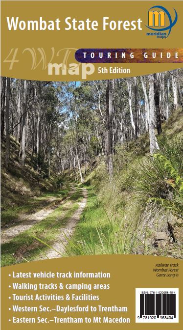
Wombat State Forest 4WD Meridian Map
$14.95
Afterpay is only available for orders between $50.00 and $1000.00 More info
Explore the rugged tracks and hidden gems of Wombat State Forest with confidence and clarity.
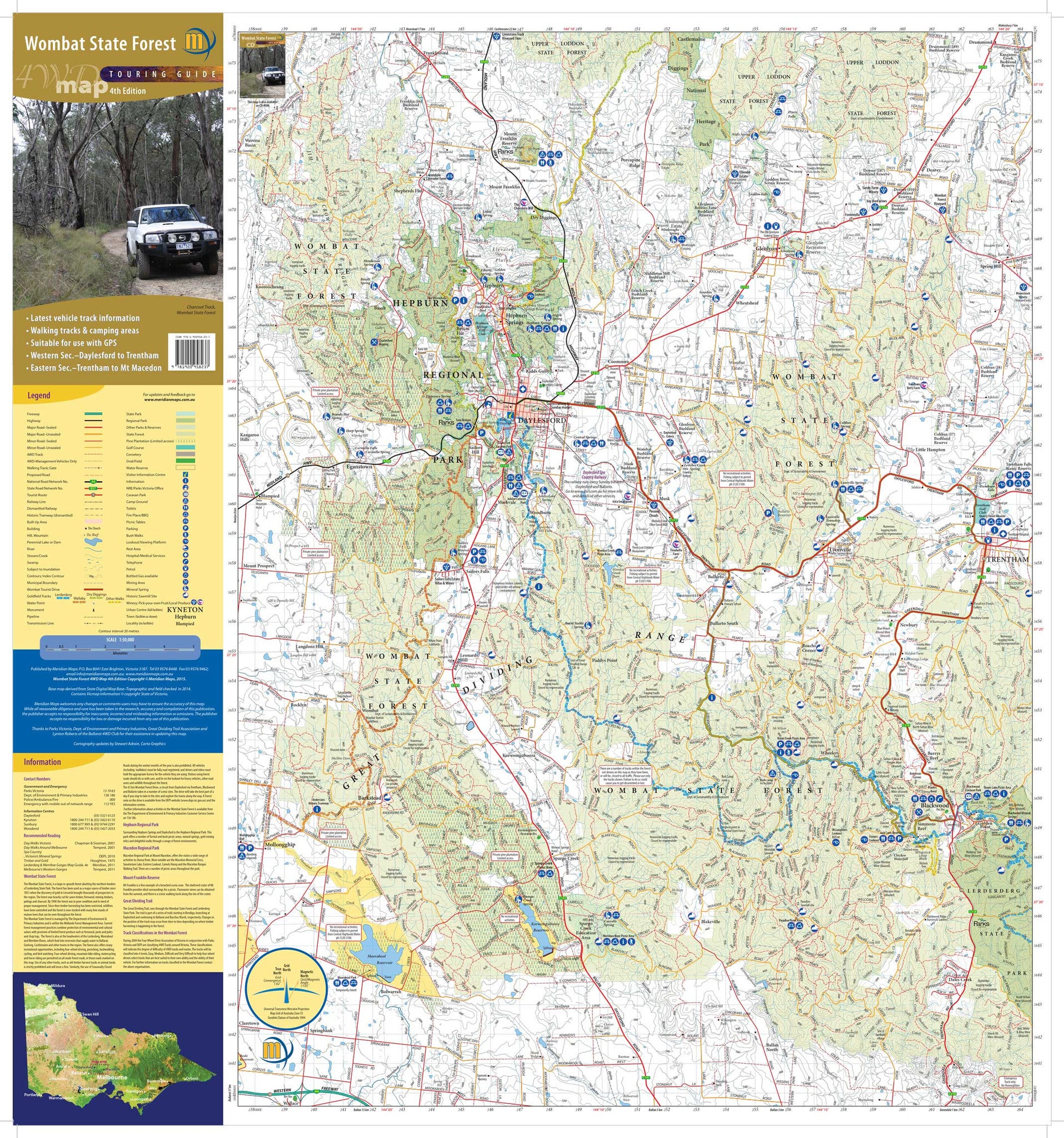
Whether you're planning a weekend off-road adventure, a day hike among towering eucalypts, or a quiet night under the stars, the Wombat State Forest 4WD Map by Meridian Maps is your indispensable companion. This highly detailed topographic and 4WD touring map is specifically designed for outdoor explorers navigating Victoria's iconic Wombat Forest region—just an hour northwest of Melbourne.
🛻 Built for 4WD Adventures
This map is more than just a folded guide—it’s a purpose-built tool for recreational 4WD drivers, campers, trail walkers, and nature lovers. The map clearly marks official 4WD tracks, walking trails, campgrounds, and natural features, making it ideal for both route planning and real-time navigation.
Key towns and landmarks include:
-
Daylesford
-
Woodend
-
Blackwood
-
Gisborne
-
Macedon
-
Trentham
-
Mount Macedon
-
Lerderderg Gorge (southern extent)
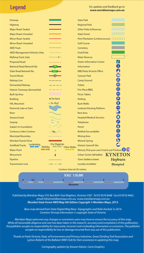
🗺️ Key Features
✅ 4WD Tracks & Difficulty Ratings
Accurate representations of official 4WD tracks with notations on access, terrain type, and driving difficulty—perfect for beginners and seasoned off-roaders alike.
✅ Topographic Base Map
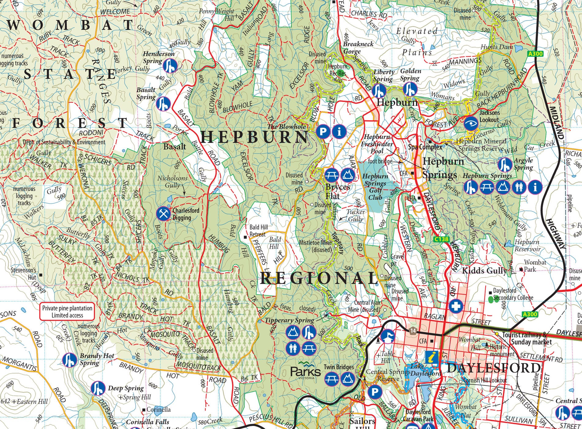
Clear contour lines and relief shading help visualise elevation, slopes, and ridge lines. Great for hikers and MTB riders who need to understand the lay of the land.
✅ Walking & Horse-Riding Trails
Includes major trail networks and shared-use paths, including segments of the Great Dividing Trail and local bushwalking tracks.
✅ Camping & Picnic Areas
All marked campsites, fireplaces, water points, and shelters are identified—making it easier to plan overnight stays or day trips.
✅ Natural & Heritage Features
The map shows waterfalls, lookouts, historic sites, mineral springs, and scenic drives—many of which are off the beaten track.
✅ Grid Referencing & GPS Compatibility
Fully GPS-referenced with UTM grid lines, making it compatible with GPS units, digital mapping tools, and field navigation systems.
✅ Fire Management Zones & Access Points
Relevant for emergency planning, seasonal closures, and safe park access during bushfire season.
🌲 About Wombat State Forest
Spanning over 70,000 hectares, the Wombat State Forest is a richly biodiverse landscape of temperate woodland, granite outcrops, fern gullies, and historic goldfields. Popular with bushwalkers, 4WD enthusiasts, and weekend campers, it offers easy access from Melbourne and forms part of the broader Macedon Ranges region.
📐 Map Specifications
| Specification | Details |
|---|---|
| Publisher | Meridian Maps |
| Edition | Latest edition (check cover for year) |
| Map Scale | 1:50,000 |
| Map Size (unfolded) | 1000 mm × 700 mm approx. |
| Folded Size | 140 mm × 250 mm approx. |
| Coverage | Wombat State Forest and surrounding towns |
| Material | Durable paper (water-resistant options may vary) |
| GPS Compatibility | Fully GPS-referenced with UTM grid |
| Relief | Topographic shading with contour lines |
| ISBN | 9781920958349 (subject to edition) |
🧭 Perfect For:
-
4WD & off-road touring
-
Bushwalking & hiking
-
Horse riding & trail running
-
Camping & caravanning
-
Local tourism, goldfield exploration, or outdoor education
-
Fire management, safety, and fieldwork in the region
🛒 Availability
-
✅ In stock – ships within 1–2 business days
-
📦 Available individually or as part of Victoria 4WD Map Packs
-
🌏 Shipping available Australia-wide and internationally
🎁 Ideal For:
-
Weekend explorers heading into the Victorian bush
-
Travellers planning routes through Lerderderg and Macedon
-
Outdoor enthusiasts looking for a reliable, hard-copy map
-
Gift-givers shopping for adventurers, 4WDers, or map lovers
Don’t rely on patchy reception or guesswork. Trust the accuracy, readability, and field-tested durability of Meridian’s Wombat State Forest Map—and head off the grid with confidence.
🧴 Optional Lamination for Enhanced Durability
We offer this map with the option of professional lamination, providing both protection and versatility. Lamination offers several key benefits:
-
✅ Write-on/wipe-off functionality – Use whiteboard markers to plan routes, mark points of interest, or highlight specific tracks, then simply wipe clean.
-
✅ Apply and remove map dots – Perfect for tracking visited locations or planning trips without damaging the surface.
-
✅ Exceptional durability – The laminated surface resists tearing, creasing, moisture, and stains, making it ideal for field use, 4WD dashboards, classrooms, or shared spaces.
-
✅ Long-lasting clarity – The lamination preserves the vibrancy and sharpness of the map for years to come.
Whether you're using this map for travel, education, or display, lamination transforms it into a robust, reusable tool that’s built to go wherever your adventure takes you.
Frequently Asked Questions
What does the Wombat State Forest 4WD Meridian Map cover?
The Wombat State Forest 4WD Meridian Map covers 4WD tracks, camping areas, and travel routes for the region described in the product title. Most 4WD and camping guides in Mapworld's range include GPS coordinates, distance information, difficulty ratings, and notes on fuel stops and emergency contact points.
Is the Wombat State Forest 4WD Meridian Map up to date?
Yes, this is the current edition. Mapworld stocks current editions from publishers including Hema Maps, Westprint, and others.
Is this product suitable for remote area travel?
Yes, 4WD maps and guides are designed for remote area navigation and trip planning. They include track conditions, fuel availability, camping spots, and safety information.
Does Mapworld ship the Wombat State Forest 4WD Meridian Map across Australia?
Yes, Mapworld ships Australia-wide. Standard shipping is a flat $7 rate, with free standard shipping on orders over $75. Express options are available at checkout. Most orders placed before 2pm AEST on weekdays are dispatched same day.
Related Items


© 2026 Mapworld. Website designed by Genie Media
X