- Australia ▾
- Topographic
▾
- Australia AUSTopo 250k (2024)
- Australia 50k Geoscience maps
- Australia 100k Geoscience maps
- Australia 250k Geoscience maps
- Australia 1.1m Geoscience maps
- New Zealand 50k maps
- New Zealand 250k maps
- New South Wales 25k maps
- New South Wales 50k maps
- New South Wales 100k maps
- Queensland 10k maps
- Queensland 25k maps
- Queensland 50k maps
- Queensland 100k maps
- Compasses
- Software
- GPS Systems
- Orienteering
- International ▾
- Wall Maps
▾
- World
- Australia & New Zealand
- Countries, Continents & Regions
- Historical
- Vintage National Geographic
- Australian Capital Territory
- New South Wales
- Northern Territory
- Queensland
- South Australia
- Tasmania
- Victoria
- Western Australia
- Celestial
- Children's
- Mining & Resources
- Wine Maps
- Healthcare
- Postcode Maps
- Electoral Maps
- Nautical ▾
- Flags
▾
- Australian Flag Sets & Banners
- Flag Bunting
- Handwavers
- Australian National Flags
- Aboriginal Flags
- Torres Strait Islander Flags
- International Flags
- Flagpoles & Accessories
- Australian Capital Territory Flags
- New South Wales Flags
- Northern Territory Flags
- Queensland Flags
- South Australia Flags
- Tasmania Flags
- Victoria Flags
- Western Australia Flags
- Gifts ▾
- Globes ▾
Dear valued customer. Please note that our checkout is not supported by old browsers. Please use a recent browser to access all checkout capabilities


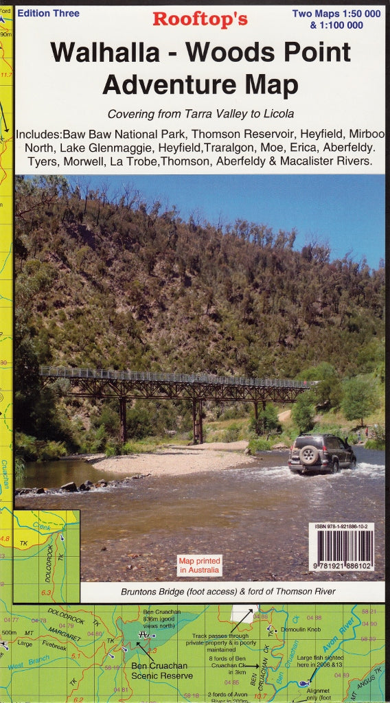
Walhalla - Woods Point Adventure Map Rooftop
$13.95
Afterpay is only available for orders between $50.00 and $1000.00 More info
Double-Sided Topographic Map | GPS-Mapped Tracks | Ideal for 4WD Touring, Bushwalking & Backcountry Adventure
The Walhalla – Woods Point Adventure Map by Rooftop Maps is your passport to the untamed beauty of Victoria’s remote alpine and forest regions. Now in its third edition, this meticulously updated map is double-sided, field-tested, and GPS-accurate, making it an essential tool for adventurers, four-wheel drivers, and anyone seeking to explore the rugged wilderness of eastern Victoria.
Whether you're navigating the historic Aberfeldy Track, hiking the forests of Baw Baw National Park, or following in the footsteps of early goldfield settlers, this map will guide you with confidence, clarity, and exceptional detail.
🧭 Key Features at a Glance
✅ Double-sided map with two levels of detail
✅ 1:100,000 topographic overview on the front side
✅ 1:50,000 forest activity enlargement on the reverse
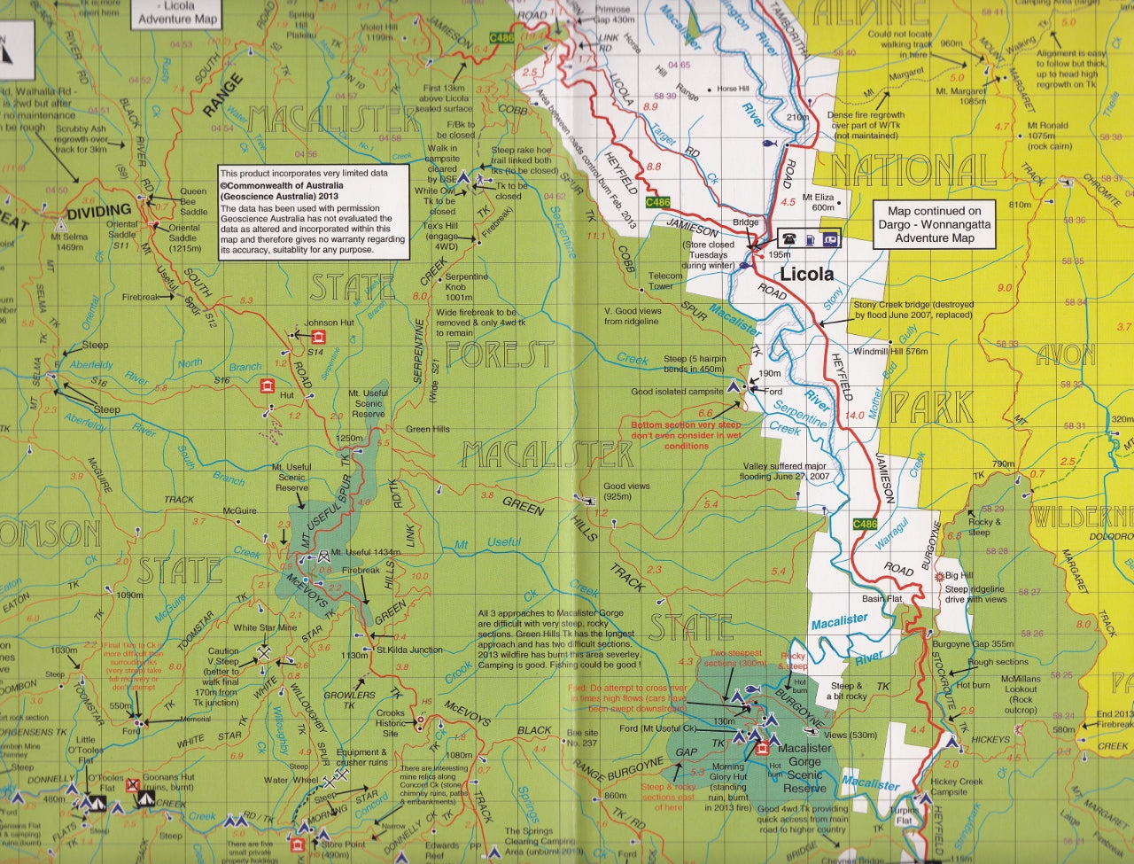
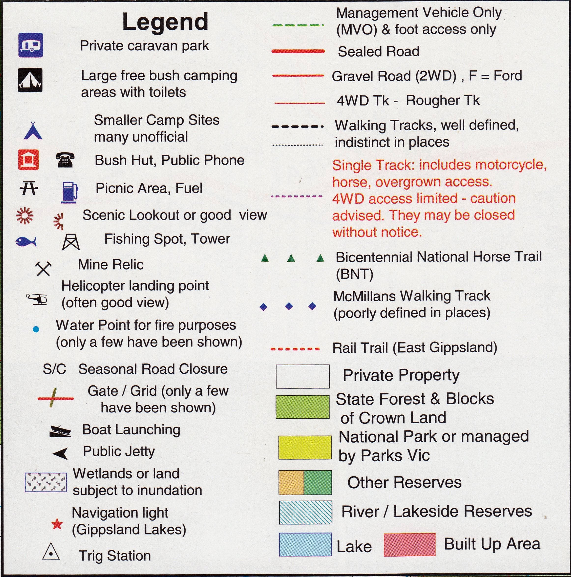
✅ Contours, watercourses, roads, tracks, huts & campsites clearly marked
✅ Covers key national parks, towns, trails and wilderness areas
✅ Researched and plotted using high-precision GPS data
✅ Laminated option available for weatherproof and reusable navigation
🗺️ Coverage Area
This edition spans an extensive area from the coastal foothills of the Tarra Valley in the south to the mountain trails of Licola in the north. Included in the coverage are:
-
Baw Baw National Park
-
Tarra-Bulga National Park
-
Thomson Dam & Reservoir
-
Lake Glenmaggie & Macalister River Region
-
Gold mining towns: Walhalla, Woods Point, Aberfeldy
-
Nearby towns: Heyfield, Moe, Traralgon, Erica, Mirboo North, Tyers, Morwell, Blackwarry, and Won Wron
Every road, fire trail, 4WD track, walking route, and river crossing has been meticulously mapped, making this one of the most accurate and user-friendly maps available for this region.
📐 Map Specifications
| Feature | Detail |
|---|---|
| Publisher | Rooftop Maps (Australia) |
| Edition | 3rd |
| Map Type | Topographic & Forest Activities Map |
| Scale (Front) | 1:100,000 – broad regional coverage |
| Scale (Reverse) | 1:50,000 – detailed focus on the Walhalla-Woods Point area |
| Size | 700 mm (W) × 1000 mm (H) |
| Data Source | Field-verified with GPS technology |
| Format Options | Folded or flat laminated |
🛠️ What's On the Map?
-
🛤️ All Public & 4WD Roads – with surface type, access, and gate indicators
-
🥾 Walking & Hiking Tracks – both short walks and multiday options
-
🏕️ Campgrounds & Bush Campsites – including access notes and facilities
-
🛖 Bush Huts – historic and functional, ideal for overnight stays
-
💧 Rivers, Streams & Lakes – including seasonal flow data and crossings
-
🌲 State Forests, National Parks & Reserves – with clear boundaries
-
⚠️ Hazards & Track Warnings – notes on steep terrain, closures, and 4WD difficulty
-
🧭 Latitude/Longitude Grid – suitable for use with GPS devices and compasses
🧱 Laminated Option Available
Want more durability for the outdoors? Upgrade to our flat laminated version:
-
💧 Waterproof and tear-resistant
-
✏️ Writeable with whiteboard markers – ideal for route planning or marking campsites
-
🔄 Reusable for multiple trips
-
📦 Shipped rolled in a protective map tube – arrives ready to use, not creased
🎒 Who Is This Map For?
| User | Why They Love It |
|---|---|
| 🚙 4WD & Touring Enthusiasts | Navigate remote roads, assess terrain, and plan camp stops |
| 🥾 Bushwalkers & Trail Runners | Discover hiking routes and emergency access points |
| 🏕️ Campers & Nature Lovers | Find off-grid camping areas and scenic overnight spots |
| 🚒 Emergency Services | Use for remote area planning, fire trails and access control |
| 📸 Photographers & Birders | Scout lesser-known lookouts and natural features |
| 🎓 Students & Researchers | Study topography, land use, and environmental features |
🌄 Explore the Alpine Heart of Victoria
Rooftop’s Walhalla – Woods Point Adventure Map opens up one of Victoria’s most storied and stunning wilderness regions. From rainforest-covered ranges to gold rush relics, river valleys to alpine plains, this map lets you chart your own course through terrain few others reach.
Whether you're discovering the ruins of an old mining settlement or pitching a tent beneath a sky full of stars, this map ensures you’re informed, equipped, and inspired—wherever the track leads.
Ready to Roam
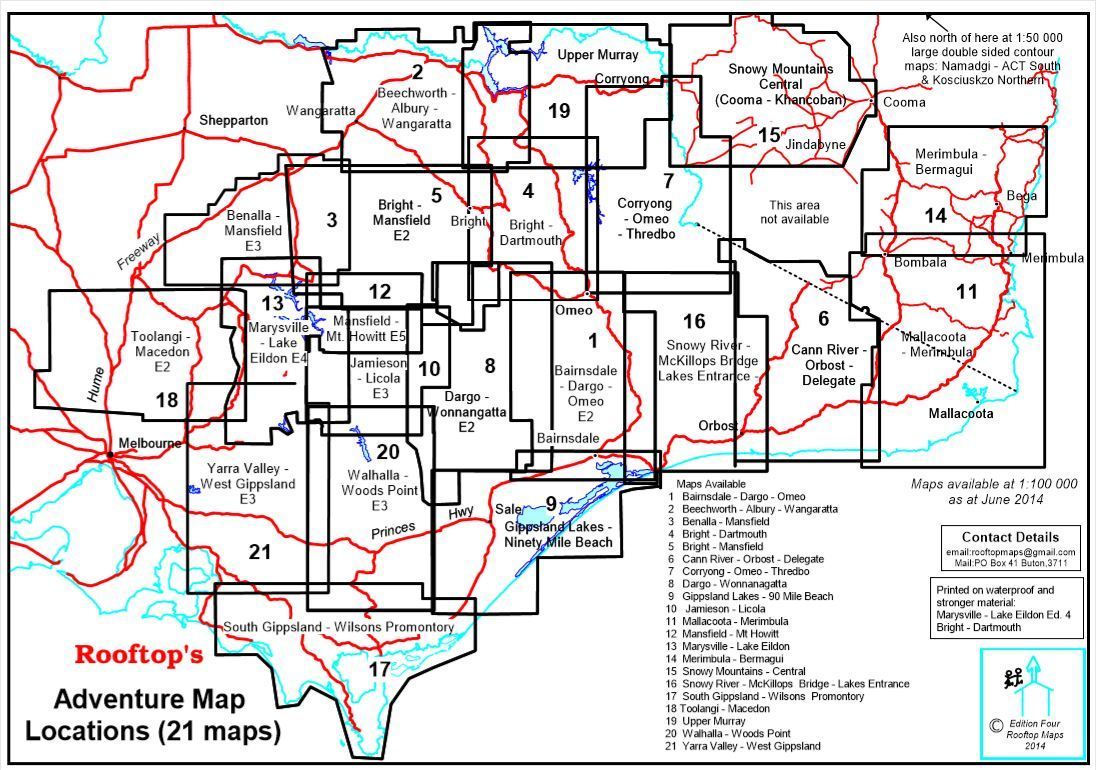
Start planning your next escape into Victoria’s high country with Rooftop’s trusted cartography. Want even more coverage? Pair it with the Jamieson–Licola Adventure Map or our full Rooftop Map bundle for the ultimate alpine explorer’s kit.


