- Australia ▾
- Topographic
▾
- Australia AUSTopo 250k (2024)
- Australia 50k Geoscience maps
- Australia 100k Geoscience maps
- Australia 250k Geoscience maps
- Australia 1.1m Geoscience maps
- New Zealand 50k maps
- New Zealand 250k maps
- New South Wales 25k maps
- New South Wales 50k maps
- New South Wales 100k maps
- Queensland 10k maps
- Queensland 25k maps
- Queensland 50k maps
- Queensland 100k maps
- Compasses
- Software
- GPS Systems
- Orienteering
- International ▾
- Wall Maps
▾
- World
- Australia & New Zealand
- Countries, Continents & Regions
- Historical
- Vintage National Geographic
- Australian Capital Territory
- New South Wales
- Northern Territory
- Queensland
- South Australia
- Tasmania
- Victoria
- Western Australia
- Celestial
- Children's
- Mining & Resources
- Wine Maps
- Healthcare
- Postcode Maps
- Electoral Maps
- Nautical ▾
- Flags
▾
- Australian Flag Sets & Banners
- Flag Bunting
- Handwavers
- Australian National Flags
- Aboriginal Flags
- Torres Strait Islander Flags
- International Flags
- Flagpoles & Accessories
- Australian Capital Territory Flags
- New South Wales Flags
- Northern Territory Flags
- Queensland Flags
- South Australia Flags
- Tasmania Flags
- Victoria Flags
- Western Australia Flags
- Gifts ▾
- Globes ▾
Dear valued customer. Please note that our checkout is not supported by old browsers. Please use a recent browser to access all checkout capabilities
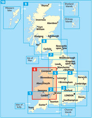
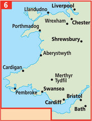
Wales AA Road Map 6
$19.95
Afterpay is only available for orders between $50.00 and $1000.00 More info
Folded Road Map by the Automobile Association (AA)
Scale: 1:250,000 | Size: 1200 mm x 980 mm | Format: Folded Paper
Whether you’re navigating the dramatic cliffs of Pembrokeshire, weaving through the misty valleys of Snowdonia, or heading for a long weekend in Cardiff, the AA Road Map of Wales is your ultimate glovebox companion. Produced by Britain’s most trusted motoring authority, this detailed, user-friendly map is designed to guide you through every bend, detour, and hidden gem the country has to offer.
🛣️ Mapping You Can Trust
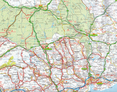
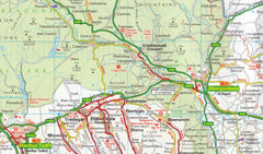
With a generous scale of 1:250,000 (4 miles to 1 inch), this easy-to-read map provides clarity and precision for both long-distance travel and local detours. The cartography is crisp, the colour palette intuitive, and the symbols clearly defined—whether you're on a major motorway or a narrow country lane.
The map includes the most up-to-date road information available, with:
-
Motorways and dual carriageways clearly distinguished
-
Road numbers for quick navigation
-
Toll points and service areas shown for strategic pitstops
-
Minor roads and lanes included for scenic or rural travel
-
Speed camera locations, with many displaying the actual speed limit
🏕️ Touring Essentials at a Glance
This map is more than just roads—it’s an all-in-one touring tool. Points of interest, natural landmarks, and visitor facilities are flagged throughout the map for effortless holiday planning. Whether you’re chasing waterfalls or plotting pub lunches, you’ll appreciate:
-
Caravan and camping sites pinpointed on the map
-
National Parks and designated scenic routes
-
Tourist attractions such as castles, gardens, and museums
-
National Trust, English Heritage, and Welsh Heritage properties all clearly marked
🏙️ Urban Navigation Made Simple
To help you navigate built-up areas and plan urban outings, the map includes detailed city and town centre insets, each highlighting road networks, key landmarks, and major transport links. Included city plans:
-
Cardiff
-
Swansea
-
Aberystwyth
-
Liverpool
-
Chester
-
Shrewsbury
-
Llandudno
-
Bristol
These maps are ideal for locating parking areas, public transport hubs, and central attractions.
📚 Comprehensive Indexing & Reference Tools
Finding your destination is fast and straightforward thanks to a full place-name index, printed in a large, readable font and easy to navigate. Whether you're headed to a well-known city or a quiet village, this index will get you there without fuss.
💡 Added Features
-
Encased in a weatherproof protective sleeve for durability on the road
-
Compact and easy to fold—perfect for storing in your glovebox, backpack, or map pocket
-
Includes symbol keys and road legend in multiple languages for international travellers
-
Designed to work alongside sat-navs or GPS as a trusted offline backup
🧭 Who This Map is For:
-
Holidaymakers exploring by car or caravan
-
Business travellers needing a reliable planning tool
-
Delivery drivers and couriers working across Wales
-
Outdoor adventurers seeking the lay of the land
-
Locals and expats reconnecting with the regions
Whether you’re a seasoned traveller or visiting for the first time, the AA’s Wales Road Map is a smart, affordable investment in smooth, informed, and enjoyable travel.
🗂️ Specifications:
-
Scale: 1:250,000 (4 miles to 1 inch / 2.5 km to 1 cm)
-
Size (unfolded): 1200 mm x 980 mm
-
Format: Folded paper map
-
Publisher: The AA (Automobile Association)
-
Publication Year: Latest available edition
🧳 Travel smart. Stay on course. Discover Wales the way it was meant to be seen—on the road.


