Charting a Continent — The Voyages of Matthew Flinders (1798–1803)
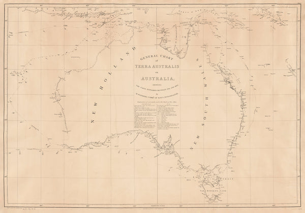
Follow the wake-lines that named a coastline. This meticulously reproduced wall map chronicles Matthew Flinders’ voyages between 1798 and 1803, culminating in his command of HMS Investigator and the first circumnavigation that defined Australia as a continent. Issued in London by G. & W. Nicol (January 1814), the original engraving gathers routes, landfalls, and coastal observations into a single, gripping narrative of seamanship and discovery—an atlas page where a nation’s outline comes into focus.
More Than a Map – A Testament to History
This isn’t just wall art—it’s the documentary thread of an age of exploration. Each plotted track, coastal note, and engraved place name reveals the discipline and daring behind Flinders’ surveys. For maritime history enthusiasts, educators, collectors, and families with ties to Australia’s coastal story, it’s both a visual treasure and a richly instructive primary source.
Display it in classrooms, offices, museums, libraries, or your home to invite reflection, study, and conversation.
Premium Materials & Finishes
We treat history with the respect it deserves. That’s why we offer multiple formats, each produced using the highest quality materials and modern archival printing techniques.
🌟 Archival Paper Print
Printed on heavyweight 160gsm archival-grade paper.
A smooth matte finish reduces glare and highlights every finely engraved course line and coastal label.
Ideal for framing under glass—classic, refined, and built to last.
💎 Laminated Edition
Encapsulated in two 80-micron gloss laminate sheets using true thermal bonding (not just surface film).
Moisture-resistant, wipe-clean durability—perfect for classrooms, offices, and high-traffic spaces.
Optional Natural Timber Hang Rails: lacquered rails with a fitted hanging cord create a polished, ready-to-display presentation—no frame required. (Please allow up to 10 working days for delivery with hang rails.)
🏆 Museum-Quality Canvas
Printed on 395gsm HP Professional Matte Canvas for rich texture and strength.
Pigment-based, fade-resistant inks deliver deep tone and crisp linework that endure for generations.
Optional Natural Timber Hang Rails: lacquered to enhance the grain, with a top cord for effortless hanging—timeless and elegant. (Please allow up to 10 working days for delivery with hang rails.)
Specifications
| Feature | Details |
|---|---|
| Original Publication | January 1814, G. & W. Nicol, Pall Mall (London) |
| Explorer/Source | Matthew Flinders (voyage tracks 1798–1803) |
| Vessel (principal survey) | HMS Investigator (1801–1803) |
| Title | Voyages of Matthew Flinders — 1798 to 1803 |
| Map Size | 920 mm (W) × 640 mm (H) |
| Available Formats | Paper, Laminated, Canvas |
| Paper Weight | 160gsm archival-quality |
| Laminate | 2 × 80-micron gloss sheets (encapsulated) |
| Canvas Weight | 395gsm HP Professional Matte Canvas |
| Inks | Pigment-based, fade-resistant |
| Optional Hang Rails | Available on Laminated & Canvas versions |
| Origin | Made in Australia |
Why Choose This Map
✔ A Defining Narrative: Trace Flinders’ consolidated voyages (1798–1803) that confirmed Australia’s continental form.
✔ Clear Route Storytelling: Legible tracks and landfalls turn complex expeditions into an at-a-glance chronology.
✔ Decorative & Scholarly: Period engraving balances display impact with research value.
✔ Crafted to Endure: Premium substrates and archival inks keep colour and linework true for decades.
✔ Ready to Display: Choose hang-railed laminated or canvas editions for a museum-quality presentation—no frame needed.
✔ A Meaningful Gift: Perfect for sailors, historians, educators, and anyone inspired by discovery.
Our Commitment
We believe preserving history is as important as telling it. Every map is printed locally in Australia using state-of-the-art technology, carefully checked by hand, and packed with care. From our workshop to your wall, we ensure quality you can trust and a legacy you’ll be proud to share.
Bring the age of discovery into your space with a faithful, beautifully produced chart. Order the Voyages of Matthew Flinders (1798–1803) Wall Map today—a tribute to courage, careful observation, and the coastline that became a country.


