

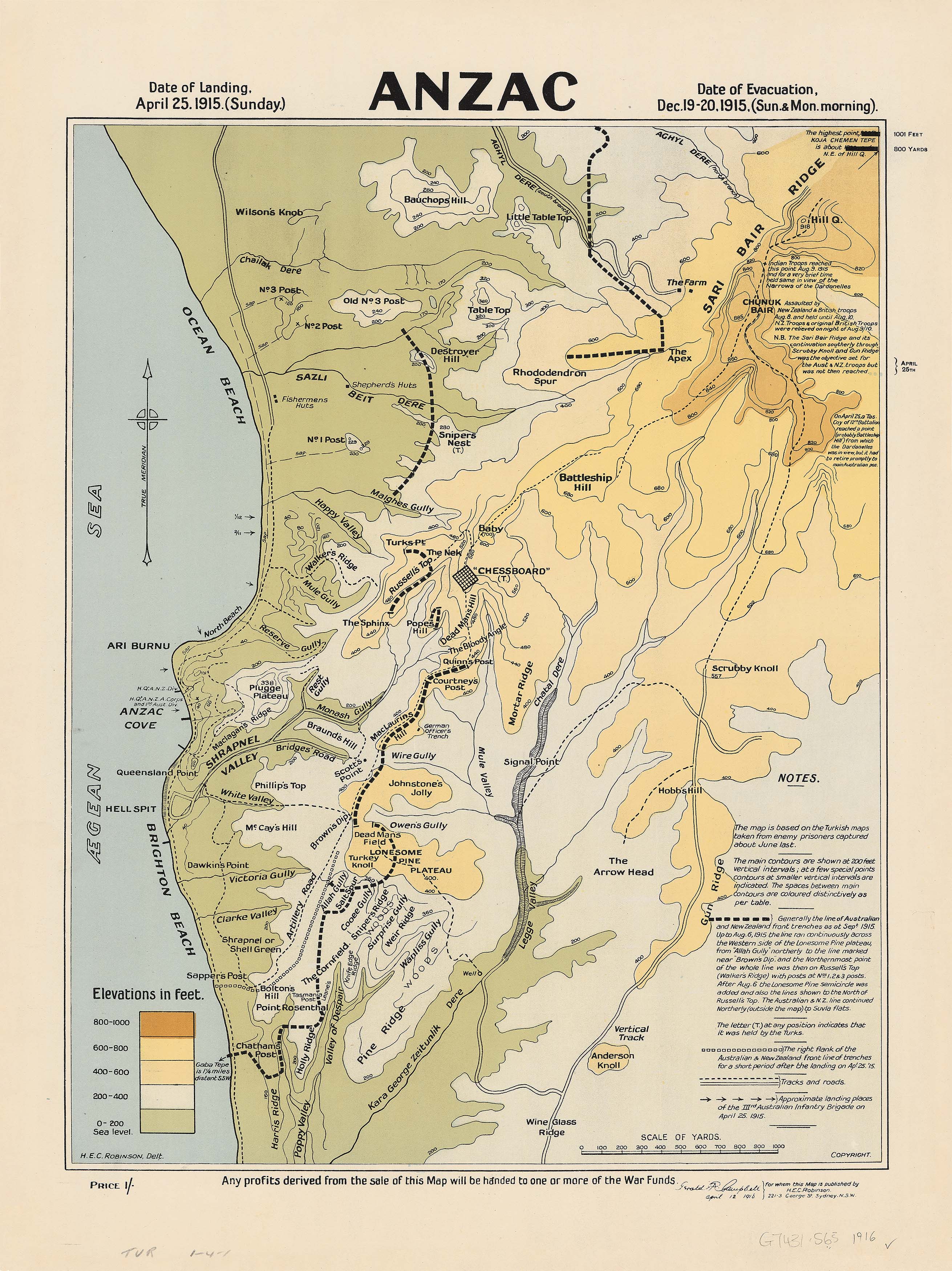
ANZAC Wall Map (1916) — H.E.C. Robinson
An extraordinary First World War artefact, faithfully reproduced for premium display
Why this map matters
-
🗺️ Published in 1916, during the war itself — a contemporaneous record of Gallipoli as Australians understood it then.
-
⚔️ A visual narrative of the campaign — from the dawn landing on 25 April 1915 to the final evacuations in January 1916.
-
🧭 Military-grade detail — trenches, Allied and Ottoman positions, terrain, and sea-to-elevation gradients rendered with Robinson’s trademark clarity.
-
🏛️ Collectible heritage — a powerful centrepiece for homes, schools, RSLs, museums, and anyone honouring the legacy of ANZAC.
What you’ll see
-
Complete campaign timeline: landing to evacuation.
-
Trench systems (as at Sept 1915) clearly delineated.
-
Topographic shading from sea level to 1,000+ ft, revealing ridgelines, gullies, and choke points.
-
Annotated positions & notes identifying key advances, defences, and terrain obstacles.
-
H.E.C. Robinson studio craft: clean typography, disciplined linework, and legible symbology.
About this edition
First issued by H.E.C. Robinson in 1916, this is a faithful reproduction of the wartime map—preserving its detail, tone, and historical voice. It is both an educational tool and an heirloom-quality print that brings context and gravity to any setting.
Choose your finish
Paper (160 gsm, matte)
-
Ideal for professional framing under glass
-
Crisp linework and superb text clarity
Laminated (true encapsulation)
-
Twin 80-micron gloss sheets, sealed edge-to-edge
-
Wipeable, durable, stain-resistant — perfect for classrooms and shared spaces
Canvas (395 gsm HP Professional Matte)
-
Pigment-based, fade-resistant inks for archival longevity
-
Rich, textured surface with museum-quality presence
-
Optional timber hang rails available
Optional timber hang rails (Laminated & Canvas)
-
Natural lacquered timber rails (top & bottom) with a discreet hanging cord
-
Enhances the period character; ready to hang — just add a wall hook
-
Lead time: please allow up to 10 working days for hang-railed maps, custom-finished by our professional framer
Sizes & scale
| Variant | Size (W × H) | Scale | Finishes |
|---|---|---|---|
| Large | 630 × 840 mm | Not specified | Paper, Laminated, Canvas |
| Supermap | 970 × 1300 mm | Not specified | Paper, Laminated, Canvas |
Material options (at a glance)
| Finish | Description |
|---|---|
| Paper (160 gsm) | Heavyweight matte stock for sharp lines and elegant, frame-ready presentation. |
| Laminated | True gloss encapsulation (80-micron each side); wipe-clean, tough, and classroom-friendly. |
| Canvas (395 gsm) | Archival HP Matte Canvas with pigment inks for long-lasting, gallery-grade depth and clarity. |
Specifications
| Detail | Description |
|---|---|
| Title | ANZAC Wall Map |
| Original Publication | 1916 |
| Cartographer/Publisher | H.E.C. Robinson (Sydney) |
| Campaign Coverage | Gallipoli, April 1915 – January 1916 |
| Content | Trench systems (Sept 1915), Allied & Ottoman positions, topographic shading, annotations |
| Reproduction | Faithful premium edition for framing, study, or display |
| Finishes | Paper, Laminated (encapsulated), Canvas (archival) |
| Hanging | Optional timber rails for Laminated & Canvas (lead time applies) |
| Made | Proudly made in Australia |
Ideal for
-
RSLs, schools, and museums seeking a compelling teaching or commemorative piece
-
Historians, collectors, and descendants engaging deeply with ANZAC history
-
Designers & curators creating dignified heritage interiors and public spaces
This is more than a map—it is a living document of courage and country, rendered with the precision of H.E.C. Robinson and reproduced to the highest modern standards.


