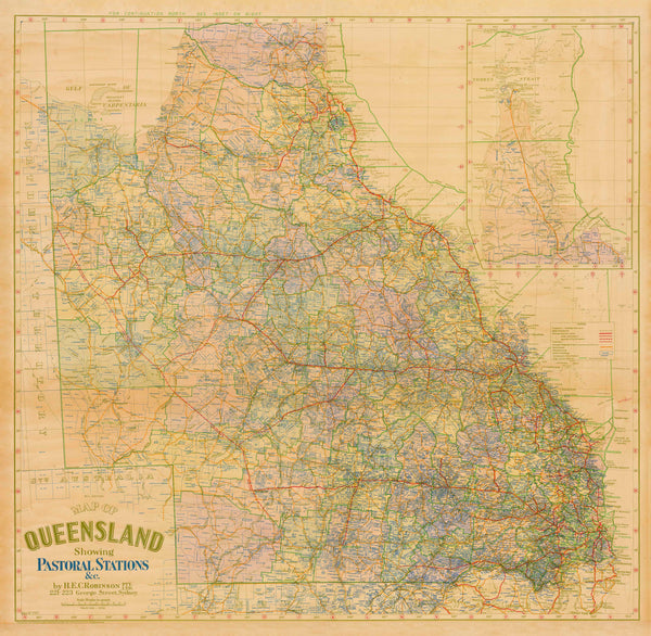
Queensland Pastoral Stations (1920) — H.E.C. Robinson
An heirloom-quality heritage map capturing the pastoral backbone of Queensland
The feeling it brings
-
🐑 A living record of Country — stations, families, and runs that defined Queensland at the close of WWI.
-
🖋️ Robinson’s studio craft — elegant typography, disciplined linework, and balanced tones that turn reference into art.
-
🏛️ History you can point to — a credible tool for genealogists, historians, educators, and collectors of Australiana.
Heritage context
Originally compiled by H.E.C. Robinson, Australia’s pre-eminent map publisher of the era, this 1920 wall map captures a rare, comprehensive snapshot of Queensland’s rural economy in the late 1910s. Pastoralism was the engine of settlement and export; this edition shows how stations and regional divisions stretched from the Gulf Country and Cape York down through the Central Highlands, Darling Downs, and the Channel Country—a state-wide tapestry of land tenure and enterprise.
What you’ll see
-
Major pastoral holdings & station names across the breadth of Queensland (c. 1918 context)
-
Regional and administrative divisions as recognised at the time
-
Readable settlement patterns that illuminate land use, wool and livestock corridors, and inland–coastal relationships
-
Period styling preserved: clear lettering, fine boundary work, and Robinson’s lucid layout
Cartographic pedigree
H.E.C. Robinson’s Sydney studio set the benchmark for clarity and authority in early 20th-century mapping. This faithful reproduction honours the original’s composition and detail while delivering contemporary print precision—equally at home in a study, gallery wall, museum, or research room.
Choose your finish
Paper (160 gsm matte)
-
Frame-under-glass ready
-
Smooth, non-glare surface for superb legibility
-
Preserves fine boundary work and smaller station labels
Laminated (true encapsulation)
-
Sealed between two 80-micron gloss sheets, edge-to-edge
-
Wipe-clean, moisture-resistant, hard-wearing
-
Ideal for classrooms, libraries, offices, and high-traffic displays
Canvas (395 gsm HP Professional Matte)
-
Pigment-based, fade-resistant inks for archival longevity
-
Subtle texture adds warmth and gallery presence
-
A statement piece for homes, boardrooms, heritage venues, and public foyers
Optional timber hang rails (Canvas)
-
Natural lacquered timber rails (top & bottom) with discreet hanging cord
-
Clean, gallery-style presentation—just add a wall hook
-
Lead time: please allow up to 10 working days for hang-railed canvases (custom mounted by our professional framer)
Sizes (W × H) — room fit
-
Standard — 1000 × 976 mm
Perfect above a console or desk; intimate detail without overpowering a room. -
Large — 1200 × 1164 mm
Commanding feature for living rooms, libraries, boardrooms, or long hallways.
Who it’s for
-
Station families & descendants tracing pastoral lineage
-
Historians & educators building Queensland studies collections
-
Museums & libraries curating rural and economic heritage displays
-
Designers & curators seeking authentic period character with narrative depth
At-a-glance materials
| Finish | Best for | Key benefits |
|---|---|---|
| Paper (160 gsm) | Framing under glass | Matte clarity, crisp lines, classic presentation |
| Laminated (encapsulated) | Busy/shared spaces | Wipe-clean, durable, edge-to-edge protection |
| Canvas (395 gsm) | Premium display | Archival inks, textured depth, gallery appeal |
Specifications
| Detail | Description |
|---|---|
| Title | Queensland Pastoral Stations |
| Original Publication | 1920 |
| Cartographer/Publisher | H.E.C. Robinson (Sydney) |
| Coverage | Pastoral stations, holdings, and regional divisions across Queensland (c. 1918 context) |
| Map Type | Historical pastoral / economic heritage |
| Orientation | Landscape |
| Language | English |
| Finishes | Paper, Laminated (encapsulated), Canvas (archival) |
| Hanging | Optional timber rails for Canvas (lead time applies) |
| Sizes | Standard 1000 × 976 mm; Large 1200 × 1164 mm |
| Reproduction | Premium archival edition, produced in Australia |
Why choose this edition
-
Faithful to the period — preserves Robinson’s linework, lettering, and composition
-
Decor-ready — refined enough for formal interiors, robust enough for public settings
-
Research-friendly — a practical reference with clear station naming and regional structure
-
Enduring value — archival materials and finishes for long-lived display
A timeless tribute to Queensland’s pastoral legacy—beautifully reproduced, deeply informative, and ready to anchor a room with story and significance.


