- Australia ▾
- Topographic
▾
- Australia AUSTopo 250k (2024)
- Australia 50k Geoscience maps
- Australia 100k Geoscience maps
- Australia 250k Geoscience maps
- Australia 1.1m Geoscience maps
- New Zealand 50k maps
- New Zealand 250k maps
- New South Wales 25k maps
- New South Wales 50k maps
- New South Wales 100k maps
- Queensland 10k maps
- Queensland 25k maps
- Queensland 50k maps
- Queensland 100k maps
- Compasses
- Software
- GPS Systems
- Orienteering
- International ▾
- Wall Maps
▾
- World
- Australia & New Zealand
- Countries, Continents & Regions
- Historical
- Vintage National Geographic
- Australian Capital Territory
- New South Wales
- Northern Territory
- Queensland
- South Australia
- Tasmania
- Victoria
- Western Australia
- Celestial
- Children's
- Mining & Resources
- Wine Maps
- Healthcare
- Postcode Maps
- Electoral Maps
- Nautical ▾
- Flags
▾
- Australian Flag Sets & Banners
- Flag Bunting
- Handwavers
- Australian National Flags
- Aboriginal Flags
- Torres Strait Islander Flags
- International Flags
- Flagpoles & Accessories
- Australian Capital Territory Flags
- New South Wales Flags
- Northern Territory Flags
- Queensland Flags
- South Australia Flags
- Tasmania Flags
- Victoria Flags
- Western Australia Flags
- Gifts ▾
- Globes ▾
Dear valued customer. Please note that our checkout is not supported by old browsers. Please use a recent browser to access all checkout capabilities


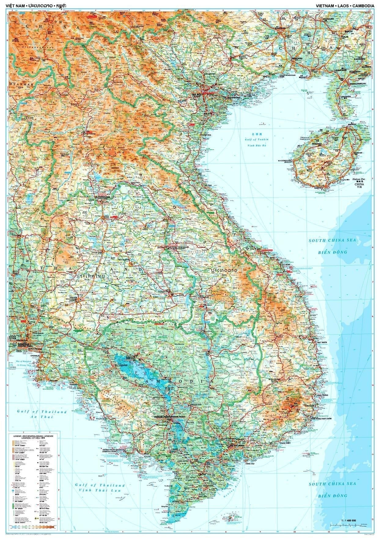
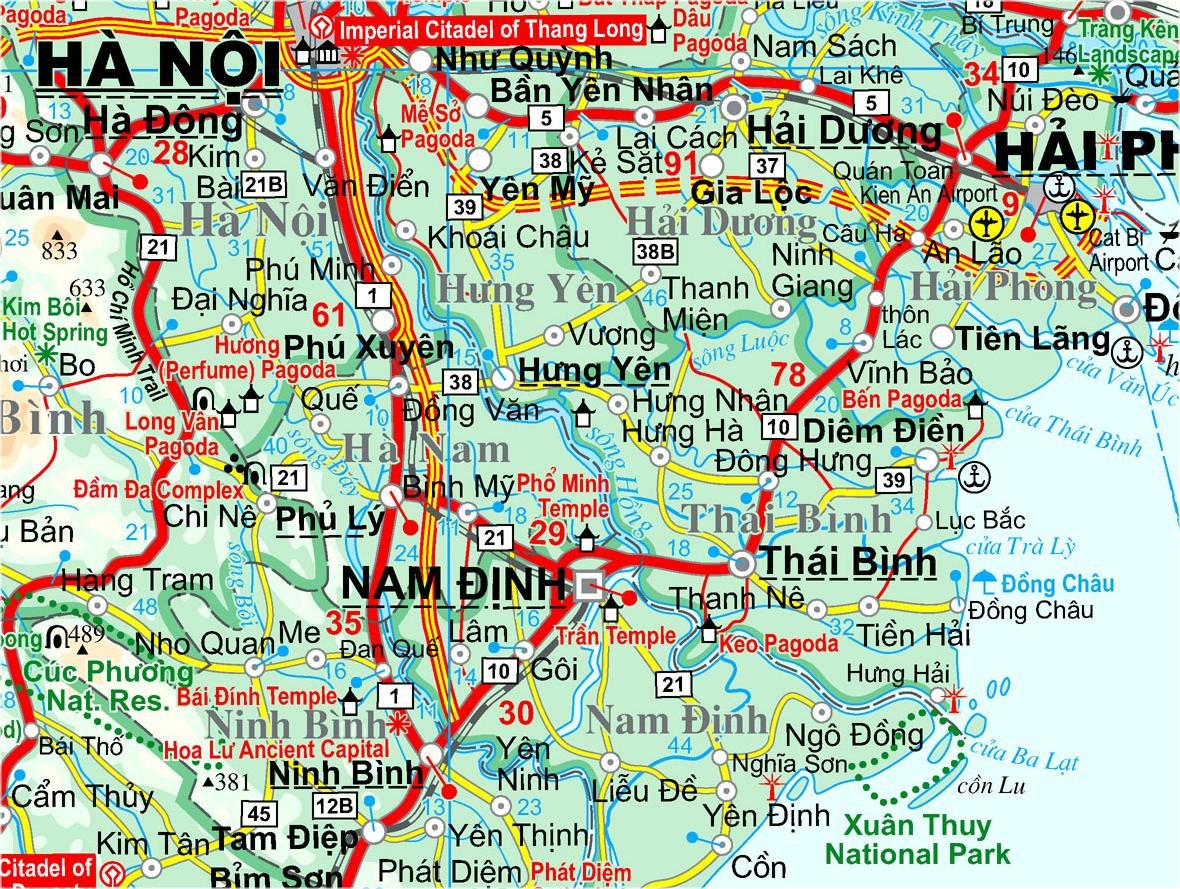
Vietnam, Laos, Cambodia Gizi Maps Folded
$24.95
Afterpay is only available for orders between $50.00 and $1000.00 More info
Single-Sided Regional Map | Scale 1:1,400,000
Detailed Cartography with Elevation Shading, Tourist Symbols & Index
Unfolded Size: 1000 mm x 930 mm
🧭 Explore the Cultural Heart of Indochina
Journey through the richly layered landscapes of Vietnam, Laos, and Cambodia with this meticulously crafted folded map by Gizi Maps. Covering three of Southeast Asia’s most culturally vibrant nations, this map delivers a complete regional overview for travellers, educators, and explorers alike.
Whether you're navigating the winding roads from Hanoi to Luang Prabang, or planning an overland adventure from Phnom Penh to Hoi An, this detailed 1:1,400,000 scale map offers practical and visually intuitive guidance for route planning, sightseeing, and cultural discovery.
🗺️ Map Features
✅ Three Countries, One Seamless Overview
-
Covers all of Vietnam, Laos, and Cambodia
-
Borders with Thailand, China, and Myanmar clearly marked
-
Cities and towns from Hanoi, Vientiane, and Phnom Penh to smaller heritage towns and villages
✅ Road Network & Travel Routes
-
Major highways, secondary roads, and local connectors clearly shown
-
Distances in kilometers along key routes
-
Ideal for planning cross-border travel, regional tours, or independent overland trips
✅ Topography & Natural Features
-
Elevation depicted through colour shading and contour tints
-
Major rivers, lakes, mountain ranges, and highlands clearly marked
-
Terrain visualization helps assess travel conditions in remote regions
✅ Tourist Symbols & Landmarks
-
🛕 Temples, pagodas, and ancient ruins
-
🏞️ National parks and biosphere reserves
-
🚉 Border crossings, ferry terminals, and airstrips
-
⛩️ UNESCO World Heritage Sites like Angkor Wat, Luang Prabang, and Phong Nha-Ke Bang
✅ Comprehensive Place Name Index
-
Includes hundreds of cities, towns, and key geographic names
-
Essential for quick reference, educational use, and itinerary planning
📐 Map Specifications
| Feature | Details |
|---|---|
| Publisher | Gizi Maps |
| Map Type | Folded, single-sided travel map |
| Scale | 1:1,400,000 |
| Sheet Size | 1000 mm x 930 mm |
| Material | High-quality paper |
| Topographic Detail | Elevation shading, spot heights, and rivers |
| Tourism Symbols | Yes – cultural sites, parks, and services |
| Place Name Index | Included |
| Language | English (legend and place names) |
| Edition | Current edition from Gizi’s Southeast Asia series |
👥 Perfect For:
-
🌏 Regional travelers exploring Indochina overland or by motorcycle
-
🎓 Students, educators, and researchers studying Southeast Asia’s geography and cultures
-
🧭 Backpackers and tour operators planning cross-border itineraries
-
🗺️ Map collectors and travel enthusiasts seeking beautiful and functional cartography
🛒 Order the Vietnam, Laos & Cambodia Gizi Folded Map Today
An essential map for navigating the cultural and geographic crossroads of Southeast Asia. Whether you're walking the streets of Luang Prabang, visiting temples in Angkor, or cruising the Mekong Delta, this map is the perfect companion.
📦 Please note: This is an order-on-demand item from the publisher. Kindly allow up to 10 working days for delivery.


