- Australia ▾
- Topographic
▾
- Australia AUSTopo 250k (2025)
- Australia 50k Geoscience maps
- Australia 100k Geoscience maps
- Australia 250k Geoscience maps
- Australia 1:1m Geoscience maps
- New Zealand 50k maps
- New Zealand 250k maps
- New South Wales 25k maps
- New South Wales 50k maps
- New South Wales 100k maps
- Queensland 10k maps
- Queensland 25k maps
- Queensland 50k maps
- Queensland 100k maps
- Western Australia 25k maps
- Western Australia 50k maps
- Western Australia 100k maps
- Compasses
- Software
- GPS Systems
- International ▾
- Wall Maps
▾
- World
- Australia & New Zealand
- Countries, Continents & Regions
- Historical
- Vintage National Geographic
- Australian Capital Territory
- New South Wales
- Northern Territory
- Queensland
- South Australia
- Tasmania
- Victoria
- Western Australia
- Celestial
- Children's
- Mining & Resources
- Wine Maps
- Healthcare
- Postcode Maps
- Electoral Maps
- Nautical ▾
- Flags
▾
- Australian Flag Sets & Banners
- Flag Bunting
- Handwavers
- Australian National Flags
- Aboriginal Flags
- Torres Strait Islander Flags
- International Flags
- Flagpoles & Accessories
- Australian Capital Territory Flags
- New South Wales Flags
- Northern Territory Flags
- Queensland Flags
- South Australia Flags
- Tasmania Flags
- Victoria Flags
- Western Australia Flags
- Gifts ▾
- Globes ▾
Dear valued customer. Please note that our checkout is not supported by old browsers. Please use a recent browser to access all checkout capabilities


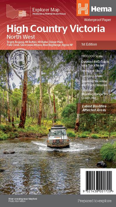
Victorian High Country NW 100K Hema Map
$14.95 $15.95
Afterpay is only available for orders between $50.00 and $1000.00 More info
Part of Hema’s New Victorian High Country Series
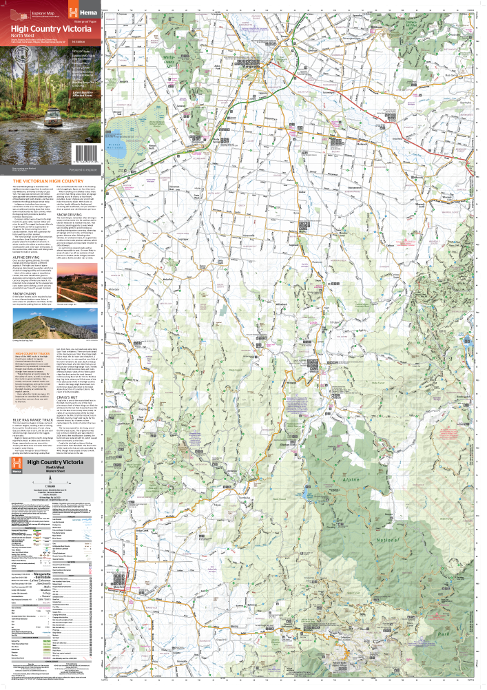
Scale: 1:100,000 | Open Size: 695 mm x 995 mm | Waterproof & Laminated Options Available
Explore Australia’s alpine frontier with confidence using the Victorian High Country – North West Map, part of Hema’s latest and most advanced topographic map series. Covering the North Western Alps, including Hotham, Wangaratta, and surrounding wilderness, this map is your ultimate companion for 4WD adventures, bush camping, and high-country touring.
✅ What Makes This Map Essential
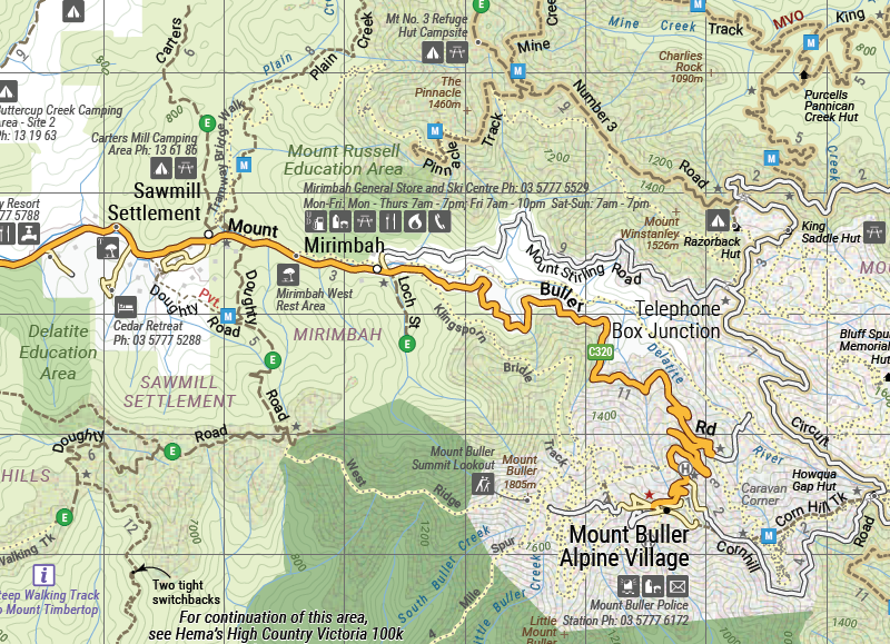
🧭 4WD-Ready with Field-Checked Tracks
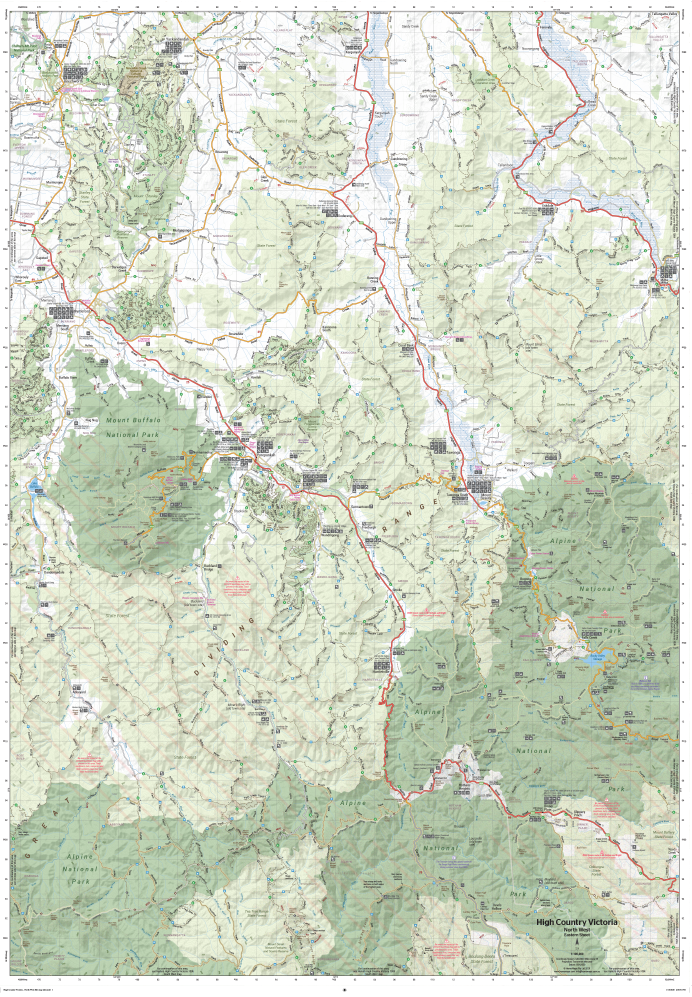
The map includes Hema’s entire database of roads and 4WD tracks, verified in the field by the legendary Hema Map Patrol. Expect up-to-date and reliable information for remote navigation, route planning, and vehicle access.
🌲 Topographic Detail Meets Touring Functionality
With a scale of 1:100,000, this map combines topographic contours, terrain shading, and elevation data with practical touring content, making it ideal for both off-roaders and backcountry explorers.
🏕️ Fully Loaded with Points of Interest
Includes a wide range of curated touring highlights:
-
Huts & historic townsites
-
Camping areas & accommodation
-
Seasonal 4WD track closures
-
Distance markers for route planning
Whether you’re chasing snow-capped peaks, forgotten settlements, or remote riverside camps, this map leads the way.
💧 Waterproof, Tear-Resistant Paper
Printed on durable waterproof and tear-resistant stock, this map is built to withstand rugged field use—rain, mud, and repeat folding are no problem.
🖊️ Also Available Laminated
For long-term durability and wall display, choose the laminated version, professionally encapsulated in high-quality plastic. Perfect for:
-
Trip planning at home or in the workshop
-
Whiteboard marker use (write-on/wipe-off)
-
Applying map dots to mark routes and camps
📦 Product Specifications
| Feature | Description |
|---|---|
| Publisher | Hema Maps |
| Map Title | Victorian High Country – North West 100K |
| Region Covered | North Western Victorian Alps – including Hotham, Wangaratta & surrounds |
| Scale | 1:100,000 |
| Size (Unfolded) | 695 mm x 995 mm |
| Format | Waterproof paper or laminated (optional) |
| Track Verification | Field-checked by the Hema Map Patrol |
| Features Included | 4WD tracks, huts, campsites, historic townsites, accommodation, distances |
| Bonus Info | Seasonal track closures marked |
🌏 Perfect For:
✔️ 4WD Adventurers – Navigate confidently across high-country terrain
✔️ Bushwalkers & Campers – Plan hikes, campsites, and hut stays
✔️ Outdoor Educators & Tour Leaders – A dependable map for group activities
✔️ Map Collectors & Regional Enthusiasts – A valuable addition to any Hema set
✔️ Trip Planning & Wall Display – Especially with the laminated edition
From misty ridgelines to forgotten logging trails, the Victorian High Country – North West Map brings Hema’s trusted cartographic precision to one of Australia's most iconic wilderness regions. With 4WD-ready accuracy and topographic richness, it's not just a map—it’s your off-road lifeline.
🛒 Choose your format (Waterproof or Laminated) and add to cart now—adventure in the Victorian Alps awaits.
Frequently Asked Questions
What does the Victorian High Country NW 100K Hema Map cover?
The Victorian High Country NW 100K Hema Map covers 4WD tracks, camping areas, and travel routes for the region described in the product title. Most 4WD and camping guides in Mapworld's range include GPS coordinates, distance information, difficulty ratings, and notes on fuel stops and emergency contact points.
Is the Victorian High Country NW 100K Hema Map up to date?
Yes, this is the current edition. Mapworld stocks current editions from publishers including Hema Maps, Westprint, and others.
Is this product suitable for remote area travel?
Yes, 4WD maps and guides are designed for remote area navigation and trip planning. They include track conditions, fuel availability, camping spots, and safety information.
Does Mapworld ship the Victorian High Country NW 100K Hema Map across Australia?
Yes, Mapworld ships Australia-wide. Standard shipping is a flat $7 rate, with free standard shipping on orders over $75. Express options are available at checkout. Most orders placed before 2pm AEST on weekdays are dispatched same day.
Related Items


© 2026 Mapworld. Website designed by Genie Media
X