- Australia ▾
- Topographic
▾
- Australia AUSTopo 250k (2025)
- Australia 50k Geoscience maps
- Australia 100k Geoscience maps
- Australia 250k Geoscience maps
- Australia 1:1m Geoscience maps
- New Zealand 50k maps
- New Zealand 250k maps
- New South Wales 25k maps
- New South Wales 50k maps
- New South Wales 100k maps
- Queensland 10k maps
- Queensland 25k maps
- Queensland 50k maps
- Queensland 100k maps
- Western Australia 25k maps
- Western Australia 50k maps
- Western Australia 100k maps
- Compasses
- Software
- GPS Systems
- International ▾
- Wall Maps
▾
- World
- Australia & New Zealand
- Countries, Continents & Regions
- Historical
- Vintage National Geographic
- Australian Capital Territory
- New South Wales
- Northern Territory
- Queensland
- South Australia
- Tasmania
- Victoria
- Western Australia
- Celestial
- Children's
- Mining & Resources
- Wine Maps
- Healthcare
- Postcode Maps
- Electoral Maps
- Nautical ▾
- Flags
▾
- Australian Flag Sets & Banners
- Flag Bunting
- Handwavers
- Australian National Flags
- Aboriginal Flags
- Torres Strait Islander Flags
- International Flags
- Flagpoles & Accessories
- Australian Capital Territory Flags
- New South Wales Flags
- Northern Territory Flags
- Queensland Flags
- South Australia Flags
- Tasmania Flags
- Victoria Flags
- Western Australia Flags
- Gifts ▾
- Globes ▾
Dear valued customer. Please note that our checkout is not supported by old browsers. Please use a recent browser to access all checkout capabilities


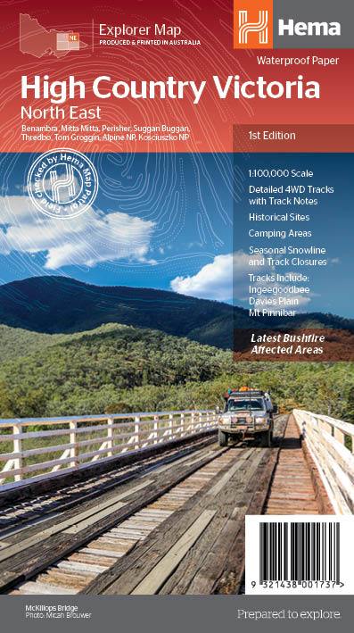
Victorian High Country NE 100K Hema Map
$14.95 $15.95
Afterpay is only available for orders between $50.00 and $1000.00 More info
From Omeo to Jindabyne | Waterproof Paper | Optional Lamination | Size: 695 mm x 995 mm
Explore the Northern High Country Like Never Before
This detailed topographic map is part of Hema’s acclaimed Victorian High Country Map Series, focused on the Northeast Borderlands, from Omeo to Jindabyne. Whether you're planning a multi-day 4WD trek, searching for secluded camping spots, or tracing historic stock routes, this map is your essential companion for navigating the rugged terrain and rich heritage of Victoria’s alpine north.
Meticulously field-checked by the Hema Map Patrol, every road, trail, hut, and feature has been verified on the ground—offering unparalleled accuracy and reliability for serious adventurers.
🧭 Key Features
| Feature | Details |
|---|---|
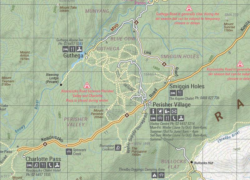
| 🛣 4WD Tracks | Clearly marked with track names, conditions, and seasonal closures |
| ⛺ Camping Areas | Both formal and informal sites, including bush camps |
| 🛖 Historic Huts | Dozens of heritage-listed huts with GPS positioning |
| 🏚 Old Townsites | Abandoned gold rush settlements and logging towns |
| 🌧 Seasonal Closures | Key track closure information to assist with route planning |
| 🏨 Accommodation | Local lodges, cabins, and guesthouses noted |
| 📏 Distance Markers | Road and trail distances for efficient trip planning |
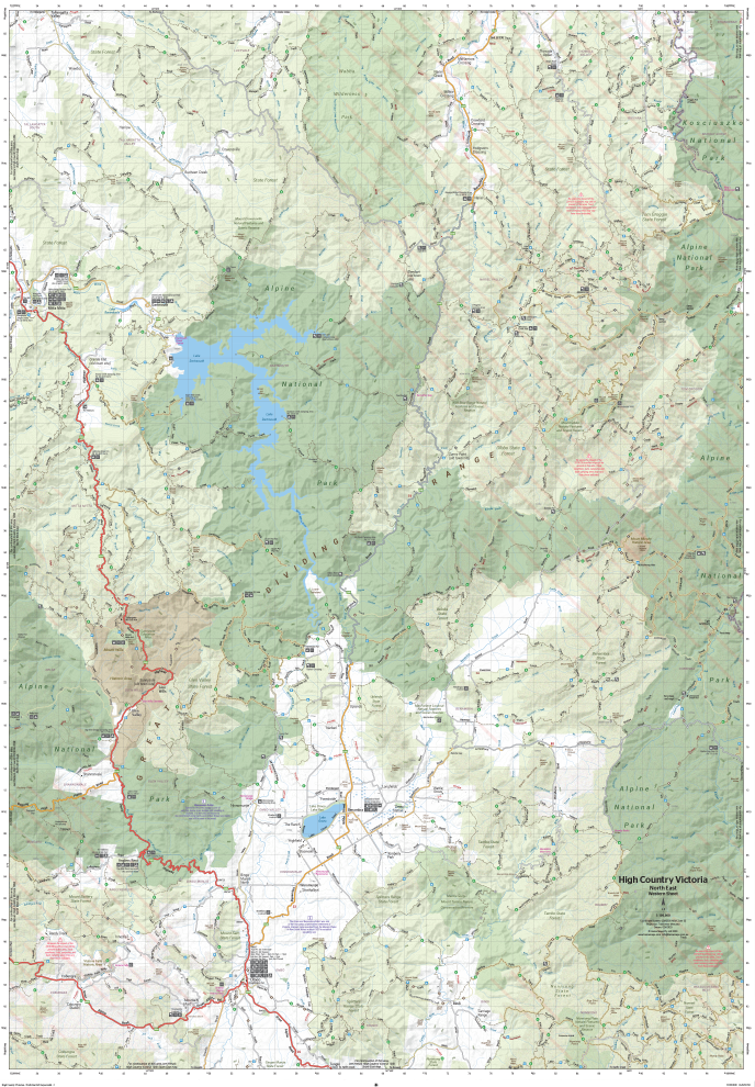
📍 Coverage Area
The map covers a vast portion of the Northern Victorian High Country, including:
-
Omeo
-
Mitta Mitta
-
Benambra
-
Davies Plain
-
Tom Groggin
-
Jindabyne
-
Limestone Creek
-
Cobberas and surrounds
Includes cross-border track detail for areas reaching into New South Wales, including the Snowy Mountains.
🗺 About the Map
| Specification | Detail |
|---|---|
| Scale | 1:100,000 |
| Size (Open) | 695 mm x 995 mm |
| Material | Waterproof, tear-resistant field-grade paper |
| Topography | Contours, rivers, ridgelines, forest boundaries |
| Overlay Data | Full Hema 4WD and touring POI database |
| Publisher | Hema Maps |
💧 Built for the Bush
Printed on durable waterproof and tear-resistant paper, this map is made to handle everything the High Country can throw at it—whether that’s mud, rain, snow, or the occasional campfire spill. Ideal for tucking into your glovebox or stashing in a daypack without fear of damage.
🖊 Optional Lamination
Want to mark out your trip, trace your completed route, or plan logistics for a club trip? Choose the laminated version, which allows you to use whiteboard markers or apply Mark-It-Dots without permanently marking your map. It’s also perfect for wall display—either in your office, your shed, or alongside your garage tool bench.
Note: Laminated maps are created by flattening out folded copies and encapsulating them in a high-quality 80-micron gloss laminate. Some light crease marks may be visible.
🏕 Ideal For:
-
4WD Enthusiasts
-
Hikers & Bushwalkers
-
Motorcycle Tourers
-
Backcountry Campers
-
Historians & Heritage Explorers
-
Outdoor Education Groups
-
Overland Clubs and Trip Leaders
🌄 Why Choose Hema's Victorian High Country Series?
✅ Field-Verified Accuracy – Hema’s Map Patrol ensures you’re never relying on guesswork.
✅ Incredible Topographic Detail – Built for elevation-conscious explorers.
✅ Track Reliability – Includes closures and conditions for safer off-road travel.
✅ A Lifetime Map – Designed for years of rugged use and planning.
🇦🇺 Proudly designed, field-checked, and printed in Australia
Frequently Asked Questions
What does the Victorian High Country NE 100K Hema Map cover?
The Victorian High Country NE 100K Hema Map covers 4WD tracks, camping areas, and travel routes for the region described in the product title. Most 4WD and camping guides in Mapworld's range include GPS coordinates, distance information, difficulty ratings, and notes on fuel stops and emergency contact points.
Is the Victorian High Country NE 100K Hema Map up to date?
Yes, this is the current edition. Mapworld stocks current editions from publishers including Hema Maps, Westprint, and others.
Is this product suitable for remote area travel?
Yes, 4WD maps and guides are designed for remote area navigation and trip planning. They include track conditions, fuel availability, camping spots, and safety information.
Does Mapworld ship the Victorian High Country NE 100K Hema Map across Australia?
Yes, Mapworld ships Australia-wide. Standard shipping is a flat $7 rate, with free standard shipping on orders over $75. Express options are available at checkout. Most orders placed before 2pm AEST on weekdays are dispatched same day.
Related Items


© 2026 Mapworld. Website designed by Genie Media
X