- Australia ▾
- Topographic
▾
- Australia AUSTopo 250k (2025)
- Australia 50k Geoscience maps
- Australia 100k Geoscience maps
- Australia 250k Geoscience maps
- Australia 1:1m Geoscience maps
- New Zealand 50k maps
- New Zealand 250k maps
- New South Wales 25k maps
- New South Wales 50k maps
- New South Wales 100k maps
- Queensland 10k maps
- Queensland 25k maps
- Queensland 50k maps
- Queensland 100k maps
- Western Australia 25k maps
- Western Australia 50k maps
- Western Australia 100k maps
- Compasses
- Software
- GPS Systems
- International ▾
- Wall Maps
▾
- World
- Australia & New Zealand
- Countries, Continents & Regions
- Historical
- Vintage National Geographic
- Australian Capital Territory
- New South Wales
- Northern Territory
- Queensland
- South Australia
- Tasmania
- Victoria
- Western Australia
- Celestial
- Children's
- Mining & Resources
- Wine Maps
- Healthcare
- Postcode Maps
- Electoral Maps
- Nautical ▾
- Flags
▾
- Australian Flag Sets & Banners
- Flag Bunting
- Handwavers
- Australian National Flags
- Aboriginal Flags
- Torres Strait Islander Flags
- International Flags
- Flagpoles & Accessories
- Australian Capital Territory Flags
- New South Wales Flags
- Northern Territory Flags
- Queensland Flags
- South Australia Flags
- Tasmania Flags
- Victoria Flags
- Western Australia Flags
- Gifts ▾
- Globes ▾
Dear valued customer. Please note that our checkout is not supported by old browsers. Please use a recent browser to access all checkout capabilities


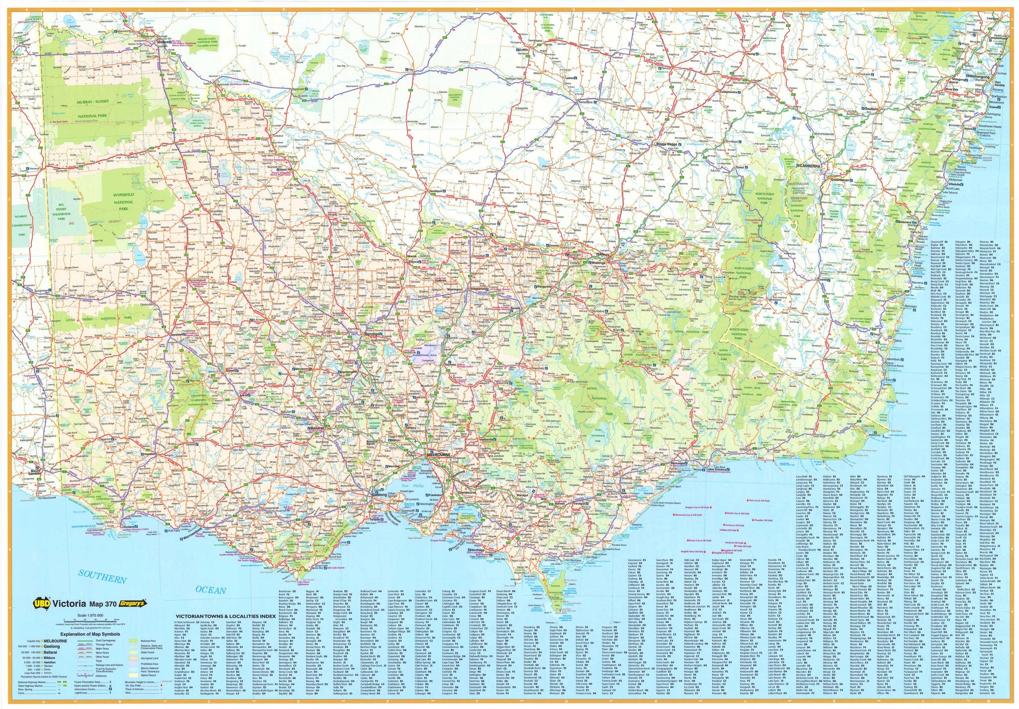
Victoria State & Suburban Map UBD 370
$13.95
Afterpay is only available for orders between $50.00 and $1000.00 More info
The definitive wall map for navigating Victoria and Greater Melbourne – combining state-wide reach with metropolitan precision
Explore Victoria’s diverse geography—from windswept coastlines to alpine ranges—with the 2024 edition of UBD Gregory’s Victoria State & Suburban Map. This double-sided laminated map offers unparalleled clarity and detail for both regional and urban planning. Whether you're a traveller, educator, business owner, logistics operator, or Melbourne local, this map is an indispensable tool for visualising routes, suburbs, towns, and key infrastructure across the state.
🗺️ Dual-Sided Coverage for Complete Context
🧭 Side One – Victoria State Map
Scale: 1:975,000
This side delivers a full overview of Victoria’s road and town network—ideal for long-distance travel, freight route mapping, or state-wide planning. Features include:
-
All major highways, national routes, and regional connectors
-
Dual carriageways, sealed and unsealed roads clearly marked
-
National parks, conservation areas, and nature reserves
-
Hundreds of towns and localities labelled and fully indexed
-
Boundaries for local government areas and regions
This side is especially useful for those planning road trips, managing rural logistics, or teaching geography at a secondary or tertiary level. From the Great Ocean Road to the Mallee, and from the Murray River to Wilsons Promontory, the state map paints a cohesive picture of Victoria’s vast and varied terrain.
🌆 Side Two – Greater Melbourne Suburban Map
Scale: 1:120,000
Zooming in on Victoria’s bustling capital, this detailed suburban map covers Melbourne and surrounding areas from:
-
Sunbury and Whittlesea in the north
-
Cowes and Phillip Island in the south
-
Melton and Bacchus Marsh in the west
-
Pakenham and the Dandenong Ranges in the east
Includes:
-
Clearly marked suburbs with postcodes
-
Arterial routes, motorways, ring roads, and main thoroughfares
-
Key features such as industrial areas, parks, airports, waterways, and rail corridors
-
Inset map of Geelong and the Bellarine Peninsula, expanding the urban focus beyond Melbourne
-
Full suburb index for fast navigation
This side is ideal for real estate professionals, delivery services, emergency planning, and education, offering granular insight into Melbourne’s growing suburban sprawl.
📐 Map Format & Construction
-
Flat Size: 1000 mm (H) x 700 mm (W)
-
Folded Size: 250 mm x 140 mm
-
Scales:
-
Victoria: 1:975,000
-
Melbourne Suburbs: 1:120,000
-
-
Edition: 2024
-
Published by: UBD Gregory’s, Australia’s most trusted name in cartography
🛡️ Premium Laminated Finishes Available
✅ Option 1 – Flat Laminated Map – $99.00
-
Supplied unfolded and encapsulated in 80-micron gloss laminate (both sides)
-
Waterproof, tear-resistant, and easy to clean
-
Perfect for wall display in offices, classrooms, council chambers, or home studies
-
Can be written on with whiteboard markers or used with map dots for interactive use
✅ Option 2 – Laminated Previously Folded Map – $49.95
-
The same full content and lamination, but made from a previously folded map
-
Great for budget-conscious buyers
-
Slight crease lines may be visible, but it remains fully laminated and functional
🌄 Why This Map Is a Must-Have
Victoria may be Australia’s second smallest state, but its diversity is extraordinary. This map reflects that diversity—from coastal icons like the Twelve Apostles, to the cultural heritage of the Goldfields, to the snow-capped peaks of the High Country, and the wheat fields and vineyards of the western districts.
Add to that Melbourne's ever-growing metropolitan landscape—Australia’s second-largest city and a hub of innovation, sport, education, and multicultural vibrancy—and this map becomes a tool of real utility.
📌 Perfect For:
-
Councils, urban planners, and infrastructure consultants
-
Teachers, students, and geography educators
-
Businesses managing fleets, service zones, or deliveries
-
Real estate professionals and property developers
-
Tourists, road trippers, and travellers planning Victorian journeys
-
Anyone who values a clear, reliable, and beautifully presented map of their state
Whether you're tracking transport routes, exploring new suburbs, or admiring the full sweep of Victoria’s natural beauty, the UBD Gregory’s Victoria State & Suburban Map (2024 Edition) offers both clarity and quality in one comprehensive format.
Navigate smarter. Plan with confidence. Showcase Victoria in full detail — with UBD.
Frequently Asked Questions
Where can I buy the Victoria State & Suburban Map UBD 370?
The Victoria State & Suburban Map UBD 370 is available to buy online from Mapworld, Australia's largest map and geographic product retailer, with fast shipping Australia-wide.
Is the Victoria State & Suburban Map UBD 370 in stock at Mapworld?
Mapworld maintains extensive stock across its map range and aims for fast dispatch. Orders placed before 2pm AEST on business days are typically dispatched the same day, with standard and express Australia-wide delivery options available.
What is Mapworld's returns policy?
Mapworld accepts returns on undamaged items in original condition. Contact Mapworld within 90 days of purchase to arrange a return or exchange.
Does Mapworld ship the Victoria State & Suburban Map UBD 370 across Australia?
Yes, Mapworld ships Australia-wide. Standard shipping is a flat $7 rate, with free standard shipping on orders over $75. Express options are available at checkout. Most orders placed before 2pm AEST on weekdays are dispatched same day.
Related Items


© 2026 Mapworld. Website designed by Genie Media
X