- Australia ▾
- Topographic
▾
- Australia AUSTopo 250k (2024)
- Australia 50k Geoscience maps
- Australia 100k Geoscience maps
- Australia 250k Geoscience maps
- Australia 1.1m Geoscience maps
- New Zealand 50k maps
- New Zealand 250k maps
- New South Wales 25k maps
- New South Wales 50k maps
- New South Wales 100k maps
- Queensland 10k maps
- Queensland 25k maps
- Queensland 50k maps
- Queensland 100k maps
- Compasses
- Software
- GPS Systems
- Orienteering
- International ▾
- Wall Maps
▾
- World
- Australia & New Zealand
- Countries, Continents & Regions
- Historical
- Vintage National Geographic
- Australian Capital Territory
- New South Wales
- Northern Territory
- Queensland
- South Australia
- Tasmania
- Victoria
- Western Australia
- Celestial
- Children's
- Mining & Resources
- Wine Maps
- Healthcare
- Postcode Maps
- Electoral Maps
- Nautical ▾
- Flags
▾
- Australian Flag Sets & Banners
- Flag Bunting
- Handwavers
- Australian National Flags
- Aboriginal Flags
- Torres Strait Islander Flags
- International Flags
- Flagpoles & Accessories
- Australian Capital Territory Flags
- New South Wales Flags
- Northern Territory Flags
- Queensland Flags
- South Australia Flags
- Tasmania Flags
- Victoria Flags
- Western Australia Flags
- Gifts ▾
- Globes ▾
Dear valued customer. Please note that our checkout is not supported by old browsers. Please use a recent browser to access all checkout capabilities


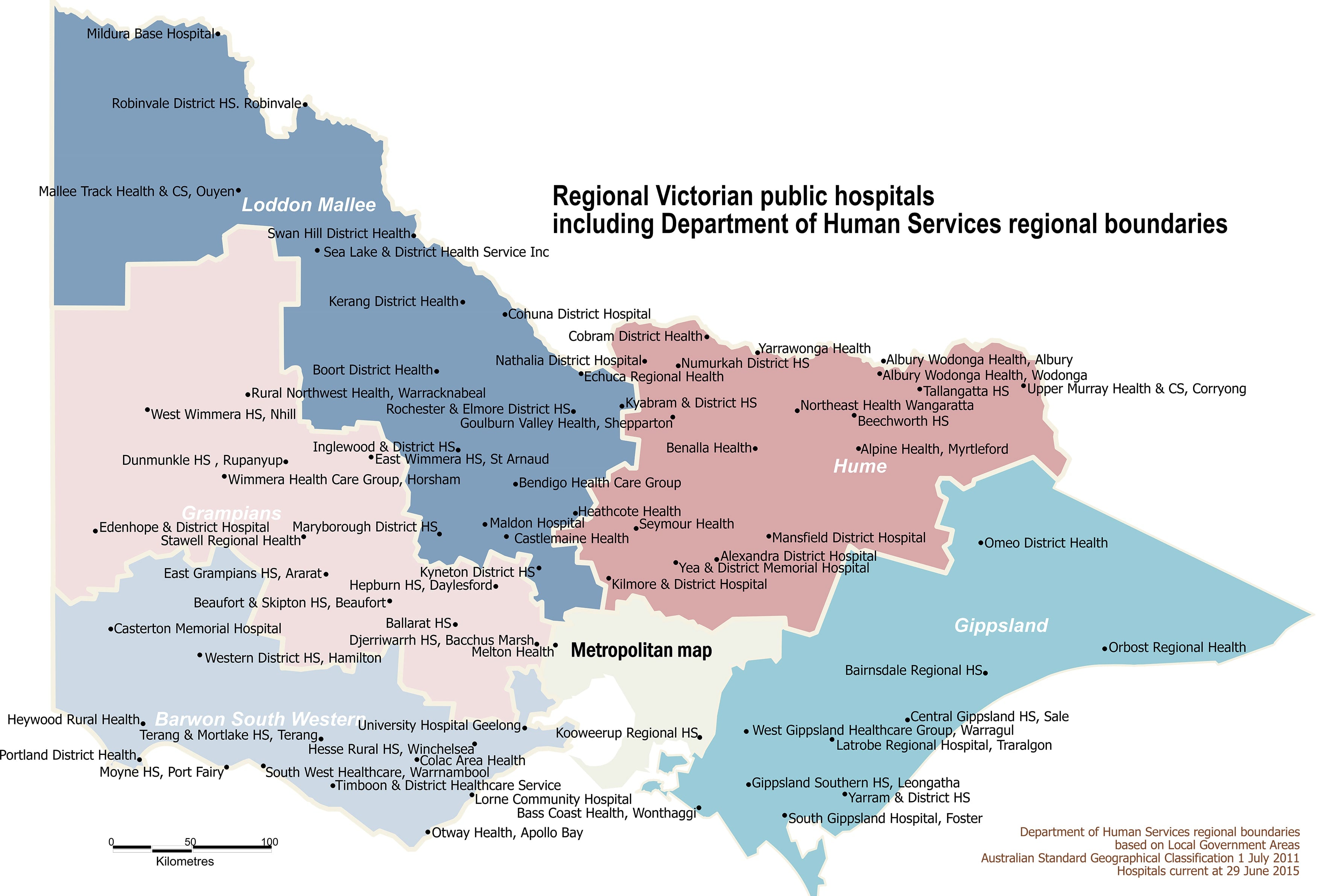
Victoria Rural Hospitals 1000 x 680mm Wall Map
$69.95
or make 4 interest-free payments of
$17.49 AUD
fortnightly with
![]() More info
More info
Size: 1000 mm (W) x 680 mm (H) | Laminated Finish Available
A practical and highly informative resource, the Victoria Rural Hospitals Map clearly displays the locations of all public hospitals across regional Victoria, along with the boundaries of Department of Human Services (DHS) regions. This map is an essential tool for anyone involved in health planning, logistics, emergency services, rural outreach, or public health management.
🗺️ What This Map Shows:
-
All Public Hospitals in rural and regional Victoria
-
Clearly defined DHS boundaries for effective regional planning
-
Major roads and localities for orientation and accessibility
-
Key geographic reference points to aid travel coordination
Whether you're working in health services administration, ambulance dispatch, or coordinating outreach across the state, this map provides a clear and practical visual overview of Victoria’s rural hospital infrastructure.
✅ Lamination Benefits
The map is available fully laminated, using high-quality 80-micron gloss laminate:
-
Use whiteboard markers to make temporary notes
-
Apply map dots to mark hospitals, service areas, or logistics hubs
-
Protects against tears, smudges, and moisture
-
Makes the map reusable and highly durable
📌 Perfect For:
-
Regional health administrators and planners
-
Hospital networks and health service providers
-
Government departments and public health teams
-
Emergency service coordination
-
Educational and training settings
📐 Specifications:
| Feature | Details |
|---|---|
| Title | Victoria Rural Hospitals Wall Map |
| Size | 1000 mm (width) x 680 mm (height) |
| Finish | Laminated (Gloss Encapsulation) |
| Content | Hospitals, DHS Boundaries, Major Roads |
| Made in | Australia |
Whether you're mapping patient transport routes, planning regional health access, or educating healthcare staff, this map delivers clarity, accuracy, and durability in one highly practical format.
Plan smarter. Deliver better. Map it with confidence.
