- Australia ▾
- Topographic
▾
- Australia AUSTopo 250k (2024)
- Australia 50k Geoscience maps
- Australia 100k Geoscience maps
- Australia 250k Geoscience maps
- Australia 1.1m Geoscience maps
- New Zealand 50k maps
- New Zealand 250k maps
- New South Wales 25k maps
- New South Wales 50k maps
- New South Wales 100k maps
- Queensland 10k maps
- Queensland 25k maps
- Queensland 50k maps
- Queensland 100k maps
- Compasses
- Software
- GPS Systems
- Orienteering
- International ▾
- Wall Maps
▾
- World
- Australia & New Zealand
- Countries, Continents & Regions
- Historical
- Vintage National Geographic
- Australian Capital Territory
- New South Wales
- Northern Territory
- Queensland
- South Australia
- Tasmania
- Victoria
- Western Australia
- Celestial
- Children's
- Mining & Resources
- Wine Maps
- Healthcare
- Postcode Maps
- Electoral Maps
- Nautical ▾
- Flags
▾
- Australian Flag Sets & Banners
- Flag Bunting
- Handwavers
- Australian National Flags
- Aboriginal Flags
- Torres Strait Islander Flags
- International Flags
- Flagpoles & Accessories
- Australian Capital Territory Flags
- New South Wales Flags
- Northern Territory Flags
- Queensland Flags
- South Australia Flags
- Tasmania Flags
- Victoria Flags
- Western Australia Flags
- Gifts ▾
- Globes ▾
Dear valued customer. Please note that our checkout is not supported by old browsers. Please use a recent browser to access all checkout capabilities
Victoria Federal Electoral Divisions and Local Government Areas Map - Melbourne & Area
$59.95
or make 4 interest-free payments of
$14.99 AUD
fortnightly with
![]() More info
More info
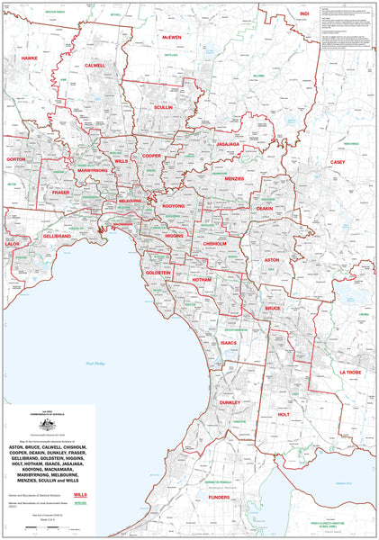
A comprehensive and professional wall map of Melbourne’s political and administrative landscape
Explore Melbourne's complex political geography with this detailed map of Victoria's Federal Electoral Divisions and Local Government Areas, focused specifically on the Greater Melbourne region. This high-quality map is a vital resource for educators, civic planners, government offices, campaign managers, and engaged citizens who want to better understand the region's federal representation and local administrative boundaries.
🗺️ Detailed Coverage of Melbourne's Electoral and Local Government Boundaries
This full-colour map clearly illustrates the names and boundaries of both federal electoral divisions and local government areas (LGAs) across Melbourne and its surrounds. It is designed to be visually clear and highly informative, helping you see at a glance how electoral and municipal lines intersect across the metropolitan region.
🗳️ Includes Federal Electoral Divisions:
-
Aston
-
Bruce
-
Calwell
-
Chisholm
-
Cooper
-
Deakin
-
Dunkley
-
Fraser
-
Gellibrand
-
Goldstein
-
Higgins
-
Holt
-
Hotham
-
Isaacs
-
Jagajaga
-
Kooyong
-
Macnamara
-
Maribyrnong
-
Melbourne
-
Menzies
-
Scullin
-
Wills
Each division is clearly labelled and outlined with distinct boundaries, ensuring legibility and ease of use for electoral research, community engagement, or education.
🏛️ Includes Local Government Areas (LGAs):
-
All corresponding local councils for the above divisions are included, with names and boundaries clearly marked to provide a complete picture of local governance alongside federal representation.
📐 Map Specifications
| Feature | Description |
|---|---|
| Map Title | Victoria Federal Electoral Divisions & LGAs – Melbourne & Area |
| Dimensions | 1000mm (W) x 700mm (H) |
| Content | Federal divisions + Local Government Areas |
| Scale | Designed for readability and accuracy at a glance |
| Publisher | Professionally produced in Australia |
🎨 Available Formats
1. Heavyweight Paper Version
-
Printed on 160gsm premium matte paper.
-
Ideal for framing under glass in boardrooms, classrooms, offices, or civic centres.
-
Matte surface reduces glare and enhances clarity.
2. Laminated Version – Durable & Wipeable
-
Encapsulated in two sheets of 80-micron gloss laminate (160 microns total thickness).
-
Designed for maximum durability: water-resistant, tear-resistant, and stain-proof.
-
Use whiteboard markers to annotate directly on the surface—perfect for electoral planning, community workshops, or presentations.
-
Easy to wipe clean and reuse, making it highly practical for ongoing reference and engagement.
3. Canvas Version (By Request)
-
Available on 395gsm HP Professional Matte Canvas, using archival pigment inks.
-
Fade-resistant, richly detailed, and ideal for decorative or heritage display.
-
Optional wooden hang rails can be added top and bottom for a polished, easy-to-hang finish.
-
Please allow 10 working days for hang-railed canvas orders, which are assembled by our professional framer.
🛠️ Customisation Available
Need something more specific? We can produce individual, high-detail maps of any single federal electoral division listed above. These maps can include additional features such as street names, polling places, or community facilities depending on your needs.
Contact us for tailored mapping solutions, bulk orders, or corporate branding options.
📍 Perfect For:
-
Government agencies & departments
-
Electoral offices & campaign teams
-
Council chambers & planning departments
-
Schools & universities
-
Libraries, civic halls & community centres
-
Anyone seeking a clear, authoritative reference of Melbourne's political divisions
🇦🇺 Made in Australia
Each map is designed, printed, and finished right here in Australia, using high-quality materials and professional production standards. Whether for practical use or display, this map reflects our commitment to clarity, precision, and long-term durability.
🛒 Order Yours Today
Upgrade your understanding of Melbourne’s federal and local governance with this professionally produced map. Whether for work, teaching, planning, or display, the Victoria Federal Electoral Divisions & Local Government Areas Map is a practical and beautiful addition to any space.
Available in paper, laminated, or canvas formats – built to last, made to inform.


