- Australia ▾
- Topographic
▾
- Australia AUSTopo 250k (2025)
- Australia 50k Geoscience maps
- Australia 100k Geoscience maps
- Australia 250k Geoscience maps
- Australia 1.1m Geoscience maps
- New Zealand 50k maps
- New Zealand 250k maps
- New South Wales 25k maps
- New South Wales 50k maps
- New South Wales 100k maps
- Queensland 10k maps
- Queensland 25k maps
- Queensland 50k maps
- Queensland 100k maps
- Compasses
- Software
- GPS Systems
- Orienteering
- International ▾
- Wall Maps
▾
- World
- Australia & New Zealand
- Countries, Continents & Regions
- Historical
- Vintage National Geographic
- Australian Capital Territory
- New South Wales
- Northern Territory
- Queensland
- South Australia
- Tasmania
- Victoria
- Western Australia
- Celestial
- Children's
- Mining & Resources
- Wine Maps
- Healthcare
- Postcode Maps
- Electoral Maps
- Nautical ▾
- Flags
▾
- Australian Flag Sets & Banners
- Flag Bunting
- Handwavers
- Australian National Flags
- Aboriginal Flags
- Torres Strait Islander Flags
- International Flags
- Flagpoles & Accessories
- Australian Capital Territory Flags
- New South Wales Flags
- Northern Territory Flags
- Queensland Flags
- South Australia Flags
- Tasmania Flags
- Victoria Flags
- Western Australia Flags
- Gifts ▾
- Globes ▾
Dear valued customer. Please note that our checkout is not supported by old browsers. Please use a recent browser to access all checkout capabilities
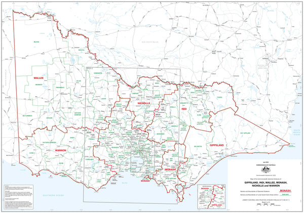
Victoria Federal Electoral Divisions and Local Government Areas Map - Gippsland & Area
$59.95
or make 4 interest-free payments of
$14.99 AUD
fortnightly with
![]() More info
More info
Victoria — Federal Electoral Divisions & LGAs (Gippsland & Region)
1000 × 700 mm • Paper / Laminated / Laminated + Hang Rails / Canvas / Canvas + Hang Rails • Made in Australia
An authoritative, large-format reference of Gippsland and surrounding regions showing six key federal electoral divisions alongside all Local Government Areas (LGAs). Designed for clarity and precision, it’s ideal for civic institutions, government offices, planners, classrooms, libraries, and anyone who needs a dependable picture of Victoria’s political and administrative structure.
🔍 Coverage at a Glance
-
🗳️ Federal electoral divisions (labelled & colour-coded):
Gippsland, Indi, Mallee, Monash, Nicholls, Wannon
Boundaries reflect the latest redistribution. -
🏛️ Local Government Areas (LGAs):
Council names and borders clearly shown to reveal how federal and local lines intersect. -
🗺 Basemap context:
Major towns, highways, and regional centres for quick geographic orientation. -
👁️ Wall-readable cartography:
Calm palette, crisp typography, and clear contrasts for legibility at a distance.
Why This Map Works
-
Instant orientation: See electorates and LGAs together, at a glance.
-
Planning-ready: Perfect for engagement, policy, logistics, and teaching civic structure.
-
High-resolution output: Sharp linework and labels for close reading and wall display.
🎨 Finishes & Display Options
-
📄 Paper (160 gsm Matte)
-
Premium matte stock with low glare and crisp detail—ideal for framing under glass.
-
Flat-rolled by default; folded on request (paper only).
-
-
💧 Laminated (True Encapsulation)
-
Printed on 120 gsm, sealed in 2 × 80-micron gloss laminate (edge-sealed).
-
Wipe-clean • Tear-resistant • Moisture-resistant — annotate with whiteboard markers and use map dots.
-
-
🪵 Laminated + Timber Hang Rails (Ready to Hang)
-
Natural lacquered timber rails (top & bottom) + top hanging cord—hang from a single hook.
-
⏱️ Custom finish—please allow up to 10 working days for rail fitting.
-
-
🖼️ Canvas (HP 395 gsm Professional Matte)
-
Gallery-grade, low-glare canvas printed with archival pigment inks for excellent fade resistance.
-
-
🪵 Canvas + Timber Hang Rails
-
Same premium canvas finished with lacquered timber rails + top hanging cord—gallery-style, ready to hang.
-
⏱️ Custom finish—please allow up to 10 working days for rail fitting.
-
📐 Specifications
| Attribute | Description |
|---|---|
| Map Title | Victoria — Federal Electoral Divisions & LGAs (Gippsland & Region) |
| Size | 1000 mm (W) × 700 mm (H) |
| Content | Six federal divisions + all LGAs, with major towns, highways, and regional centres |
| Formats | Paper • Laminated • Laminated + Hang Rails • Canvas • Canvas + Hang Rails |
| Paper | 160 gsm matte |
| Laminate | 2 × 80-micron gloss (true encapsulation) |
| Canvas | HP 395 gsm Professional Matte |
| Inks | Archival pigment-based (fade-resistant) |
| Origin | Made in Australia |
🛠️ Customisation
Need to zoom in on a single electorate? We can produce division-specific maps and add street overlays, polling places, community facilities, drive-time rings, branding, or alternate sizes. Bulk and corporate solutions available.
🎯 Perfect For
Government & electoral offices • Councils & planning teams • Community groups & NGOs • Schools & universities • Libraries & civic spaces • Consultants & regional stakeholders
🤝 Our Commitment
-
Local craftsmanship: Designed, printed, and finished in Australia for consistent quality and fast support.
-
Archival quality: Premium papers/canvas and pigment inks ensure long-lasting clarity.
-
Clarity first: Legend, symbology, and label hierarchies tuned for wall readability.
-
Built to last: True-encapsulation lamination and 395 gsm canvas stand up to daily use.
-
Packed with care: Hand-checked and securely shipped—arrives clean and display-ready.
-
Flexible options: We tailor overlays, branding, and sizing to your workflow.
🛒 Put Gippsland & Region’s political geography on the wall—clear, durable, and ready for daily decision-making.


