- Australia ▾
- Topographic
▾
- Australia AUSTopo 250k (2024)
- Australia 50k Geoscience maps
- Australia 100k Geoscience maps
- Australia 250k Geoscience maps
- Australia 1.1m Geoscience maps
- New Zealand 50k maps
- New Zealand 250k maps
- New South Wales 25k maps
- New South Wales 50k maps
- New South Wales 100k maps
- Queensland 10k maps
- Queensland 25k maps
- Queensland 50k maps
- Queensland 100k maps
- Compasses
- Software
- GPS Systems
- Orienteering
- International ▾
- Wall Maps
▾
- World
- Australia & New Zealand
- Countries, Continents & Regions
- Historical
- Vintage National Geographic
- Australian Capital Territory
- New South Wales
- Northern Territory
- Queensland
- South Australia
- Tasmania
- Victoria
- Western Australia
- Celestial
- Children's
- Mining & Resources
- Wine Maps
- Healthcare
- Postcode Maps
- Electoral Maps
- Nautical ▾
- Flags
▾
- Australian Flag Sets & Banners
- Flag Bunting
- Handwavers
- Australian National Flags
- Aboriginal Flags
- Torres Strait Islander Flags
- International Flags
- Flagpoles & Accessories
- Australian Capital Territory Flags
- New South Wales Flags
- Northern Territory Flags
- Queensland Flags
- South Australia Flags
- Tasmania Flags
- Victoria Flags
- Western Australia Flags
- Gifts ▾
- Globes ▾
Dear valued customer. Please note that our checkout is not supported by old browsers. Please use a recent browser to access all checkout capabilities


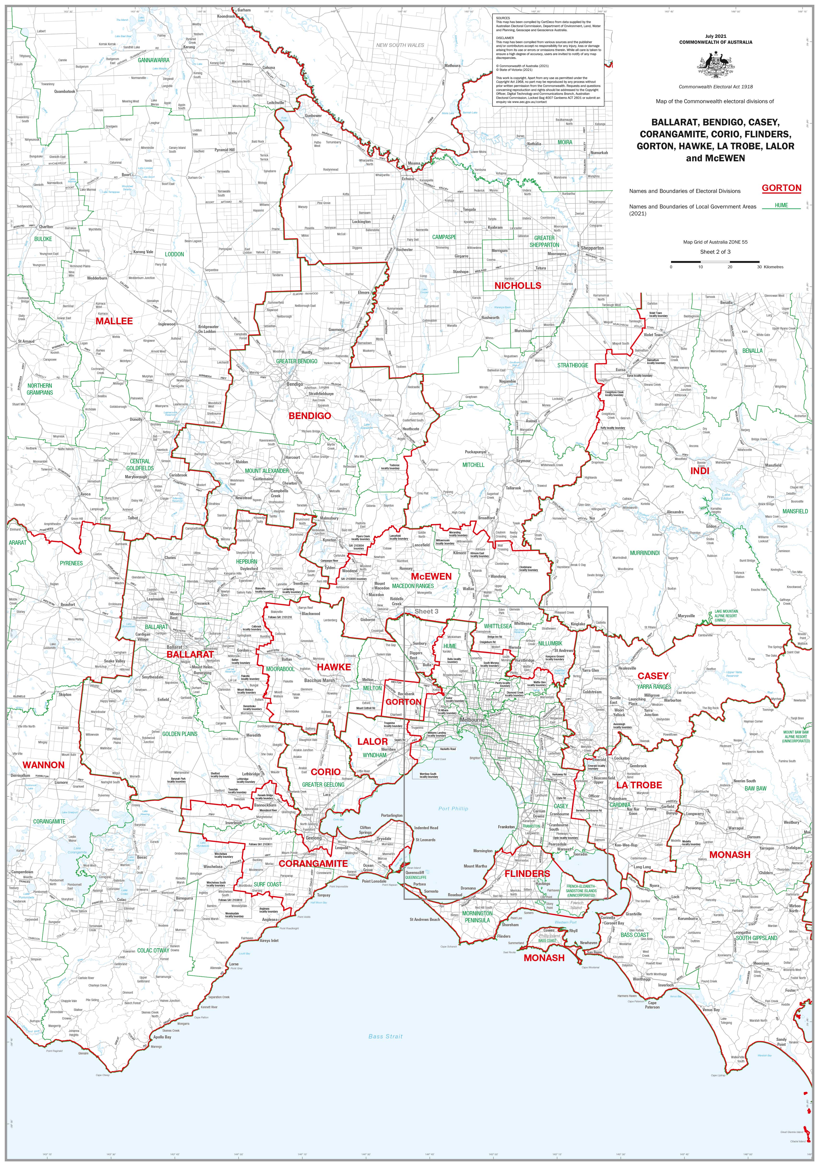
Victoria Federal Electoral Divisions and Local Government Areas Map - Ballarat & Area
$59.95
or make 4 interest-free payments of
$14.99 AUD
fortnightly with
![]() More info
More info
Covers Federal Electorates and LGAs Across Central and Western Victoria
Size: 1000 mm x 700 mm
Custom divisions available on request
🗺️ Overview
This professionally produced map provides a detailed overview of federal electoral divisions and local government areas in and around Ballarat and regional Victoria. Ideal for political offices, local councils, educators, or planning professionals, the map features clearly marked boundaries, names, and zones across both federal and local jurisdictions.
Whether you're managing community engagement, conducting policy research, or simply seeking to understand regional governance, this map offers an accessible and accurate reference for civic geography.
✅ Federal Electoral Divisions Included
-
Ballarat
-
Bendigo
-
Casey
-
Corangamite
-
Corio
-
Flinders
-
Gorton
-
Hawke
-
La Trobe
-
Lalor
-
McEwen
Each division is clearly outlined and labelled for fast identification and comparison across regions.
🏛️ Map Features
| Feature | Benefit |
|---|---|
| Federal Division Boundaries | Clear, colour-coded outlines for easy visual reference |
| Local Government Area Boundaries | LGA names and borders shown alongside electorates |
| High-Resolution Detail | Ideal for both wall display and practical use |
| Updated Mapping Data | Based on current electoral and local boundaries |
📐 Product Specifications
-
Title: Victoria Federal Electoral Divisions & LGAs – Ballarat & Region
-
Size: 1000 mm (W) x 700 mm (H)
-
Finish Options: Available as either paper or laminated.
-
Print Quality: High-resolution for legibility and clarity
-
Customisation: Individual division maps available – contact us for details
🎯 Perfect For:
-
Electoral offices and political campaign teams
-
Local government authorities and civic planners
-
Community organisations and advocacy groups
-
Schools, universities, and civics education
-
Professional offices and regional consultants
-
Map collectors and policy researchers
Understand the Political Landscape of Regional Victoria
Whether you're tracing the reach of a federal seat or comparing overlapping LGA boundaries, this Ballarat & Area Electoral and Local Government Map delivers precision and readability in a user-friendly format.
🛒 Add to your cart today, or contact us to request custom maps of individual divisions tailored to your needs.
