- Australia ▾
- Topographic
▾
- Australia AUSTopo 250k (2025)
- Australia 50k Geoscience maps
- Australia 100k Geoscience maps
- Australia 250k Geoscience maps
- Australia 1:1m Geoscience maps
- New Zealand 50k maps
- New Zealand 250k maps
- New South Wales 25k maps
- New South Wales 50k maps
- New South Wales 100k maps
- Queensland 10k maps
- Queensland 25k maps
- Queensland 50k maps
- Queensland 100k maps
- Western Australia 25k maps
- Western Australia 50k maps
- Western Australia 100k maps
- Compasses
- Software
- GPS Systems
- International ▾
- Wall Maps
▾
- World
- Australia & New Zealand
- Countries, Continents & Regions
- Historical
- Vintage National Geographic
- Australian Capital Territory
- New South Wales
- Northern Territory
- Queensland
- South Australia
- Tasmania
- Victoria
- Western Australia
- Celestial
- Children's
- Mining & Resources
- Wine Maps
- Healthcare
- Postcode Maps
- Electoral Maps
- Nautical ▾
- Flags
▾
- Australian Flag Sets & Banners
- Flag Bunting
- Handwavers
- Australian National Flags
- Aboriginal Flags
- Torres Strait Islander Flags
- International Flags
- Flagpoles & Accessories
- Australian Capital Territory Flags
- New South Wales Flags
- Northern Territory Flags
- Queensland Flags
- South Australia Flags
- Tasmania Flags
- Victoria Flags
- Western Australia Flags
- Gifts ▾
- Globes ▾
Dear valued customer. Please note that our checkout is not supported by old browsers. Please use a recent browser to access all checkout capabilities


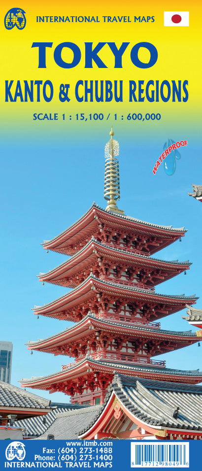
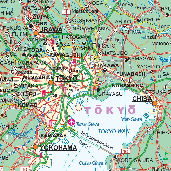
Japan Tokyo and Kanto/Chubu Region ITMB Map
$45.00
Afterpay is only available for orders between $50.00 and $1000.00 More info
Double-Sided Travel Map Featuring Tokyo and Central Japan
Scale: 1:15,000 (Tokyo) / 1:850,000 (Regional)
Size: 700 mm x 1000 mm
Optional Lamination Available
Navigate one of the world’s most dynamic cities and explore the cultural heart of Japan with this double-sided travel map from ITMB (International Travel Maps). The Japan: Tokyo & Kanto/Chubu Region Map offers a detailed street-level guide to Tokyo on one side, and a broad regional map of central Japan on the reverse—perfect for visitors seeking to explore beyond the capital.
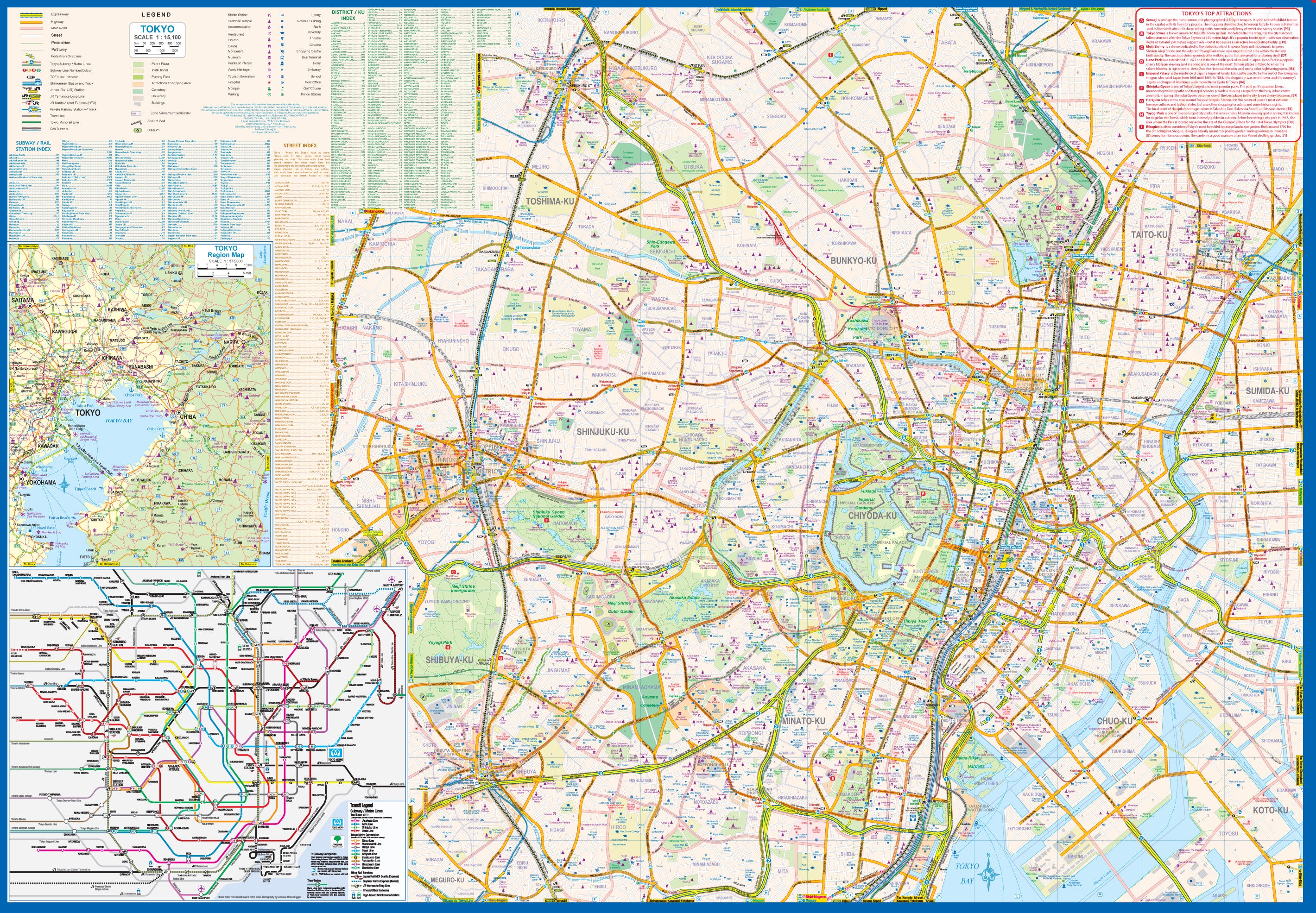
🗺️ Side 1: Central Tokyo City Map (Scale 1:15,000)
Capturing Tokyo in its entirety is no easy task. As one of the most densely populated and intricately networked cities in the world, the map focuses on the core tourist and commercial areas, extending from:
-
Shibuya and Shinjuku in the west (known for shopping, nightlife, and urban energy)
-
Across to Asakusa, home of the famous Senso-ji Temple, in the east
Tokyo Features:
-
🚇 Complete subway network, with station names and line identifiers
-
🚅 Mainline rail routes, including JR lines, private railways, and the Shinkansen terminal
-
✈️ Monorail to Haneda Airport
-
🏯 Major landmarks, including the Imperial Palace, Tokyo Tower, Ueno Park, and Akihabara
-
✈️ Inset of Narita International Airport, including rail access into central Tokyo
-
🗺️ Separate large inset of the Tokyo rail/subway network for easier navigation
Tokyo can be overwhelming for even seasoned travellers. This map provides the clarity and orientation needed to navigate with confidence—on foot, by train, or underground.
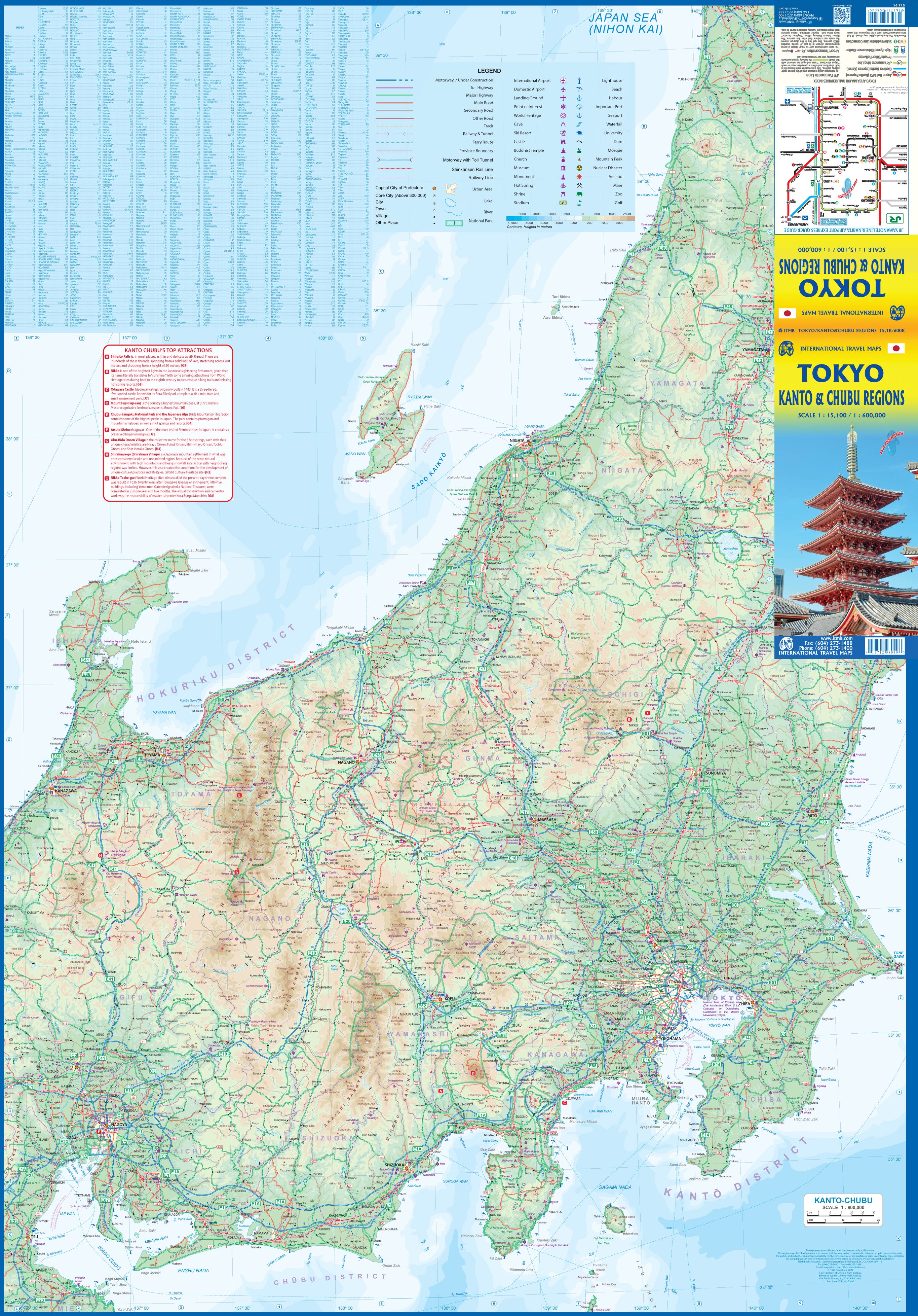
🧭 Side 2: Kanto and Chubu Regional Map (Scale 1:850,000)
The reverse side features a regional map of central Japan, covering an area stretching:
-
As far west as Nagoya
-
North to Yamagata
-
Including Mount Fuji, Izu Peninsula, and various accessible islands
This section is ideal for day trips and short excursions from Tokyo, with notable cities and destinations clearly marked.
Highlights Include:
-
🏰 Odawara Castle
-
⛩️ The sacred shrines and forests of Nikko
-
🗻 Mount Fuji, Japan’s most iconic peak
-
🚉 Shinkansen routes and major expressways
-
⚓ Shimoda, one of the first ports opened to the West
Whether you're planning a rail adventure, tracing historical routes, or exploring natural wonders, this regional map opens the door to a vast range of experiences beyond Tokyo.
Optional Laminated Edition
Prefer something more durable? We offer this map encapsulated in high-quality 80-micron laminate, giving it a tough, wipe-clean surface.
-
✅ Draw on it with whiteboard markers
-
✅ Apply map dots to mark places visited or planned
-
✅ Protects against tears, spills, and daily wear
Note: As this is laminated from the original folded edition, slight fold lines may remain visible, though they do not affect usability.
📐 Specifications
| Feature | Detail |
|---|---|
| Map Title | Japan: Tokyo & Kanto/Chubu Region Map |
| Publisher | ITMB (International Travel Maps) |
| Scale | 1:15,000 (Tokyo) / 1:850,000 (Region) |
| Size (flat) | 700 mm x 1000 mm |
| Format | Folded map (optional laminated version) |
| Language | English |
| Printed in | Canada |
🧳 Ideal For:
-
✈️ Travellers and first-time visitors to Tokyo and central Japan
-
🧭 Railpass holders exploring by Shinkansen and local trains
-
🗺️ Tour planners and educators needing a compact yet detailed visual reference
-
🏨 Hotel lobbies and travel agencies offering guidance to clients
-
🎁 Japan enthusiasts and map collectors
With one side focused on Tokyo’s bustling urban core and the other offering a broad view of central Japan’s natural and cultural landmarks, this map is a practical and elegant tool for anyone exploring Japan’s most iconic regions. From the bullet trains to the temples, from Shinjuku to the summit of Fuji, this is your gateway to understanding Japan’s geography with confidence and clarity.
Tokyo may be vast, but with the right map in hand, it becomes remarkably navigable.
Frequently Asked Questions
Where can I buy the Japan Tokyo and Kanto/Chubu Region ITMB Map?
The Japan Tokyo and Kanto/Chubu Region ITMB Map is available to buy online from Mapworld, Australia's largest map and geographic product retailer, with fast shipping Australia-wide.
Is the Japan Tokyo and Kanto/Chubu Region ITMB Map in stock at Mapworld?
Mapworld maintains extensive stock across its map range and aims for fast dispatch. Orders placed before 2pm AEST on business days are typically dispatched the same day, with standard and express Australia-wide delivery options available.
What is Mapworld's returns policy?
Mapworld accepts returns on undamaged items in original condition. Contact Mapworld within 90 days of purchase to arrange a return or exchange.
Does Mapworld ship the Japan Tokyo and Kanto/Chubu Region ITMB Map across Australia?
Yes, Mapworld ships Australia-wide. Standard shipping is a flat $7 rate, with free standard shipping on orders over $75. Express options are available at checkout. Most orders placed before 2pm AEST on weekdays are dispatched same day.
Related Items


© 2026 Mapworld. Website designed by Genie Media
X