- Australia ▾
- Topographic
▾
- Australia AUSTopo 250k (2024)
- Australia 50k Geoscience maps
- Australia 100k Geoscience maps
- Australia 250k Geoscience maps
- Australia 1.1m Geoscience maps
- New Zealand 50k maps
- New Zealand 250k maps
- New South Wales 25k maps
- New South Wales 50k maps
- New South Wales 100k maps
- Queensland 10k maps
- Queensland 25k maps
- Queensland 50k maps
- Queensland 100k maps
- Compasses
- Software
- GPS Systems
- Orienteering
- International ▾
- Wall Maps
▾
- World
- Australia & New Zealand
- Countries, Continents & Regions
- Historical
- Vintage National Geographic
- Australian Capital Territory
- New South Wales
- Northern Territory
- Queensland
- South Australia
- Tasmania
- Victoria
- Western Australia
- Celestial
- Children's
- Mining & Resources
- Wine Maps
- Healthcare
- Postcode Maps
- Electoral Maps
- Nautical ▾
- Flags
▾
- Australian Flag Sets & Banners
- Flag Bunting
- Handwavers
- Australian National Flags
- Aboriginal Flags
- Torres Strait Islander Flags
- International Flags
- Flagpoles & Accessories
- Australian Capital Territory Flags
- New South Wales Flags
- Northern Territory Flags
- Queensland Flags
- South Australia Flags
- Tasmania Flags
- Victoria Flags
- Western Australia Flags
- Gifts ▾
- Globes ▾
Dear valued customer. Please note that our checkout is not supported by old browsers. Please use a recent browser to access all checkout capabilities


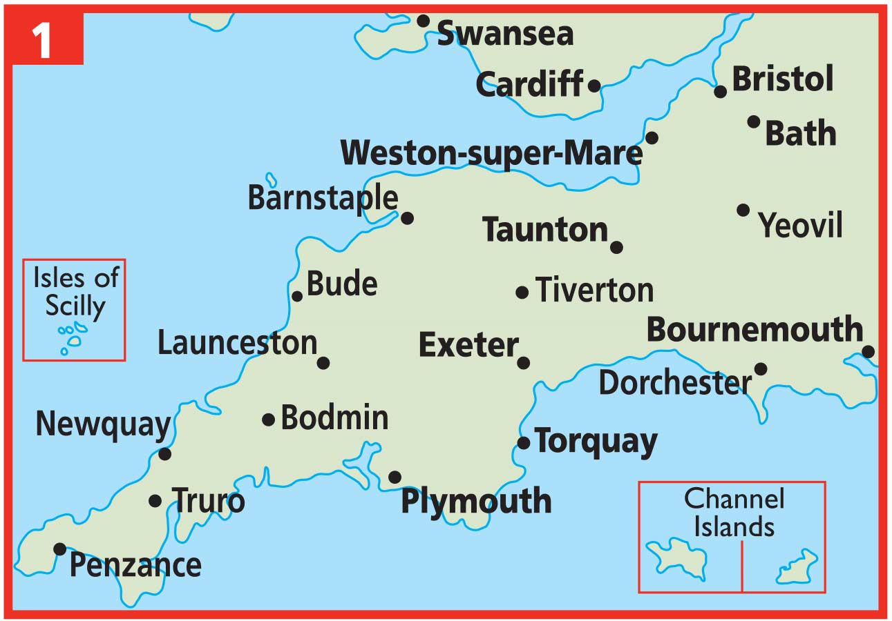


The West Country & South Wales AA Road Map 1
Sold Out
Afterpay is only available for orders between $50.00 and $1000.00 More info
Scale: 1:200,000 | Folded Paper Map | 2024 Edition
Explore Cornwall, Devon, Somerset, Bristol, South Wales & More
🌄 Discover the Charm of Britain’s Southwest and Celtic Coast
From the wave-battered cliffs of Cornwall to the verdant hills of South Wales, the West Country & South Wales region is a treasure trove of dramatic coastlines, historic towns, national parks, and vibrant cultural heritage. Whether you’re embarking on a coastal caravan tour, winding through moorland villages, or tracing the industrial roots of Welsh cities, this AA Road Map 1 is your indispensable guide to navigating it all with confidence and clarity.
Created by the trusted cartographers at the Automobile Association (AA) — a name synonymous with precision mapping in the UK — this beautifully designed, large-format road map offers the perfect balance between detail and usability. It’s more than just a map; it’s a travel tool built for discovery.
🗺️ Regional Coverage
This map spans a broad and rich section of the UK, including:
-
Cornwall – from St Ives to Land’s End and beyond
-
Devon – Dartmoor, Exmoor, Exeter, Torbay and the Jurassic Coast
-
Somerset – including Bath, Glastonbury, Wells, and the Quantock Hills
-
Bristol & Gloucestershire – urban and historic heartlands
-
South Wales – including Cardiff, Swansea, Newport, and the Gower Peninsula
With a scale of 1:200,000 (3 miles to 1 inch), the map gives an excellent overview of the road network while still showing plenty of local detail — perfect for planning longer drives or zooming in on hidden gems.
🧭 Features at a Glance
🛣️ Fully Updated Road Network
All motorways, dual carriageways, A-roads and local routes are clearly marked. Road numbers, toll routes, and service areas are included, along with distances for easy trip planning.
🚦 Speed Camera Alerts
Speed camera locations and the posted limits are shown — a thoughtful inclusion for safety-conscious drivers and those unfamiliar with local enforcement.
🏞️ National Parks & Natural Highlights
The map highlights important landscapes such as:
-
Dartmoor & Exmoor National Parks
-
The Gower Peninsula
-
Brecon Beacons
-
Mendip Hills
-
The Forest of Dean
🏕️ Touring and Visitor Essentials
Symbols indicate:
-
Caravan parks & campsites
-
National Trust and English Heritage sites
-
Welsh & Scottish Heritage sites
-
Tourist attractions & places of interest
🗺️ Detailed City Insets
Includes 15 inset maps of key cities and towns, giving you a zoomed-in view for urban navigation:
-
Bristol
-
Bath
-
Cardiff
-
Newport
-
Swansea
-
Poole
-
Exeter
-
Plymouth
-
Torquay
-
Paignton
-
Brixham
-
Newquay
-
Weston-super-Mare
-
Taunton
-
Bournemouth
Each inset features detailed road layouts, parking areas, and key urban landmarks — great for navigating unfamiliar streets or planning city stops.
📍 Index & Navigation Aids
A full place name index allows for fast look-ups, while clear road numbering and sign-post-style labels make it easy to plot routes with minimal fuss.
📏 Specifications
| Feature | Description |
|---|---|
| Map Title | The West Country & South Wales – AA Road Map 1 |
| Scale | 1:200,000 (3 miles = 1 inch) |
| Format | Folded Paper Map |
| Sheet Size (Unfolded) | 1200 mm x 980 mm |
| Edition | 2024 |
| Publisher | Automobile Association (AA) |
| Legend Language | English |
| Printed in | United Kingdom |
🚗 Who Is This Map For?
-
Road Trippers & Holidaymakers: Ideal for those exploring Devon, Cornwall, and Wales by car, camper, or motorcycle.
-
Outdoor Enthusiasts: Find walking trails, national parks, and natural beauty with ease.
-
Families on Vacation: Plan visits to castles, coastlines, attractions, and museums.
-
Caravanners & Campers: Pinpoint campsites and plan fuel stops along scenic routes.
-
Educators & Map Collectors: A practical, informative addition to any classroom or collection.
🛒 Why Buy This Map?
Digital navigation is handy — until your mobile signal disappears halfway through Dartmoor. Having a paper map gives you control, context, and the ability to see the whole journey at once. With its crystal-clear layout and thoughtful features, the West Country & South Wales AA Road Map is a must-have for anyone travelling the region.
Plan better. Explore deeper. Drive smarter.
Add this map to your travel toolkit and take the scenic route with confidence.


