- Australia ▾
- Topographic
▾
- Australia AUSTopo 250k (2024)
- Australia 50k Geoscience maps
- Australia 100k Geoscience maps
- Australia 250k Geoscience maps
- Australia 1.1m Geoscience maps
- New Zealand 50k maps
- New Zealand 250k maps
- New South Wales 25k maps
- New South Wales 50k maps
- New South Wales 100k maps
- Queensland 10k maps
- Queensland 25k maps
- Queensland 50k maps
- Queensland 100k maps
- Compasses
- Software
- GPS Systems
- Orienteering
- International ▾
- Wall Maps
▾
- World
- Australia & New Zealand
- Countries, Continents & Regions
- Historical
- Vintage National Geographic
- Australian Capital Territory
- New South Wales
- Northern Territory
- Queensland
- South Australia
- Tasmania
- Victoria
- Western Australia
- Celestial
- Children's
- Mining & Resources
- Wine Maps
- Healthcare
- Postcode Maps
- Electoral Maps
- Nautical ▾
- Flags
▾
- Australian Flag Sets & Banners
- Flag Bunting
- Handwavers
- Australian National Flags
- Aboriginal Flags
- Torres Strait Islander Flags
- International Flags
- Flagpoles & Accessories
- Australian Capital Territory Flags
- New South Wales Flags
- Northern Territory Flags
- Queensland Flags
- South Australia Flags
- Tasmania Flags
- Victoria Flags
- Western Australia Flags
- Gifts ▾
- Globes ▾
Dear valued customer. Please note that our checkout is not supported by old browsers. Please use a recent browser to access all checkout capabilities
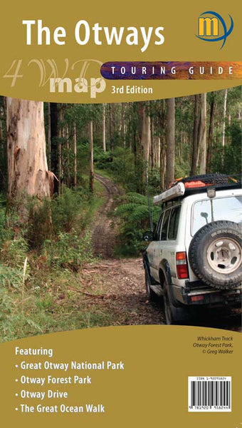
The Otways 4WD Meridian Map
$12.95
Afterpay is only available for orders between $50.00 and $1000.00 More info
Uncover the lush heart of Victoria’s southwest coast—your ultimate guide to exploring the Otway Ranges and Great Ocean Road hinterland.
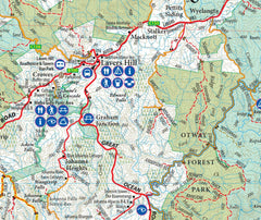
The Otways 4WD Touring Map by Meridian Maps is the definitive guide for anyone heading into the Great Otway National Park and the surrounding ranges—whether you’re tackling remote forest tracks in a 4WD, tracing waterfalls and wildlife on foot, or simply meandering through quiet country roads on a weekend getaway.
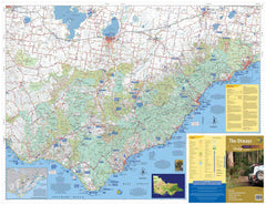
Spanning from Anglesea in the north to Princetown on the southern coast, this large-format map is beautifully detailed and thoughtfully designed for tourers, adventurers, bushwalkers, and nature-lovers alike.
🗺️ Comprehensive Regional Coverage
This map offers full coverage of the entire Otway Ranges region, including:
-
Surf coast towns such as Lorne, Apollo Bay, and Anglesea
-
Coastal points like Cape Otway, Princetown, and the 12 Apostles hinterland
-
Forest townships and access points including Beech Forest, Gellibrand, and Forrest
-
Extensive inland tracks through Great Otway National Park and associated reserves
Wherever your adventure takes you—across mountains, through fern gullies, or along windswept beaches—this map is designed to help you navigate safely and discover more.
🔍 Map Features & Highlights
-
✅ Highly detailed road and 4WD track network – Includes forestry tracks, minor backroads, major touring routes, and road surfaces.
-
✅ Walking and hiking trails – Clear markings for short walks and multi-day hikes, including terrain details for planning difficulty and elevation.
-
✅ Named waterfalls – Locate popular and hidden cascades like Triplet Falls, Hopetoun Falls, Erskine Falls, and more.
-
✅ Great Ocean Walk – Entire length mapped with clear access points, camping areas, and trail intersections.
-
✅ Otway Drive – A recommended scenic driving route showcasing the best lookouts, heritage sites, and picnic stops.
-
✅ Rail Trails – Including the Old Beechy Rail Trail and others, ideal for cyclists and walkers exploring old train routes turned into recreational paths.
-
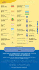
✅ Tourist symbols – Easily identify caravan parks, public toilets, picnic areas, visitor centres, accommodation zones, and fuel stations.
-
✅ Topographic relief and contour shading – Helps users visualise terrain, slopes, and forested areas for safety and navigation.
-
✅ Bush camps and informal huts – Ideal for off-grid explorers seeking a more remote experience.
All information is presented clearly and legibly, making this map suitable for first-time visitors and experienced off-road travellers alike.
🧴 Optional Lamination – Built for Field Use
Upgrade to a fully laminated version of the Otways map to make it as rugged as the trails you're exploring:
-
✅ Use whiteboard markers to plot routes, mark key stops, or track progress—then simply wipe clean.
-
✅ Apply map dots to favourite campsites, hidden waterfalls, or "must-return" spots.
-
✅ Laminated using high-quality 80-micron gloss film on both sides—making the map tear-resistant, waterproof, and perfect for repeat use in any weather.
-
✅ Great for use on the dashboard of a 4WD, spread out at the campsite, or hung on a wall for trip planning.
Note: The laminated version is produced by flattening and encapsulating a folded map. Some minor fold lines may remain visible, though they do not affect readability or function.
📐 Map Specifications
| Feature | Description |
|---|---|
| Title | Otways 4WD Touring Map |
| Publisher | Meridian Maps |
| Map Scale | 1:100,000 |
| Size | 980 mm wide × 750 mm high (unfolded) |
| Coverage Area | Anglesea to Princetown (Otway Ranges) |
| Material | Paper or laminated (user’s choice) |
| Features Highlighted | Roads, 4WD tracks, waterfalls, rail trails, walking routes, camping facilities |
🚗 Perfect For:
-
4WD explorers looking for up-to-date track details and route options
-
Caravaners and road trippers travelling the Great Ocean Road and its forested interior
-
Hikers and walkers exploring the lush tracks, waterfalls, and old rail corridors
-
Nature enthusiasts seeking campsites, wildlife areas, and secluded scenic spots
-
Eco-tourists and photographers hunting for hidden landscapes beyond the coast
-
Families and grey nomads looking for reliable and user-friendly planning tools
-
Regional tourism operators and park visitor centres using it as a reference or display map
🛒 Ordering Information
-
✅ In stock and ready to ship
-
📦 Ships rolled in a sturdy mailing tube (not folded)
-
🧴 Optional laminated version available at checkout
-
🚚 Fast, trackable shipping across Australia
-
🎁 Makes a fantastic gift for travellers, adventurers, and map lovers
🌳 Discover the Wild, Wonder-filled Otways
From towering tree ferns to whispering waterfalls, from winding coastal drives to ancient rainforest tracks, the Otway Ranges offer a rare kind of Australian wilderness. With the Meridian Otways 4WD Touring Map, you’ll have everything you need to plan, explore, and get inspired—no batteries required.


