- Australia ▾
- Topographic
▾
- Australia AUSTopo 250k (2024)
- Australia 50k Geoscience maps
- Australia 100k Geoscience maps
- Australia 250k Geoscience maps
- Australia 1.1m Geoscience maps
- New Zealand 50k maps
- New Zealand 250k maps
- New South Wales 25k maps
- New South Wales 50k maps
- New South Wales 100k maps
- Queensland 10k maps
- Queensland 25k maps
- Queensland 50k maps
- Queensland 100k maps
- Compasses
- Software
- GPS Systems
- Orienteering
- International ▾
- Wall Maps
▾
- World
- Australia & New Zealand
- Countries, Continents & Regions
- Historical
- Vintage National Geographic
- Australian Capital Territory
- New South Wales
- Northern Territory
- Queensland
- South Australia
- Tasmania
- Victoria
- Western Australia
- Celestial
- Children's
- Mining & Resources
- Wine Maps
- Healthcare
- Postcode Maps
- Electoral Maps
- Nautical ▾
- Flags
▾
- Australian Flag Sets & Banners
- Flag Bunting
- Handwavers
- Australian National Flags
- Aboriginal Flags
- Torres Strait Islander Flags
- International Flags
- Flagpoles & Accessories
- Australian Capital Territory Flags
- New South Wales Flags
- Northern Territory Flags
- Queensland Flags
- South Australia Flags
- Tasmania Flags
- Victoria Flags
- Western Australia Flags
- Gifts ▾
- Globes ▾
Dear valued customer. Please note that our checkout is not supported by old browsers. Please use a recent browser to access all checkout capabilities


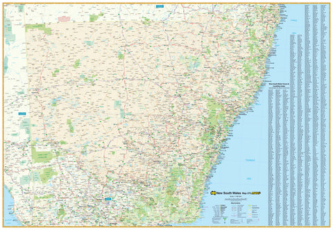
Sydney UBD 262 Map 690 x 1000mm Laminated Wall Map
$49.95
Afterpay is only available for orders between $50.00 and $1000.00 More info
An indispensable planning and reference tool for home, office, business or education — showcasing Greater Sydney with clarity, accuracy, and elegant presentation
This detailed, double-sided laminated map of Sydney is a comprehensive visual guide that offers the perfect balance between fine-grained street-level detail and a broader view of Greater Sydney’s suburban sprawl. Whether you’re a homebuyer, real estate agent, business owner, educator, city planner, or simply a passionate local, this map is built to serve both practical needs and aesthetic display.
Published in 2022, this edition provides the most up-to-date geographic representation of the Sydney metropolitan area, including roads, suburbs, postcodes, parks, and major landmarks.
🗺️ Two Maps in One – Double-Sided Design:
📍 Front Side – Central Sydney (Scale 1:25,000):
-
Covers a 10 km radius from the heart of the CBD
-
Detailed street-level mapping from:
-
Gordon in the northwest
-
North Curl Curl in the northeast
-
Monterey in the southwest
-
Malabar in the southeast
-
-
Features:
-
All major and minor roads
-
Rail lines, harbours, and ferry routes
-
Key locations including hospitals, schools, stadiums, parks, and attractions
-
-
Ideal for:
-
Urban navigation
-
Delivery zone planning
-
Residential and business location analysis
-
🌆 Reverse Side – Greater Sydney (Scale 1:110,000):
-
Covers a 75 km radius from the city centre, reaching:
-
Gosford in the north
-
Clifton in the south
-
Springwood in the Blue Mountains to the west
-
-
Displays:
-
Suburb boundaries with names and postcode overlays
-
National parks, industrial zones, and built-up areas
-
Major arterial roads and highways
-
-
Includes a complete suburb index for fast cross-referencing
📐 Map Dimensions:
-
Full Size: 690 mm wide × 1000 mm high
-
Published: 2022 (latest available edition)
-
Printed on: Premium-quality stock
-
Map Scales:
-
1:25,000 for the central side (high detail)
-
1:110,000 for the greater metro area
-
🛠️ Finishing Options:
✔️ Standard Laminate (Encapsulated Gloss Finish):
-
Protected between two sheets of 80-micron gloss laminate
-
Waterproof, tear-resistant, and long-lasting
-
Writable and erasable with whiteboard markers — great for:
-
Marking delivery zones or sales territories
-
Plotting addresses, appointments, and leads
-
Teaching or presentation use
-
-
Compatible with Mark-It-Dots (sold separately) for pinpointing locations without damage
✔️ Two Purchasing Options:
-
Flat laminated version – $99.00
-
A brand new map, professionally laminated
-
Ideal for framing or mounting
-
-
Laminated folded version – $49.95
-
A previously folded map, now laminated flat
-
More budget-friendly with some visible crease lines
-
🪵 Optional Hang Rail Kit:
For easy, ready-to-hang display, opt for natural timber hang rails, attached top and bottom with a hanging cord included:
-
Elegant lacquered wood finish blends into any home or office décor
-
Eliminates the need for framing
-
Quick, clean installation — just place a hook or nail on the wall
-
Perfect for offices, reception areas, classrooms, or home study walls
-
⏱️ Please allow 10 working days for hang-railed versions due to custom assembly
🧭 Ideal For:
-
Real estate professionals managing listings, postcodes, or client zones
-
Businesses and service providers planning deliveries, outreach, or infrastructure
-
Students, educators, and researchers studying Sydney's urban development
-
Homeowners and renters looking to understand neighbourhoods and suburbs
-
Planners and architects needing a spatial overview of urban infrastructure
-
Tourism operators or relocation consultants guiding clients through Sydney’s layout
✅ Why Choose This Map?
-
Latest edition with 2022 updates
-
One map gives both street-level and regional context
-
Highly durable and made for repeated use
-
Professionally printed and presented — a map that works just as well in a boardroom as it does in a bedroom
From house-hunting in the Inner West to planning logistics on the Northern Beaches, this Sydney Laminated Wall Map puts clarity, convenience, and regional insight right at your fingertips.
Plan smarter. Work faster. Explore Sydney with confidence — one suburb, street, and postcode at a time.