- Australia ▾
- Topographic
▾
- Australia AUSTopo 250k (2025)
- Australia 50k Geoscience maps
- Australia 100k Geoscience maps
- Australia 250k Geoscience maps
- Australia 1:1m Geoscience maps
- New Zealand 50k maps
- New Zealand 250k maps
- New South Wales 25k maps
- New South Wales 50k maps
- New South Wales 100k maps
- Queensland 10k maps
- Queensland 25k maps
- Queensland 50k maps
- Queensland 100k maps
- Compasses
- Software
- GPS Systems
- Orienteering
- International ▾
- Wall Maps
▾
- World
- Australia & New Zealand
- Countries, Continents & Regions
- Historical
- Vintage National Geographic
- Australian Capital Territory
- New South Wales
- Northern Territory
- Queensland
- South Australia
- Tasmania
- Victoria
- Western Australia
- Celestial
- Children's
- Mining & Resources
- Wine Maps
- Healthcare
- Postcode Maps
- Electoral Maps
- Nautical ▾
- Flags
▾
- Australian Flag Sets & Banners
- Flag Bunting
- Handwavers
- Australian National Flags
- Aboriginal Flags
- Torres Strait Islander Flags
- International Flags
- Flagpoles & Accessories
- Australian Capital Territory Flags
- New South Wales Flags
- Northern Territory Flags
- Queensland Flags
- South Australia Flags
- Tasmania Flags
- Victoria Flags
- Western Australia Flags
- Gifts ▾
- Globes ▾
Dear valued customer. Please note that our checkout is not supported by old browsers. Please use a recent browser to access all checkout capabilities


Sydney UBD 262 Map 1020 x 1480mm Laminated Wall Map
$365.00
or make 4 interest-free payments of
$91.25 AUD
fortnightly with
![]() More info
More info
Size: 1020 mm (W) x 1480 mm (H)
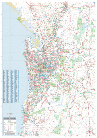
A Comprehensive View of Greater Sydney
The Sydney UBD 262 Map by UBD Gregory’s is a large-format, laminated wall map that offers exceptional detail and clarity—perfect for business use, logistics planning, education, or home offices. Covering a 75km radius from central Sydney, this map stretches from Gosford in the north to Clifton in the south, and as far west as Springwood, providing a full overview of the Greater Sydney metropolitan area.
🧭 Features at a Glance
-
Arterial roads and key transport routes clearly marked
-
Suburban areas, national parks, and industrial zones all identified
-
Every suburb name displayed, complete with postcode labels
-
Fully indexed suburb listing for quick referencing
-
Printed in full colour for easy readability and planning
-
Ideal for sales teams, operations coordinators, delivery managers, educators, and city planners
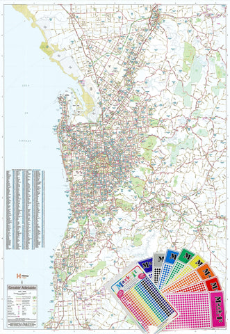
Durable, Writable, and Made for Everyday Use
Encapsulated in premium 80-micron gloss laminate, this map features a smooth, wipeable surface that allows you to:
-
Draw with whiteboard markers and wipe clean
-
Apply Mark-It Dots or stickers to pinpoint client locations, delivery zones, or sales territories
-
Resist everyday wear and tear—perfect for high-use environments
📏 Specifications
| Feature | Detail |
|---|---|
| Map Title | Sydney UBD 262 Map |
| Coverage Radius | 75km from Central Sydney |
| Includes | Suburb names, postcodes, parks, roads |
| Format | Flat, laminated wall map |
| Material | 80-micron gloss-laminated 120gsm paper |
| Size | 1020 mm (W) x 1480 mm (H) |
| Best Use | Office planning, education, logistics |
Whether you're managing operations across Sydney or simply want a comprehensive wall reference for the city and its surrounds, this high-quality map provides both form and function—combining professional presentation with practical utility.
Frequently Asked Questions
What are the dimensions of the Sydney UBD 262 Map 1020 x 1480mm Laminated Wall Map?
Mapworld wall maps range from standard 700×1000mm to large-format 1000×1430mm Supermaps. The exact dimensions for this map are shown in the product title. Where multiple sizes are available, select your preferred size when adding to cart.
Is this wall map available laminated?
Many Mapworld wall maps are available in paper, laminated, or framed finishes. Check the product options when adding to cart. Laminated maps are wipe-clean and more durable.
Is this the latest edition?
Mapworld stocks the most current editions available from all publishers. Edition year is shown in the product title where applicable. Mapworld updates its catalogue as new editions are released.
Can I write on or pin this wall map?
Laminated wall maps can be written on with whiteboard markers and wiped clean. Paper maps can be pinned on a corkboard. Choose a laminated option for a writeable surface.
Does Mapworld ship the Sydney UBD 262 Map 1020 x 1480mm Laminated Wall Map across Australia?
Yes, Mapworld ships Australia-wide. Standard shipping is a flat $7 rate, with free standard shipping on orders over $75. Express options are available at checkout. Most orders placed before 2pm AEST on weekdays are dispatched same day.
Related Items
© 2026 Mapworld. Website designed by Genie Media
X