- Australia ▾
- Topographic
▾
- Australia AUSTopo 250k (2025)
- Australia 50k Geoscience maps
- Australia 100k Geoscience maps
- Australia 250k Geoscience maps
- Australia 1:1m Geoscience maps
- New Zealand 50k maps
- New Zealand 250k maps
- New South Wales 25k maps
- New South Wales 50k maps
- New South Wales 100k maps
- Queensland 10k maps
- Queensland 25k maps
- Queensland 50k maps
- Queensland 100k maps
- Western Australia 25k maps
- Western Australia 50k maps
- Western Australia 100k maps
- Compasses
- Software
- GPS Systems
- International ▾
- Wall Maps
▾
- World
- Australia & New Zealand
- Countries, Continents & Regions
- Historical
- Vintage National Geographic
- Australian Capital Territory
- New South Wales
- Northern Territory
- Queensland
- South Australia
- Tasmania
- Victoria
- Western Australia
- Celestial
- Children's
- Mining & Resources
- Wine Maps
- Healthcare
- Postcode Maps
- Electoral Maps
- Nautical ▾
- Flags
▾
- Australian Flag Sets & Banners
- Flag Bunting
- Handwavers
- Australian National Flags
- Aboriginal Flags
- Torres Strait Islander Flags
- International Flags
- Flagpoles & Accessories
- Australian Capital Territory Flags
- New South Wales Flags
- Northern Territory Flags
- Queensland Flags
- South Australia Flags
- Tasmania Flags
- Victoria Flags
- Western Australia Flags
- Gifts ▾
- Globes ▾
Dear valued customer. Please note that our checkout is not supported by old browsers. Please use a recent browser to access all checkout capabilities


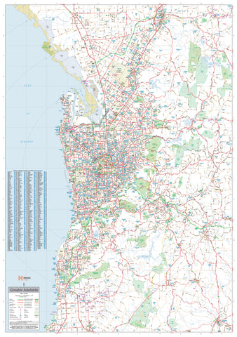
Adelaide & Region Hema 1000 x 1430mm Supermap Laminated Wall Map with Hang Rails
$299.95
or make 4 interest-free payments of
$74.99 AUD
fortnightly with
![]() More info
More info
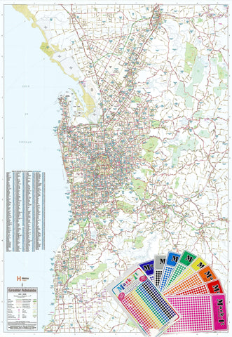
Greater Adelaide • Postcodes • Suburb Index • Planning Zones
Scale 1:56,000 | Size: 1000 × 1430 mm (W × H)
🎯 Professionally finished with gloss lamination and natural wooden hang rails – ideal for business, logistics, and display
Take control of your planning, sales, or operations with this large-format, laminated wall map of Greater Adelaide by Hema Maps. Designed for serious users who need more than just a decorative map, this Supermap edition combines accuracy, clarity, and premium materials with a ready-to-hang display finish.
Whether you're managing urban expansion, coordinating delivery zones, or simply displaying your connection to South Australia's capital, this map is an essential tool for professionals and map lovers alike.
🧭 Map Coverage
This expanded-format wall map covers the entire Greater Adelaide region, including:
-
Northern Boundary – Gawler Belt
-
Southern Boundary – Willunga
-
Eastern Boundary – Charleston
-
Western Edge – Adelaide City to the Gulf St Vincent coast
This wide-reaching coverage makes it perfect for strategic business operations, service route planning, real estate, infrastructure, or educational use.
🔍 Features & Benefits
| ✅ Feature | 💬 Description |
|---|---|
| 🛣️ Comprehensive Road Network | Includes all primary, secondary, and local roads clearly marked |
| 🚧 Transport Infrastructure | Displays metropolitan roads, state and national route numbers, and both existing and future freeway corridors |
| 📮 Postcode Boundaries | All postcode zones clearly overlaid across the entire map |
| 🏘️ Suburb Index | Complete suburb index for quick and easy reference |
| 🗺️ Large Scale | Large scale of 1:56,000 ensures exceptional detail, especially in dense metropolitan areas |
| 🧱 Planning Utility | Ideal for logistics, infrastructure projects, sales teams, and business development |
| ✍️ Writable Surface | Gloss lamination allows you to write with whiteboard markers and use Mark-It-Dots without damaging the map |
| 🪵 Timber Hang Rails Included | Natural wood hang rails fitted top and bottom, with hanging cord pre-attached — just hook and display! |
🖨️ Premium Materials & Craftsmanship
This edition is expertly printed and mounted to meet the needs of professionals, with materials chosen for durability and visual clarity:
-
🧾 Base: 120 gsm FSC matte-coated paper
-
🎨 Ink: Archival-grade pigment ink – fade-resistant and vibrant
-
💧 Lamination: Two-sided encapsulation in 80-micron gloss laminate – tear-resistant and waterproof
-
🪵 Hanging System: Natural lacquered timber rails with secure hanging cord
-
🇦🇺 Printed & assembled in Australia
📐 Product Specifications
| Specification | Details |
|---|---|
| Title | Adelaide & Region Supermap |
| Publisher | Hema Maps |
| Scale | 1:56,000 |
| Size | 1000 mm (W) × 1430 mm (H) |
| Material | Laminated (80-micron gloss) |
| Ink | Pigment-based, fade-resistant |
| Finish | Writable, laminated surface |
| Mounting | Timber hang rails (top & bottom) |
| Hanging Cord | Included – pre-attached to top rail |
| Framing Required | No – ready to hang |
| Suitable For | Offices, classrooms, logistics hubs, councils |
| Country of Manufacture | Australia |
🛠️ Applications
-
🏢 Business & Operations Planning – Ideal for routing, sales territories, or planning zones
-
🚚 Logistics & Delivery Teams – Clearly identify suburbs and postcode boundaries for dispatch
-
🏫 Educational Use – Perfect for geography, urban studies, and local history lessons
-
🏛️ Council or Government Display – Functional and professional for town halls, chambers, and departments
-
🏠 Stylish Home Display – Add a thoughtful and locally relevant focal point to your workspace or study
🚚 Delivery & Framing Notes
📦 Please allow up to 10 business days for delivery
Our experienced framer will professionally attach the timber hang rails prior to dispatch, ensuring your map arrives ready to hang with zero fuss.
🛒 Order Now – A Professional-Grade Adelaide Wall Map
If you're looking for clarity, scale, and a superior finish, this Hema Supermap is the definitive choice for Adelaide-focused planning. Functional, visually compelling, and built to last — it’s more than a map, it’s a smart investment.
Frequently Asked Questions
What are the dimensions of the Adelaide & Region Hema 1000 x 1430mm Supermap Laminated Wall Map with ?
Mapworld wall maps range from standard 700×1000mm to large-format 1000×1430mm Supermaps. The exact dimensions for this map are shown in the product title. Where multiple sizes are available, select your preferred size when adding to cart.
Is this wall map available laminated?
Many Mapworld wall maps are available in paper, laminated, or framed finishes. Check the product options when adding to cart. Laminated maps are wipe-clean and more durable.
Is this the latest edition?
Mapworld stocks the most current editions available from all publishers. Edition year is shown in the product title where applicable. Mapworld updates its catalogue as new editions are released.
Can I write on or pin this wall map?
Laminated wall maps can be written on with whiteboard markers and wiped clean. Paper maps can be pinned on a corkboard. Choose a laminated option for a writeable surface.
Does Mapworld ship the Adelaide & Region Hema 1000 x 1430mm Supermap Laminated Wall Map with across Australia?
Yes, Mapworld ships Australia-wide. Standard shipping is a flat $7 rate, with free standard shipping on orders over $75. Express options are available at checkout. Most orders placed before 2pm AEST on weekdays are dispatched same day.
Related Items
© 2026 Mapworld. Website designed by Genie Media
X